Tuesday, December 30, 2008

The Best of 2008

I know that year-in-review articles are lazy and I've debated whether or not I should post one here. But as you can see, I've decided to do it. I know that I gained a lot of new readers with November's post on how soil types determined voting patterns in the Deep South. That may well have been the most interesting thing I will ever write and my crowning achievement as a blogger.

Still, even if the other posts on this blog can't quite live up to that standard, I still think they're somewhat interesting, and worth a visit.

From January:
Shout-outs to my mentors in urban wilderness appreciation: Mark Dion and William Cronon. I was also on a bit of a militaristic kick a year ago, with posts on Korea's DMZ wilderness area and the military heritage of European-style boulevards.

From February:
The next manifest destiny for the American west: parched and scorched suburbs. Speaking of suburbs, land trusts in wealthy suburban communities like Cape Elizabeth, a blue-blooded coastal suburb of Portland, are more interested in preserving real estate values than they are in providing real environmental benefits.
A new wind turbine rivals the downtown garbage incinerator's smokestack in a small Maine city's skyline.

From March:
More on the Manifest Destiny and "American Progress," the way it looked 130 years ago.
Action and adventure: I scale Portland's Bayside Glacier! A few days later I witness a bloody mid-air battle a few blocks from my house (and get some gruesome photos to prove it!).
And during spring break in Houston, we visit the Ocean Star Offshore Energy Museum: marvel at the Gulf Coast's incredible money machines.

From April
:
With energy and food prices rising in tandem
, ethanol would appeal to Marie Antoinette, I think: Energy crisis? Let them burn cake.
I also dig through Henry Wadsworth Longfellow's old basement and find some victorian-era junk before they bury it all under a new hotel in downtown Portland.

From May:
The growth of city street networks follows the same mathematical pattern as the growth of leaf capillaries or cells in living organs: cities are organic. May is plastic blogging month at the Vigorous North: I write about Portland's plastic spring foliage, and the Pacific Ocean's floating plastic island. Recycling plastic is a no-no in Berkeley, but it might be OK in Maine.


From June:
A proposal for new storm drain stencils. The geography of "cyberspace" is fading away, but the human ideome project is just beginning.
The foreclosure crisis transforms swimming pools into vernal pools throughout the Sun Belt.
Maine's working waterfronts used to rely on local natural resources, like our fisheries and timber. Now, military contracts keep our few remaining shipyards in business.

From July:
America means choice: comeuppance for Ford and General Motors.
New parks are exhuming pieces of London's ancient rivers.

From August:
Monuments in city parks? Nature abhors a statue. It's summer in Maine, blogging takes a break.

From September:
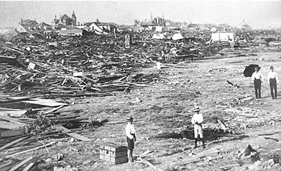
Ike bears down on Texas, and I write about how Galveston lifted itself up (literally) after the devastating 1900 hurricane.
Portlandhenge, LAhenge, DChenge, and the autumnal equinox.
Sometimes, inner-city "open space" is bad for the environment.

From October:
A hiking guide to Portland's Stroudwater Trail.
An urban wildlife guide to the Virginia Opossum, the spirit animal of President Taft.
Hundreds pack a Lewiston chapel to hear their pope Michael Pollan speak.

From November:
Wildlife corridors in Pittsburgh, and other inner-city wilderness areas in the news.
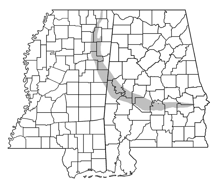
The big story, thanks to attention from Kottke.org and many others, was about how Obama owed his success in the deep south to the rich, loamy soils laid down 85 million years ago, in the late Cretaceous period. Down in Dixie, the blue counties have black people and black soil; red counties have red clay.

From December:
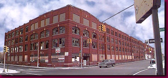
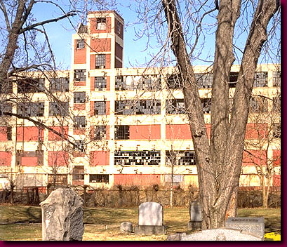
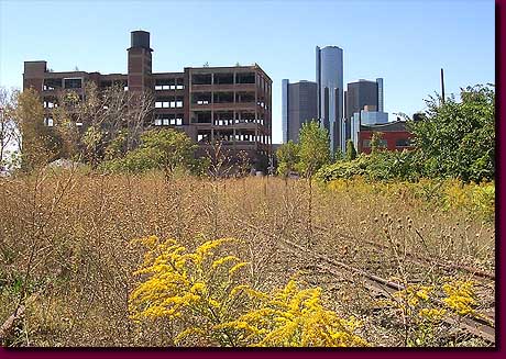
A $17 billion tour of the fabulous ruins of Detroit.
Urban snapping turtles as "the fatty palimpsest on which the toxic legacies of our lakes and rivers are chronicled."
Portlandhenge returns: the winter solstice on Winter Street.

Happy new year!

Monday, December 22, 2008

Eye on the Pipeline

My friends Nate and Iona just moved to town and got an apartment with a splendid view of the South Portland oil terminal. They just put up a new website, and Nate has already written a post on the supertankers that dock here, ejaculate their oil, and head back to the oil fields.

According to Nate, there's a very loose network of global ship enthusiasts that tracks the comings and goings of these ships in various harbors around the globe, but coverage is spotty. Once upon a time, local newspapers in coastal cities would report all of the ships that came into port on a given day. Apparently harbor traffic is less newsworthy today, but Google searches can turn up some interesting info. For instance, a quick search for "MT Waltz," the ship that Nate photographed the other day, uncovers this undated press release. Apparently the Waltz is a brand-new ship, which was scheduled to be delivered to its owners, Hartmann Shipping, on April 30 of this year.

Said press release also declares that "the vessels MT 'Tango' and MT 'Waltz' are so-called 'Green Ship Suezmax Tankers', which are built in compliance with latest antipollution-standards." A green oil tanker - the whales and dolphins must be so happy!

But if more curious harbor-watchers like Nate were able to accurately track the transoceanic commerce of these ships, we might have a better idea of where our oil is really coming from. It could be a black-gold analogue to the BBC's The Box project. Is our oil British, from the fields of the North Sea? Or Arabian? Russian? Venezuelan? For now, that's the proprietary knowledge of shipping and oil corporations - but it's knowledge that's free for the taking, for anyone with harbor views.

Friday, December 19, 2008

Portlandhenge II


The (almost) winter solstice sunrise, looking along the length of Winter Street.

For more, see The Autumnal Equinox: West Street, or Portlandhenge Returns, or this post on Cityhenges in general.

As a side note, how would you answer the following mathematical problem?

Let E(x) be the function of Embarrassment, and let A(y) be the function of Awesomeness. Fill in the blank:

A(Portlandhenge) _____ E(Publishing a photo of your grimy windows)  +  E(Publishing a photo that you took five minutes after waking up in a 45-degree apartment, and is so poorly composed that an amorous tryst between a digital camera and a snapping turtle would have produced a better result)


As you can see, I chose ">".

Thursday, December 18, 2008

The Garden

Tonight at Portland's SPACE Gallery they'll be screening "The Garden," a documentary about Los Angeles's South Central Farm.

The Farm enjoyed a vibrant 12-year history as a diverse ecosystem of central American crop plants raised on small plots by about 350 local families. It also served, temporarily, as one of the largest green spaces for South Central Los Angeles, an area with a high proportion of minorities and elevated levels of air pollution (in the 1980s, the City of Los Angeles temporarily owned the site with the intention to build a new garbage incinerator, but environmental justice protests sank the proposal).

Ultimately, though, southern California's red-hot real estate market scorched the farm. Bulldozers ripped through the site in 2006, but not before some high-profile protest songs by Joan Baez, and a two-week tree sit by a group that included Daryl Hannah (yeah, that Daryl Hannah: tabloid story here, Daryl's first-person account here).

The forty-acre farm site is now a barren, empty lot, surrounded by razor wire. Just as soon as the real estate lawyers beat the farmers' pro bono legal team into submission, the site will sprout a new Forever 21 distribution center and warehouse.

For more info:
The Garden movie website
South Central Farmers: official web site

Tuesday, December 16, 2008

Wilderness game theory

Above: female lechwe in Botswana. Courtesy of Wikimedia Commons.

There are three things that tickle me about The Economist: fun, safety, and their writers' knack for tying a broad range of topics into the free-market economic theories of Adam Smith.

To wit: this week's issue includes a summary of new research that demonstrates that a rare species of African antelope, the Nile lechwe, is somehow capable of making strategic decisions about whether to give birth to a male or female offspring, depending on its age, in order to maximize the probability of passing on its genes to future generations.

For some as yet unknown reason (possibly because sons are generally heavier), lechwe are three times more likely to die in childbirth while delivering a son than they are while delivering a daughter. So giving birth to a son is a risky proposition for a lechwe. It's also more of a genetic gamble: a male lechwe has some chance of becoming dominant and breeding a lot, which could be a genetic jackpot, but if a male fails to become dominant, it becomes a genetic dead-end. Daughters, on the other hand, are the safer bet, since nearly all females breed and will pass on some of your genes to another generation.

In theory, if a mother could somehow choose between sons and daughters, a lechwe should choose to give birth to more daughters while she's young, then take a chance on a son or two once they're old and expect to die soon anyhow. If possible, the mother should also put in more resources into making sure that her offspring are larger as she gets older, so that if she does give birth to a male, it has a better chance of becoming dominant.

It's more or less the same strategy that explains the old Publishers' Clearinghouse Sweepstakes contests and their demographics. The Sweepstakes take up a lot of time and postage, and the odds of payout are so low that most young or working people couldn't be bothered by it [if you doubt the demographics, how do you explain Ed McMahon's spokesmanship and the fact that the ads always ran among pitches for Metamucil and adult diapers?]. But if you're old, retired, and have nothing better to do with your time, why not buy crappy paperback novels you don't want and spend hours at the post office? After all, you could win ten million dollars!

Of course, a variable reproductive strategy would assume that lechwe are capable of dynamic optimization, a complicated subdiscipline of economics that utilizes multivariable calculus. But as it turns out, lechwe somehow are capable of changing and optimizing their reproductive strategy as they age.

Researchers at the San Diego Zoo's 90-acre Wild Animal Park witnessed the birth of over 176 lechwe calves over a 38-year period. They found that yearling lechwes had sons 57% of the time, but by the time those mothers became seven years old (roughly middle age for a lechwe, whose average lifespan is 12 years) the odds of having a son rises to 67%.

Not only that, but older mothers are more likely to give birth to larger offspring as well.

Lechwe probably aren't capable of making a conscious choice between male and female offspring, the way humans might choose between small-cap and fixed-income IRAs. But the dependence of their reproductive strategy on age does indicate that the lechwes' reproductive strategy is the product of evolution: females who are more likely to give birth to males later in life are more likely to pass their genes on to future generations; therefore, after thousands of generations of lechwes, most females somehow possess this unusual reproductive characteristic.

With some imagination, an alternative solution to our credit crisis presents itself: let humans breed for a few dozen more generations, and the surviving offspring of our most fertile and successful money managers will be able to solve our financial problems with ease.

Tuesday, December 09, 2008

Chelydra serpentina


Photo: Wikimedia Commons.

The Common Snapping Turtle, Chelydra serpentina, is a common dweller of inner-city wildernesses, especially in rivers and shallow lakes.

Snapping turtles typically live about 30 years in the wild, which is an unusually long life span among species of urban wildlife. This, combined with their opportunistic, omnivorous diet (snappers are important aquatic scavengers) means that urban turtles' fatty tissues end up absorbing a lot of toxic substances from their environment.

This Canadian research paper analyzed turtle eggs at various sites around the Great Lakes, including in so-called "Areas of Concern" like the Detroit River and the Hamilton Harbor complex southwest of Toronto. From the abstract:
PCBs, organochlorine pesticides and dioxins/furans in snapping turtle eggs and plasma (Chelydra serpentina) were evaluated at three Areas of Concern on Lake Erie and its connecting channels (St. Clair River, Detroit River, and Wheatley Harbour), as well as two inland reference sites (Algonquin Provincial Park and Tiny Marsh) in 2001–2002... Dioxins appeared highest from the Detroit River. The PCB congener pattern in eggs suggested that turtles from the Detroit River and Wheatley Harbour [sites] were exposed to Aroclor 1260... Although estimated PCB body burdens in muscle tissue of females were well below consumption guidelines, estimated residues in liver and adipose were above guidelines for most sites.
Even more interesting, a short blurb on snapping turtles from the book Concrete Jungle, edited by Mark Dion and Alexis Rockman (Juno Books, 1996) asserts that
In some areas, when the turtle dies it must be treated with toxic waste protocols.
The long-lived snapping turtle: the fatty palimpsest on which the toxic legacies of our lakes and rivers are chronicled.

Thursday, December 04, 2008

The Fabulous Ruins of Detroit

With overpaid executives begging Congress to keep a shrinking, 1920s-era industry limping along for another few months (just in case Hummers come back in style), it seems like a good time to showcase one of my favorite websites: The Fabulous Ruins of Detroit.

This Studebaker plant built autos between 1910 and 1928, and burned to the ground in 2005. The Studebaker corporation produced its first electric autos in 1902, and its first gasoline autos in 1904. Its car manufacturing business was defunct by 1964:


Packard Motors produced its first automobiles in 1899, and closed its last plants in 1956:


East of downtown, the former industrial Rivertown neighborhood is one of many accidental restoration sites where wild prairie ecosystems are re-infiltrating the city center. Looming in the background is "The Renaissance Center," the ironically-named GM headquarters complex, aloof from its surroundings, destined to become Detroit's next fabulous ruin.

Tuesday, December 02, 2008

Five Gigawatts in the Gulf of Maine

Floating wind turbine A concept drawing of a floating wind turbine, using technology from floating oil-drilling rigs. From
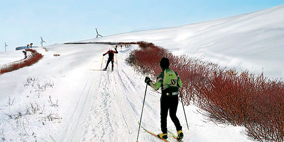
 StatoilHydro.

Midcoast Maine is becoming more and more like a Houston country club: every summer, more retired Texan oil millionaires arrive to fly the Lone Star flag from their waterfront summer homes. But one of those millionaires, Matthew Simmons, of Simmons & Company International, has taken his retirement from the fossil-fuel industry to an unusual extreme.

In the past year, Simmons has become the "prophet of peak oil," citing his extensive geological knowledge to argue that the world's supply of oil can't keep up with demand, and has predicted middle-term oil prices to rise as high as $300 a barrel (the recession, of course, has evened the balance between consumption and production for the time being). Here's a clip of him on CNBC last year.

Simmons is very concerned that the existing economy can't sustain itself with dwindling supplies of oil. So he started the Ocean Energy Institute, a nonprofit based in Rockland that's dedicated to finding alternative energy sources derived from the oceans. Maine could become to renewable energy what his old hometown of Houston was to oil.

The Institute has quietly floated a plan to build a 5 gigawatt complex of floating wind turbines far offshore in the Gulf of Maine. As proposed, the project could produce more electricity in steady winds than all of the state's existing power plants combined. Even more power is possible, but the 5 gigawatt scale was chosen because that's how much electricity it would take to replace oil as a source of winter heat in Maine's buildings.

At this point, it seems more like a thought experiment than a serious proposal: the $25 billion price tag is more than double the amount of T. Boone Pickens's monumental wind farm in the Texas panhandle. But unlike Pickens's project on the prairie, this one would be a lot closer to the cities where electricity is consumed, which means that its transmission costs could be significantly lower.

So if the economy does recover and oil shoots back up to $300 a barrel - in three to five years, say - I could see this moving forward. With it would come a huge mobilization of workers in Maine's shipyards, the likes of which haven't been seen since World War Two. Imagine the work required to install two thousand wind turbines onto floating platforms, ship them out to sea, connect them to the grid, and keep them in good working condition.

In the past half century, Maine's industries have mostly turned their backs to the sea, and our state's shipbuilding tradition has mostly relied on largesse from the military. We've also gone from heating our homes with wood we grew in our own forests, to heating them with oil from God knows where. Maybe 21st-century wind power technology will restore Maine's traditions of self-reliance, and hard work on the high seas.

Wednesday, November 26, 2008

Inner-city wilderness areas in the news

Some recommended reading:

Robert Sullivan (the same guy who wrote Rats) has an article in New York Magazine about Fresh Kills Landfill, where piles of garbage "about the height of Mexico’s Great Pyramid of Cholula" are currently being repurposed to become one of New York City's largest parks. Here's a post I'd written about Fresh Kills Park last summer.

In an age when our remaining inner-city wildnernesses are usually abandoned industrial or military sites, the new park's designers are hoping to set a new standard in park design: "They would not build a new park on top of an old dump. Instead, they would make the old dump a part of the new park, by acknowledging it, reclaiming it, recycling it on behalf of a modern metropolis."


The future of Fresh Kills: cross-country skiing on half a century's accumulation of garbage. Rendering courtesy of Field Operations.

Sullivan's article is also rich with garbage trivia: the Sanitation Dept. processes 312 gallons of liquid dump excretions from Fresh Kills every minute. "Henry David Thoreau, living in Staten Island while trying to get freelance writing work in Manhattan, used to walk onto the marsh island in Fresh Kills to dig arrowheads, 'the surest crop.'” And the urban archaeological artifacts buried there include "a million dollars’ worth of cocaine and heroin accidentally lost in a garbage scow (1948); eight capsules of radium accidentally taken from a doctor’s office (1949); a leg, possibly from a gangland-style hit (1974)."

Read the whole story here, or find out more about Fresh Kills Park from the official City website.

Elsewhere, the Times Escapes section ran a story last week on inner-city hiking trails with city skyline views. The article included trail recommendations in DC, Pittsburgh, Philly, NYC, Hartford, Boston, and Portland. All good places to walk off your Thanksgiving meals.

Friday, November 21, 2008

Red States and Red Clay

Thanks for all of the links and compliments on the Black Belt post. It's been really gratifying to watch all of the pings come in from blogs all over the world, and with such kind compliments, too. I certainly thought it was neat, and I'm glad so many others agreed.

To those of you who are new visitors, my goal with this blog is to discover and write about the complex relationships between ecology and society. The maps of black belt soils and voting patterns were a particularly elegant and striking example of the sort of geographic connections I'm fascinated by. If you liked that post, you should also check out Portlandhenge, the Downtown Portland Glacier, From Swimming Pools to Vernal Pools, and The ExxonMobil Arena/Disaster Shelter.

Red soil in red counties: Commenter Michael, in the Black Belt post below, pointed out that "as you travel into the politically red areas, it's also literally red, as river sediments give way to red clay. My guess is that the red dirt isn't nearly as good for farming."

I did some background research on this and found that it's true. Actually, the black belt itself features a good deal of red clay, but it's underneath a surface layer of rich, black and loamy topsoil. The photo at right shows a sample of "Bama soil," the official state soil of Alabama. Note the thinner layer of black soil on top of a thicker layer of red, iron-rich clay.

Clay soils are typically the remnants of ancient marine sedimentary deposits, so naturally, there's a lot of clay in the Black Belt and just to its south. But this essay from the Alabama Dept. of Conservation explains that black belt soils have a thicker layer of black, more fertile topsoil because of its chalk content. The chalk fostered prairie grasses, which, over millions of years, accumulated into a dark, nutrient-rich topsoil. South of the Black Belt, where the Cretaceous seas were deeper, there's less chalk. Which means less fertile soil. Which means they supported fewer antebellum slave plantations. Which means more Republicans live there today.

But their gardens are probably lousy.

Monday, November 17, 2008

The Black Belt: How Soil Types Determined the 2008 Election in the Deep South

Edit: credit for the original insight on the cotton-electoral connection seems to belong to Allen Gathman, a biology professor at SE Missouri State University. The Pin-the-Tail blog referenced previously seems to have picked it up later and failed to attribute the source; the post below has been corrected accordingly.

This is not a political blog. However, this is a story I couldn't pass up: the story of how voting patterns in the 2008 election were essentially determined 85 million years ago, in the Cretaceous Period. It's also a story about how soil science relates to political science, by way of historical chance.

It's also a story best told with maps, beginning with this one:


This is the map showing county-level election results in the southeastern USA, courtesy of the New York Times website. Most of these are "red" states, but the county-level detail shows an interesting phenomenon: a crescent of blue that runs in an arc from the Mississippi River floodplain to central North Carolina. This had struck me as curious when I saw it after the election, but I regret that I didn't investigate it further until the story was explained over the weekend on the Strange Maps blog.

Allen Gathman, a biology professor in Missouri, had also seen the pattern and recognized it as a function of land use in the deep South. He posted the electoral map above alongside a map of cotton production in 1860: sure enough, the "blue" counties correlated with cotton production in the slavery era. Here's a mash-up of the two maps from Strange Maps contributor Mark Root-Willey:


Each dot in the overlay map represents 2,000 bales of cotton production in 1860. Recall from your American history class that cotton production, a high-value but labor-intensive industry, was one of the prime economic reasons why Southern states chose to maintain the institution of slavery instead of maintaining the Union.

Fascinating stuff, but these maps reminded me that I had seen a similar pattern before, in satellite maps like this one:


View Larger Map

There's that crescent again. A closer look reveals that the lighter-colored band in the satellite image consists mostly of agricultural fields. Here's a detail of Noxubee County, one of the blue counties in eastern Mississippi that's located in the middle of the crescent:


View Larger Map

It turns out that this crescent actually has a name: the "Black Belt," a name that refers both to the area's racial demographics and to the rich, loamy soils that were ideal for cotton crops.

Allen Tullos of Emory University has an excellent essay on the Black Belt that's available online from the Southern Spaces journal. His article observes that
Half of Alabama's enslaved population was concentrated within ten Black Belt counties where the exploitation of their labor made this one of the richest regions in the antebellum United States.
Tullos's essay also includes a quote from Booker T. Washington, who gave this assessment of the Black Belt in 1901:
"I have often been asked to define the term 'Black Belt.' So far as I can learn, the term was first used to designate a part of the country which was distinguished by the colour of the soil. The part of the country possessing this thick, dark, and naturaly rich soil was, of course, the part of the South where the slaves were most profitable, and consequently they were taken there in the largest numbers. Later, and especially since the war, the term seems to be used wholly in a political sense - that is, to designate the counties where the black people outnumber the white.
A hundred years later, the "black belt" still contains a high concentration of African Americans, who, as a demographic group, voted overwhelmingly in favor of Barack Obama.

To review so far: the blue counties can be explained by the black population, whose ancestors were brought there because of white supremacy, and black soil.

But how did the soil get there, and why is it in this unusual crescent-shaped band? In an essay on the area's ecology, Joe MacGown, Richard Brown, and JoVonn Hill of the Mississippi Entomological Museum write that "the entire region is underlain by Selma Chalk formed from Upper Cretaceous marine deposits. Depending on the exact consistency of the parent material, the chalk weathers into a variety of soil types which supports a mosaic of habitats ranging from prairie to forest." Here's their map of this geological formation - look familiar?


One last map to bring it full circle, from blue counties, to ancient blue seas. Below are two maps of North America in the late Cretaceous Period, made by Professor of Geology Ron Blakey at the University of Northern Arizona. The map on the left shows the South during the early Cretaceous, about 115 million years ago, and the map on the right shows the South during the Late Cretaceous, about 85 million years ago. These shallow, tropical seas, teeming with marine life, laid the deposits that would eventually become the rich "black belt" soils. Note how the crescent of cotton farms in 1860, and of Democratic-voting counties in 2008, also follows the crescent of these ancient shorelines:


For further reading:
Allen Tullos, "The Black Belt." From Southern Spaces, April 2004.

Joe MacGown, Richard Brown, and JoVonn Hill, "The Black Belt in Mississippi." From the Mississippi Entomological Museum.

Ron Blakey, "Paleogeography and Geologic Evolution of North America: Images that track the ancient landscapes of North America"

Friday, November 14, 2008

Climate Change: a Monroe Doctrine for the Arctic

From Der Spiegel:
Ironically, while the world worries about climate change, global warming is triggering great hopes in Greenland. If the Arctic waters were truly ice-free in the summer in five to 10 years, which would be significantly sooner than previously feared, this could be good for Greenland -- at least economically.

The port of Qaqortoq in southern Greenland. From Der Spiegel.
Almost 200 years after the Monroe Doctrine, climate change is making the relationship between the Kingdom of Denmark and its arctic colony about as substantial as the melting pack ice. Geographically, Greenland (technically a "semi-autonomous republic") is the largest remaining European colony in North America. Its predominantly Inuit population drives a hardscrabble economy: Greenland exports lots of fish, and it imports lots of alcohol.

But with melting ice and increasing global demand for natural resources, Greenland looks set to storm into the global economy. The island stands to become a sort of Arctic Dubai by exploiting tremendous offshore oil reserves, which, in turn, will help accelerate the disappearance of the ice that's holding it back.

Thursday, November 06, 2008

The Pittsburgh Menagerie


A flock of wild turkeys (crossing the street below the bridge) in a ravine of Pittsburgh's Schenley Park. Photo courtesy of Timothy Wisniewski.
From the Pittsburgh Tribune-Review, zoologist Mark Browning lists some of the wildlife sightings he's had in the Steel City: bobcats, coyote, ravens, beavers, red foxes, herds of deer and flocks of wild turkey, bald eagles, and river otters.

Pittsburgh is characterized by steep hillsides (hence the city's famous inclines) and undeveloped ravines, which act as wooded wildlife corridors for critters moving into the city from the rural outskirts. Since passage of the Clean Water Act, animals like beavers, otters, and bald eagles have moved in to reinhabit the banks of the Allegheny and Monongahela Rivers. As in any city, humans' backyards, garbage, and feeders, plus an absence of predators, attract other mammals, like rats, coyote, and deer.

Wednesday, October 29, 2008

The Zoo of Processed Meats

And speaking of "real food" and the imperative of being more aware of where your meals come from, Banksy has opened a new pet store where a lot of industrialized critters have been rescued from the freezer case to wait for a good home. Sort of like a humane society for processed meats and lab bunnies. It's only open until Halloween in NYC's East Village - go if you can!


Find more domesticated consumer products - not just processed foods - in terrariums at the Village Petstore and Charcoal Grill.

Tuesday, October 28, 2008

The Church of Michael Pollan

Last night I joined Portland Psst! and the Jordans Meats Mycologist on a trip to Bates College in Lewiston for a free lecture by Michael Pollan, the journalist who's become a guru for the organic/local foods movement by virtue of his three most recent books, In Defense of Food, The Omnivore's Dilemma, and The Botany of Desire.

The Bates College chapel, allegedly the largest venue on campus, was ridiculously packed, with at least seven hundred people of all ages in attendance. The fire marshall made about a hundred people in the aisles leave before the lecture could begin.

Pollan was an engaging speaker, and had a quiver of entertaining anecdotes about the food and nutrition industries. His main arguments were aimed to dispel the notion that we can understand human dietary needs or dietary evils as discrete sets of chemical nutrients. Real foods, he pointed out, are complex, living systems, much like the human digestive system. Principles of "nutrition" are little more than articles of faith.

In fact, Pollan's opening remarks laid out a number of similarities between the nutrition industry and organized religion. I found the metaphor a bit ironic, given the fact that he was standing in the pulpit of a chapel and speaking to hundreds of eager disciples. I completely agree that we spend too much time obsessing over what we eat (mostly, whether it has trans fats, or omega threes, or corn syrup, or animal products, or whatever). But at the same time, as the huge crowd attests, the American obsession with food has been very, very good for Pollan and his book sales.

What Pollan is really asking us for is for a different kind of obsession over our food. Instead of poring over abstract "Nutrition Facts," we should think more about where our food comes from and the natural and human resources that brought it to us. If we knew more about the differences between a home-cooked meal and a processed TV dinner sourced from feedlots and agribusiness factories, or the differences between an organic apple shipped from New Zealand and an unlabeled apple from the orchard five miles away, then our economy, our environment, and our bodies would probably all be a lot healthier.

As someone who obsesses over where my sewage goes, I'm only too happy to explore where my food came from. And as an aspiring interpreter of the urban environment, I'll be curious to see how Pollan convinces the rest of America to become agro-naturalists.

Pollan's dietary advice boils down this seven-word incantation: "Eat food. Not too much. Mostly plants." To which I would only add, "And get over yourself already."

Thursday, October 23, 2008

San Francisco Bay, in 1915 and 2008


Source of historic map: San Francisco History Index, by Z Publishing.

Some landmarks of note: Treasure Island, which does not exist in the 1915 map, is an artificial island originally used as an airport and built from landfill that was dredged from the bottom of the Bay during the Great Depression.

The Port of Oakland was also constructed from landfill on the northern side of San Antonio Creek. Some landfilling work is already evident in the 1915 map. The airstrip on the south side of the Creek in the 2008 view is the Alameda Naval Air Station.

To view the entire map overlay in Google Earth or Google Maps, I've posted this overlay as a KML file on the Google Earth Community.

Monday, October 20, 2008

Opossums, William Howard Taft, and an important book for your survivalist cache

Continuing an occasional series of posts on urban wildlife, here is everything you need to know about North America's native marsupial, the Virginia Opossum (Didelphis virginiana).


Not playing possum: a roadside opossum carcass in suburban Yarmouth, Maine.


One benefit of riding my bike to work in the suburbs is my frequent sightings of urban and suburban wildlife species. Most of them are roadkill.

Because of roads, fragmented habitat, and other characteristics of urban landscapes, the wildlife habitats in which humans are the dominant species tend to favor critters like the opossum, which, like the Norway rat, has a short life span, a flexible diet, and large litters of offspring. Thanks to suburbanization, the Virginia opossum's range is actually increasing, north into Canada and to the west coast.

It's unclear why, but the opossum is frequently associated with hillbilly culture. Abroad, other opossum species are a popular game animal, and as late as the 1960s, opossums were a common enough source of food to warrant this recipe in the Joy of Cooking:
"If possible, trap 'possum and feed it on milk and cereals for 10 days before killing. Clean, but do not skin. Treat as for pig by immersing the unskinned animal in water just below the boiling point. Test frequently by plucking at the hair. When it slips out readily, remove the possum from the water and scrape. While scraping repeadedly, pour cool water over the surface of the animal. Remove small red glands in small of back and under each foreleg between shoulder and rib. Parboil... 1 hour. Roast as for pork, page 421."*
At the turn of the last century, there was an effort to market "Billy Possum," which was associated with William Howard Taft's presidency as the "Teddy Bear" was with Roosevelt's.

Unfortunately, none of the "Billy Possum" references I found were able to provide context for the phenomenon. I'm sure there's scholarly research, somewhere, on whether the "Billy Possum" was a legitimate marketing effort from the stuffed animal industry or a Democratic Party insult against William Howard Taft. Either way, Billy Possum didn't catch on.**

Here's a fact that doesn't really fit anywhere in the narrative, so I'll make a cheap pun and stick it here (and here): the "Didelphis" in the opossum's scientific name refers to the animals' bifurcated sex organs.

There's an Oppossum Society of the U.S. which laments the plight of opossums in urban habitats: "As development of once rural land increases, the opossum continues to be pushed out of its natural habitat and forced into closer proximity to people, often with injurious consequences to the opossum."

The OSUS has an unusually cute picture of an opossum on their home page, but come on: these are animals that survive 2 years, at the most, in the wild. Providing "for the care and treatment of injured and orphaned wild opossums for release back into the environment," as the Opossum Society does, kind of seems like coddling an adult human in a nursing home for twenty years, then dumping him naked in the Alaskan wilderness for his retirement.

*By the way, according to the source of this passage, the 1962 edition of Joy of Cooking also includes this illustration of how to skin a gray squirrel:Urban survivalists, take note: a mid-century edition of The Joy of Cooking is an essential addition to your apocalyptic supply cache.

**Taft didn't catch on, either: he received the worst reelection drubbing in American history when he finished a distant third behind Woodrow Wilson and Teddy Roosevelt in 1912. His post-presidency honors are pretty scant, but the town of Moron, California did decide to honor Taft by changing its name after a big fire in the 1920s (according to Wikipedia).

Thursday, October 16, 2008

Edward Burtynsky's "Manufactured Landscapes"

For the next month, Bowdoin College's "Center for the Common Good" is hosting a number of events centered around the "Manufactured Landscapes" photography of Edward Burtynsky.


Edward Burtynsky: Oil Refineries No. 18,
Saint John, New Brunswick 1999


Burtynsky is an Ansel Adams for 21st-century environmentalism. Like Adams, he produces stunning, large-format photographs that are beautiful and can induce a sense of vertigo from their epic scale. While Adams was closely associated with 20th-century environmental groups like the Wilderness Society and Sierra Club, and was a strong advocate for preserving an idea of "pristine" nature, Burtynsky makes the human use of nature - in places like mines, Chinese factories, and landfills - his primary subject. Burtynsky is also aligned with the vanguard of 21st-century environmentalism, WorldChanging.com (check out this video he made for them).


Edward Burtynsky: Bao Steel #2,
Shanghai, 2005


Unfortunately, I'm afraid the internet can't do fair justice to these photographs. Luckily for those of us who live in Maine, an exhibition of Burtynsky's photographs will run at Bowdoin College in Brunswick from October 23rd to Christmas, in conjunction with a number of lectures and screenings of Jennifer Baichwal’s documentary of Burtynsky. Here's the schedule of events.


Tuesday, October 07, 2008

Urban Hiking: Portland's Stroudwater Trail


A few weeks ago I needed to pick up my newly-repaired camera at the FedEx warehouse out on Hutchins Drive, in Portland's industrial park fringe. So I hopped on my bike and rode to Stroudwater, where Portland Trails maintains a lovely hiking path through the woods next to the Stroudwater River. Following is a photo-illustrated guide to the hike. Since I didn't have my camera until the return trip, these photos are shown in the opposite order in which they were taken.

As the map above shows, the trail begins just off of Congress Street in a subdivision called River's Edge Drive. A Portland Trails sign marks the trailhead. You go down a hill to the actual river's edge, and wind along there just out of sight of suburban backyards. One of the Rivers Edgers has ingeniously appropriated a city sewer vault as a canoe rack. Who cares if your canoe smells a bit like sewage? Especially if you're paddling the Stroudwater, which includes a couple of sewer overflow outlets and cow farms along its banks?


Since the trail follows the river, it takes substantially longer to follow its loopy course than it would to walk a parallel route along the road. But soon, the terrain gets hillier as the bank leading down to the river also becomes steeper and the trail diverges from the riverside. Unfortunately, my own hike was too long ago for me to remember many of the trees and forest types I was passing through, but I do recall a lot of hemlock trees in this stretch, in the damper, shaded soils along the riverbank's north-facing slopes.

Fairly suddenly, you'll break out of the darkish coniferous forest into an open deciduous forest carpeted by ferns, and not long after that you'll walk through this clearing:


This is the pipeline corridor of the Portland Pipe Line Corporation, Quebec's primary oil lifeline, which connects tanker ships in Portland harbor to oil refineries near Montreal. So in theory, you could follow this path all the way to Montreal, but you'll have to cross a number of rivers along the way (like the one a few yards to your north here) without the benefit of bridges, and besides, as the signs here will tell you, trespassing in the pipeline corridor is not allowed.

Continuing west, then, you'll soon return to the riverbank by walking along boardwalks in the soggy floodplain. Across the river here is a pungent meadow, where the City of Portland's last resident cows chew their cud in sight of the Maine Turnpike.

The trail soon leaves the floodplain and climbs uphill again, until it reaches another clearing hemmed in by a spectacular wall.


Beyond this wall is an eleven acre parking lot - one of several asphalt plains that surround the UNUM headquarters. On the trail's side of the wall is a small wetland filled with cattails and other grasses that help filter the parking lot's toxic doses of stormwater runoff. Also note the sumac in the left side of this photo - it's a sun-loving pioneer species that's frequently found at the edges of meadows and other disturbed areas in temperate deciduous forests.

You'll barely leave the great wall of parking behind when you arrive at another, louder clearing: the bridges where the Maine Turnpike carries four lanes of freeway traffic over the Stroudwater River.


But as soon as you put the Turnpike behind you, there's a time warp! It seems as though you've stumbled into the early nineteenth century... from every parked car, you expect to see emerging a barrel cooper, or a blacksmith, or a fugitive slave bounty hunter!


No, you're still in the year 2008. But here at the Sturbridge Yankee Workshop, history really seems to spring to life! Inside, skilled craftsmen are practicing a time-honored American tradition: distributing decorative accents and furniture that have been shipped from China.

The trail leaves the Workshop's parking lot and descends to a small parking area at the end of Blueberry Road, which leads back to Congress Street. Continuing along the trail, though, you'll enter the woods again, although a razor-wire fence soon appears in the woods to your left. Beyond emanates a steady industrial thrum:


This is ecomaine's waste-to-energy incinerator, which burns the majority of the Portland region's garbage and uses the heat to produce electricity. This is a place that deserves a blog post of its very own, and I plan to write it soon. As the trail passes opposite the incinerator's huge smokestack, you can find a mysterious PVC pipe emptying a steady drip of unknown liquid onto the trail (the pipe seems to lead straight towards the incinerator).

Past this point, the trail is closed in the winter, since the woods beyond the incinerator contain some of Portland's only winter habitat for white tailed deer. The trail winds through upland forests for another half mile or so and passes a minor power line corridor before reaching Hutchins Drive.


The last fifty yards or so of Hutchins (pictured) are barricaded from traffic and overgrown with ten to twenty years' worth of encroaching plant growth. It's kind of neat to see the forest overtaking the no parking signs and guardrails. Even in the middle of the street, weeds are beginning to take over from widening cracks in the pavement.

The trail continues a bit further on to the Westbrook town line, but this is where I turned around. If you're reading this on the blog, just scroll up and read this whole post backwards to get back to where you started.

Thursday, October 02, 2008

Canadian Mineral Commodity Flows, 1979

For the last 2.5 million years, periodic ice ages have scraped away Canada's mineral resources and deposited them here in the northern USA. During the current interglacial period, an elaborate network of railroads and ports is selectively depositing Canada's most valuable minerals in widely-scattered moraines located in industrial centers all over the globe.

Click these for more detail:


Legend:

Black dots are mines. Red lines are railroads; blue lines are water-borne shipments.

A: Asbestos, crude [use of asbestos in construction was not widely banned until the mid-1980s]
Al: Alumina, bauxite ore
C: Coal
Cu: Copper ore
Fe: Iron ore
G: Gypsum
K: Potash
mc: other ores and concentrates
NaCl: Salt
Ni: Nickel-copper ores
P: Phosphate rock
Pb-Zn: Lead and zinc ores
pr: other mine products
S: Sulphur
GS: Sand and gravel

A link to the full map, from the Atlas of Canada.

Tuesday, September 30, 2008

When "open space" is bad for the environment

In the East End of my hometown of Portland, Maine, the city is now entertaining a proposal to demolish an abandoned elementary school and build new mixed-income housing and a park in its stead.

I'm all for the idea: building forty new, energy-efficient units of housing in an urban neighborhood will reduce households' dependence on oil-burning automobiles for transportation and fuel-burning furnaces for heat. Especially when the families who would live here would otherwise have to drive 20 to 30 miles out into the suburbs to find a home for a comparable price.


As an environmentalist, then, I have to take issue with one major element of the proposed project: the proposal to set aside nearly half of the site for a park.

To be clear: parks are definitely necessary for a successful urban environment. Most parks provide important ecosystem services, like cleaning the air, filtering stormwater, and providing wildlife habitat, in addition to making the city a more pleasant habitat for humans.

But this site happens to be two blocks away from two of Portland's biggest and most successful open spaces already, so the marginal environmental benefit of a new park is pretty small. In comparison, the proposed housing is providing more important environmental benefits: namely, a big reduction in forty households' energy use, and reduced development pressure in Maine's rural suburbs. What if, by sacrificing a portion of the proposed park, we could realize a big reduction in fifty households' environmental impact?

Building more housing on an already-developed site in Portland will also save acres of forest or farmland from being bulldozed into new subdivisions out in the suburbs. In other words, a small sacrifice in open space here would create a substantial net gain in open space regionally. And more housing here would also reduce the amount of public subsidy this project would require, and free up more funds for affordable housing elsewhere in the city.

We need to ask ourselves this: in a neighborhood that already has so much access to parks and open space, should we really be making all of these financial and ecological sacrifices for another patch of lawn?

Wednesday, September 24, 2008

Portlandhenge

As several commenters inferred, the photo in the last post demonstrates the "druidic/pagan significance" (as Turboglacier puts it) of several streets in Portland's West End. Due to their precise east-to-west alignments along the earth's lines of latitude, these streets - Bowdoin, Carroll, Pine, and the appropriately named West - function as an urban Stonehenge during the year's two equinoxes, when the sun rises due east and sets due west.

I've written more about the phenomenon in this week's Phoenix. That article talks a bit about how the Stonehenge effect repeats itself on different streets in Portland in different times of year. For instance, on the winter solstice, the sun rises roughly along the length of Winter Street, as well as Clark, Brackett, State, Park, and High Streets. Other streets, conforming to different grids in the city's neighborhoods, align along sunrises at other times of year, as the angle of the sunset and sunrise (also known as the azimuth) moves from the northern part of the horizon in summertime to the southern part of the horizon in winter.

But the phenomenon is by no means unique to Portland. At the equinoxes, no matter where you are on the globe, sunrises and sunsets shine along streets anywhere the street grid is aligned to the cardinal directions. An excerpt from my Phoenix article:
On the National Mall, the Washington Monument casts its first shadow of the day over Lincoln's statue, then, twelve hours later, over the peak of the Capitol dome. In Houston, the setting sun is blinding commuters on the Katy Freeway. Throughout most of Chicago, people can watch the sun rise over Lake Michigan and set over the prairie.


In other cities, where the street grids are skewed to some other angle, the phenomenon occurs at other times of the year. Manhattan's streets, which are 30 degrees off of the cardinal east/west directions, experience "Manhattanhenge" closer to the summer solstice, when the sun rises and sets in the southeast and southwest, respectively. Pictured is a sunset seen through midtown Manhattan on May 29th of this year (photo credit: David Reeves on Flickr). Here's an excellent article on "Manhattanhenge" from the Hayden Planetarium.

In downtown Philadelphia, the east-west streets follow a heading 9 degrees south of due east. These streets point to the azimuth of sunrise on October 11th this year, then again on March 1 next year. We've missed Phillyhenge at sunset this year - it was on September 5th - but Philadelphians will have another chance to watch the sun drop into the Schuylkill River through the tunnel of downtown's skyscrapers on April 4th, 2009. Here's the almanac data.

I like thinking about how city streets can function as a sort of astrolabe, a way to calculate the date according to the sun's alignment in different neighborhoods. If you live in Portland - or any city with an east-west street grid - get out and enjoy the equinoctal sunsets while you still can. I'll leave you with another photo from the West End's Portlandhenge late last week:

Friday, September 19, 2008

The Autumnal Equinox


More on this subject next week...

Wednesday, September 17, 2008

Bottlemania - 7 pm tonight (and also right now)

Elizabeth Royte's Bottlemania: How Water Went on Sale and Why We Bought It reading is tonight 7 pm, at 1 Longfellow Square ($5 admission). I read it last week, and Mainers should find it especially interesting. Much of her discussion of the issues surrounding bottled water, and the privatization of groundwater resources, revolves around the controversy over Poland Spring's bottling plans in Fryeburg.

Royte will also be reading in about 2 minutes at Portland Public Library's brown bag lunch series in Monument Square. Check it out if you're in town.

Tuesday, September 16, 2008

The Migration Patterns of the Shipping Container

BBC News has bought a shipping container, outfitted it with a GPS Unit, and set it free to track the migration patterns of the 21st century global economy. Here's their description of the project, from bbc.co.uk/thebox:

"We have painted and branded a BBC container and bolted on a GPS transmitter so you can follow its progress all year round as it criss-crosses the globe. The Box will hopefully reach the US, Asia, the Middle East , Europe and Africa and when it does BBC correspondents will be there to report on who's producing goods and who's consuming them."
It's a brilliant journalistic conceit: everywhere the box stops to drop off or pick up a load of cargo, the BBC has a new story to tell about global business.

Moreover, the migratory routes of shipping containers are generally poorly understood to anyone who lacks an insider's proprietary knowledge. As the box moves around the globe, the BBC will track its progress on this online map, along with details about its cargo (so far, it's gone from the port of Southampton in southern England, overland to Scotland to pick up a load of whiskey, and back, by sea, to Southampton, where it's allegedly awaiting a ship to take it to thirsty Asia).  At the end of the year-long project, the BBC and its audience will have a rough map of the game paths of global commerce, and dozens of stories about the businesses, people, and economic conditions that shaped its path.

So, just as conservation biologists attach satellite transceivers to track the migratory routes of things like sea turtles to learn about the animals' habitat needs, habits, and response to things like storms and currents...


... so the BBC project should provide a rough idea of how, and where, products in the global economy respond to supply, demand, monetary crises, resource shortages, and other natural phenomena of international capitalism. I now have yet another website to track obsessively.

Friday, September 12, 2008

Galveston

As a deadly hurricane bears down on the Texas gulf coast, I thought I'd write a requiem post for the 8,000 souls who died in the 1900 storm that devastated Galveston, which was then the fourth-largest city in Texas.

The 1900 storm hit with no advance warning - it was long before satellite tracking, radar, or reliable forecasts (in the absence of professional meteorology, the storm also had no name). Five days after the storm, a Galveston Daily News reporter wrote,
The story of Galveston's tragedy can never be written as it is... But in the realm of finity, the weak and staggered senses of mankind may gather fragments of the disaster, and may strive with inevitable incompleteness to convey the merest impression of the saddest story which ever engaged the efforts of a reporter.

The quote and photograph come from a Galveston Daily News website dedicated to memorializing the 1900 storm.

After the storm, the city participated in a massive effort to raise the elevation of the island's most flood-prone areas, by as much as 16 feet. To me, the raising of Galveston exemplifies Texas's incredible capacity for revival and growth. It was an incredible feat of civic effort and engineering, executed with turn-of-the-century technology.

Entire structures were jacked up into the air and put on stilts:

St. Patrick's Church, Galveston: from the Texas State Library and Archives.

Avenue O residence, Galveston. Note the front stairway suspended in midair. From the Texas State Library and Archives.

Then, massive pipes were laid in the streets, and dredges began to flood the ground beneath the stilts with mud...
Pipelines discharging dredged fountains of muddy fill. From the Texas State Library and Archives.

...until the ground rose up to meet the bottoms of the raised buildings, and the stilts were buried.

Before and after. This photo comes from Pruned.

In the century since, rising seas and geological subsidence have brought Galveston's elevation as much as 2.5 feet closer to sea level. That also brings the city 2.5 critical feet closer to disaster as Hurricane Ike bears down on the barrier island tonight. Worse still, the past few decades have brought intense development of new homes and businesses to the western end of the island, areas unprotected by the city of Galveston's raised grade or seawall.

This storm could be really ugly for southeastern Texas. Let's hope for the best.

Wednesday, September 10, 2008

Alternative energy FAIL

Below is a photo of an electric-scooter rental station located on Commercial Street, in Portland's waterfront tourist district. Apologies for the low photo quality, but the trailer says, "Go Green, Save Gas."
To drive the "green" point home, there is a solar panel. Presumably it's there to recharge the electric scooters. But I can say with some confidence that this solar panel is not charging much of anything, because it's tilted towards the northwest, and here in the northern hemisphere, most of our sunlight comes at us from the south.

I took this photo about two weeks ago and gave Scoot USA the benefit of the doubt for a while. Surely the owner or manager would notice that their expensive alternative-energy investment wasn't pointing towards the sun, right? But after considerable time, the panels haven't budged.

I suspect that the owners are pointing them towards the northwest because that's where the street is: if the panels were actually pointed towards the south, how would tourists walking past be able to tell what they were?

As far north as we are, solar panels generally don't perform very well as a source of electricity. But as billboards selling green snake oil, they're apparently worth the investment.

Monday, September 08, 2008

Elizabeth Royte in Portland


Coming soon to Fryeburg?
Elizabeth Royte, who wrote the world's preeminent field guide to solid waste, Garbageland, is coming Portland, Maine to talk about her new book, Bottlemania, a field guide to the watersheds of the global market economy.

I haven't read the new book yet, so I've got my homework cut out for me. But I have read favorable reviews and learned that a substantial portion of the book focuses on Fryeburg, Maine, where the Poland Spring Aquifer Mining Company is facing some community opposition to its proposals to install new on-shore drilling platforms in the area.

Royte will give two readings: one at the Portland Public Library's free brown bag lunch series, at noon, and another at One Longfellow Square, sometime in the evening, for a $5 admission. More details are and will be at the Rabelais Books blog.