Wednesday, November 26, 2008

Inner-city wilderness areas in the news

Some recommended reading:

Robert Sullivan (the same guy who wrote Rats) has an article in New York Magazine about Fresh Kills Landfill, where piles of garbage "about the height of Mexico’s Great Pyramid of Cholula" are currently being repurposed to become one of New York City's largest parks. Here's a post I'd written about Fresh Kills Park last summer.

In an age when our remaining inner-city wildnernesses are usually abandoned industrial or military sites, the new park's designers are hoping to set a new standard in park design: "They would not build a new park on top of an old dump. Instead, they would make the old dump a part of the new park, by acknowledging it, reclaiming it, recycling it on behalf of a modern metropolis."


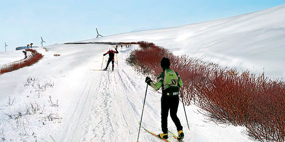
The future of Fresh Kills: cross-country skiing on half a century's accumulation of garbage. Rendering courtesy of Field Operations.

Sullivan's article is also rich with garbage trivia: the Sanitation Dept. processes 312 gallons of liquid dump excretions from Fresh Kills every minute. "Henry David Thoreau, living in Staten Island while trying to get freelance writing work in Manhattan, used to walk onto the marsh island in Fresh Kills to dig arrowheads, 'the surest crop.'” And the urban archaeological artifacts buried there include "a million dollars’ worth of cocaine and heroin accidentally lost in a garbage scow (1948); eight capsules of radium accidentally taken from a doctor’s office (1949); a leg, possibly from a gangland-style hit (1974)."

Read the whole story here, or find out more about Fresh Kills Park from the official City website.

Elsewhere, the Times Escapes section ran a story last week on inner-city hiking trails with city skyline views. The article included trail recommendations in DC, Pittsburgh, Philly, NYC, Hartford, Boston, and Portland. All good places to walk off your Thanksgiving meals.

Friday, November 21, 2008

Red States and Red Clay

Thanks for all of the links and compliments on the Black Belt post. It's been really gratifying to watch all of the pings come in from blogs all over the world, and with such kind compliments, too. I certainly thought it was neat, and I'm glad so many others agreed.

To those of you who are new visitors, my goal with this blog is to discover and write about the complex relationships between ecology and society. The maps of black belt soils and voting patterns were a particularly elegant and striking example of the sort of geographic connections I'm fascinated by. If you liked that post, you should also check out Portlandhenge, the Downtown Portland Glacier, From Swimming Pools to Vernal Pools, and The ExxonMobil Arena/Disaster Shelter.

Red soil in red counties: Commenter Michael, in the Black Belt post below, pointed out that "as you travel into the politically red areas, it's also literally red, as river sediments give way to red clay. My guess is that the red dirt isn't nearly as good for farming."

I did some background research on this and found that it's true. Actually, the black belt itself features a good deal of red clay, but it's underneath a surface layer of rich, black and loamy topsoil. The photo at right shows a sample of "Bama soil," the official state soil of Alabama. Note the thinner layer of black soil on top of a thicker layer of red, iron-rich clay.

Clay soils are typically the remnants of ancient marine sedimentary deposits, so naturally, there's a lot of clay in the Black Belt and just to its south. But this essay from the Alabama Dept. of Conservation explains that black belt soils have a thicker layer of black, more fertile topsoil because of its chalk content. The chalk fostered prairie grasses, which, over millions of years, accumulated into a dark, nutrient-rich topsoil. South of the Black Belt, where the Cretaceous seas were deeper, there's less chalk. Which means less fertile soil. Which means they supported fewer antebellum slave plantations. Which means more Republicans live there today.

But their gardens are probably lousy.

Monday, November 17, 2008

The Black Belt: How Soil Types Determined the 2008 Election in the Deep South

Edit: credit for the original insight on the cotton-electoral connection seems to belong to Allen Gathman, a biology professor at SE Missouri State University. The Pin-the-Tail blog referenced previously seems to have picked it up later and failed to attribute the source; the post below has been corrected accordingly.

This is not a political blog. However, this is a story I couldn't pass up: the story of how voting patterns in the 2008 election were essentially determined 85 million years ago, in the Cretaceous Period. It's also a story about how soil science relates to political science, by way of historical chance.

It's also a story best told with maps, beginning with this one:


This is the map showing county-level election results in the southeastern USA, courtesy of the New York Times website. Most of these are "red" states, but the county-level detail shows an interesting phenomenon: a crescent of blue that runs in an arc from the Mississippi River floodplain to central North Carolina. This had struck me as curious when I saw it after the election, but I regret that I didn't investigate it further until the story was explained over the weekend on the Strange Maps blog.

Allen Gathman, a biology professor in Missouri, had also seen the pattern and recognized it as a function of land use in the deep South. He posted the electoral map above alongside a map of cotton production in 1860: sure enough, the "blue" counties correlated with cotton production in the slavery era. Here's a mash-up of the two maps from Strange Maps contributor Mark Root-Willey:


Each dot in the overlay map represents 2,000 bales of cotton production in 1860. Recall from your American history class that cotton production, a high-value but labor-intensive industry, was one of the prime economic reasons why Southern states chose to maintain the institution of slavery instead of maintaining the Union.

Fascinating stuff, but these maps reminded me that I had seen a similar pattern before, in satellite maps like this one:


View Larger Map

There's that crescent again. A closer look reveals that the lighter-colored band in the satellite image consists mostly of agricultural fields. Here's a detail of Noxubee County, one of the blue counties in eastern Mississippi that's located in the middle of the crescent:


View Larger Map

It turns out that this crescent actually has a name: the "Black Belt," a name that refers both to the area's racial demographics and to the rich, loamy soils that were ideal for cotton crops.

Allen Tullos of Emory University has an excellent essay on the Black Belt that's available online from the Southern Spaces journal. His article observes that
Half of Alabama's enslaved population was concentrated within ten Black Belt counties where the exploitation of their labor made this one of the richest regions in the antebellum United States.
Tullos's essay also includes a quote from Booker T. Washington, who gave this assessment of the Black Belt in 1901:
"I have often been asked to define the term 'Black Belt.' So far as I can learn, the term was first used to designate a part of the country which was distinguished by the colour of the soil. The part of the country possessing this thick, dark, and naturaly rich soil was, of course, the part of the South where the slaves were most profitable, and consequently they were taken there in the largest numbers. Later, and especially since the war, the term seems to be used wholly in a political sense - that is, to designate the counties where the black people outnumber the white.
A hundred years later, the "black belt" still contains a high concentration of African Americans, who, as a demographic group, voted overwhelmingly in favor of Barack Obama.

To review so far: the blue counties can be explained by the black population, whose ancestors were brought there because of white supremacy, and black soil.

But how did the soil get there, and why is it in this unusual crescent-shaped band? In an essay on the area's ecology, Joe MacGown, Richard Brown, and JoVonn Hill of the Mississippi Entomological Museum write that "the entire region is underlain by Selma Chalk formed from Upper Cretaceous marine deposits. Depending on the exact consistency of the parent material, the chalk weathers into a variety of soil types which supports a mosaic of habitats ranging from prairie to forest." Here's their map of this geological formation - look familiar?


One last map to bring it full circle, from blue counties, to ancient blue seas. Below are two maps of North America in the late Cretaceous Period, made by Professor of Geology Ron Blakey at the University of Northern Arizona. The map on the left shows the South during the early Cretaceous, about 115 million years ago, and the map on the right shows the South during the Late Cretaceous, about 85 million years ago. These shallow, tropical seas, teeming with marine life, laid the deposits that would eventually become the rich "black belt" soils. Note how the crescent of cotton farms in 1860, and of Democratic-voting counties in 2008, also follows the crescent of these ancient shorelines:


For further reading:
Allen Tullos, "The Black Belt." From Southern Spaces, April 2004.

Joe MacGown, Richard Brown, and JoVonn Hill, "The Black Belt in Mississippi." From the Mississippi Entomological Museum.

Ron Blakey, "Paleogeography and Geologic Evolution of North America: Images that track the ancient landscapes of North America"

Friday, November 14, 2008

Climate Change: a Monroe Doctrine for the Arctic

From Der Spiegel:
Ironically, while the world worries about climate change, global warming is triggering great hopes in Greenland. If the Arctic waters were truly ice-free in the summer in five to 10 years, which would be significantly sooner than previously feared, this could be good for Greenland -- at least economically.

The port of Qaqortoq in southern Greenland. From Der Spiegel.
Almost 200 years after the Monroe Doctrine, climate change is making the relationship between the Kingdom of Denmark and its arctic colony about as substantial as the melting pack ice. Geographically, Greenland (technically a "semi-autonomous republic") is the largest remaining European colony in North America. Its predominantly Inuit population drives a hardscrabble economy: Greenland exports lots of fish, and it imports lots of alcohol.

But with melting ice and increasing global demand for natural resources, Greenland looks set to storm into the global economy. The island stands to become a sort of Arctic Dubai by exploiting tremendous offshore oil reserves, which, in turn, will help accelerate the disappearance of the ice that's holding it back.

Thursday, November 06, 2008

The Pittsburgh Menagerie


A flock of wild turkeys (crossing the street below the bridge) in a ravine of Pittsburgh's Schenley Park. Photo courtesy of Timothy Wisniewski.
From the Pittsburgh Tribune-Review, zoologist Mark Browning lists some of the wildlife sightings he's had in the Steel City: bobcats, coyote, ravens, beavers, red foxes, herds of deer and flocks of wild turkey, bald eagles, and river otters.

Pittsburgh is characterized by steep hillsides (hence the city's famous inclines) and undeveloped ravines, which act as wooded wildlife corridors for critters moving into the city from the rural outskirts. Since passage of the Clean Water Act, animals like beavers, otters, and bald eagles have moved in to reinhabit the banks of the Allegheny and Monongahela Rivers. As in any city, humans' backyards, garbage, and feeders, plus an absence of predators, attract other mammals, like rats, coyote, and deer.