Showing posts with label inner-city wilderness tours. Show all posts

Monday, January 20, 2014

The Grand Canyon of Westbrook

The Grand Canyon of Westbrook is a large volume of negative space out behind the Travelodge (the landmark visible in the photo below, on the Canyon's north rim). I've been past it hundreds of times in my lifetime, but unless you walk out the railroad tracks to stand on the edge, it's easy to miss. The shopping centers and four-lane arterial roads that surround it do a remarkable job of obscuring the city's biggest hole in the ground.


Some online research reveals that the rock of the quarry is gneiss, rock that originally formed as marine clay and slate about 450 million years ago. It was the Ordovician Period, and the mud that would eventually become coastal Maine was accumulating in a shallow subtropical sea surrounding a chain of volcanic islands in the southern hemisphere.
450 million years is a long time. Enough time for seafloor mud to harden into slate, then for that slate to fold onto itself and plunge miles deep into the earth while brand-new Appalachian Mountains rise to the height of Himalayas near the equator, plus enough time for those Himalayan-sized mountains to wear away to White Mountain-sized nubs.
450 million years is nine million times longer than the amount of time it took Blue Rock Industries to make this hole. But now that we're thinking in terms of hundreds of millions of years, in terms of rocks that drifted halfway across the globe and sank four miles under long-gone mountains and resurfaced here, it doesn't seem like such a big hole any longer, in the grand scheme of things, does it?

Just a very temporary divot on a landscape even more temporarily known as "Westbrook," "Maine."

Tuesday, December 10, 2013

Borderlands

I took a walk this weekend out to Westbrook, the city adjoining Portland to our west. Westbrook's Main Street is less than five miles from downtown Portland, but these are small cities and along the borderlands between them there's a still mostly empty landscape of meadows and depopulated infrastructures.

From the edge of Portland I followed the old Cumberland and Oxford Canal, which for a few years in the mid-nineteenth century used to ferry lumber from 20 miles inland to the ocean. It's mostly silted up now, but its towpath is still in use along the edges of the Fore River marshes as a walking trail.


The canal's on the left; the Fore River's on the right. The high-voltage power lines on the right lead eastward towards a substation near the bus terminal, where the power gets stepped down to lower voltages and fed into local delivery lines along city streets. Westward, the same lines lead to higher-voltage lines on the New England bulk power transmission grid. Not far from the junction is the metropolitan area's largest power plant, which burns fracked natural gas delivered from Pennsylvania and Texas via the state's primary north-south gas pipeline.

Under the power lines are the railroad tracks of the old Portland and Ogdensburg line, which put the canal out of business as an overland connection between Portland and Montreal. Over 150 years later the railroad is still less abandoned than the canal is, but only this short section between Portland and Westbrook is at all active. Give it a few more decades and there might not be much difference any longer.

These days virtually all of the cargo between Portland and Quebec is crude oil that goes through in two underground pipelines. Those pipelines also run through these marshes at the head of the Fore River.

And speaking of abandoned infrastructures: on the other side of the marsh I bushwhacked northwards through the woods for a while and found the city's "technology park" (previously written about here). The city finally wrote a seven-figure check to cut down the woods and build a short cul-de-sac here this past summer. And now, just look at all the jobs:


From there I picked up the right-of-way of the oil pipeline back towards the railroad tracks near the Turnpike. Until the Turnpike, the infrastructural routes I'd encountered all trended east-west, from the coast into the mountains. The Turnpike is oriented north to south. Our 19th-century infrastructure treated Portland as a hub of trade to which rural hinterlands could be connected; our 20th-century infrastructure generally treats Portland as the hinterland that needs to be connected to Boston.

There are some decent and uncluttered tags under the Turnpike overpasses here.


A few yards further and I had crossed over into Westbrook, where the silos of a big quarry and asphalt plant loomed over the tracks. It was there that I found the most impressive of all the day's abandoned earthworks — the Grand Canyon of Westbrook. I'll save it for the next post later this week.

Wednesday, May 01, 2013

Fossil fuels bike tour

Late last fall, builders wrapped the construction of the new Veterans' Memorial Bridge, which spans the Fore River in the western reaches of Portland harbor. The project included a beautiful new bike path between Portland and South Portland, and this evening I went out to ride it for the first time this spring.


The old bridge (recently dismantled) used to run through the center of the photo above, immediately parallel to the railroad bridge at left. Its former course is now an empty lot with some remnant orange construction fencing. The coastline here is full of concrete riprap and odd tidepools formed from 20th-century construction debris.


Nearby on the Portland side of the bridge is Merrill's marine terminal, which transfers miscellaneous cargoes between ships and the railroad.  There's usually a large pile of coal here, but not much of it remained this afternoon. Maine has no coal-burning power plants, but at least one of its large paper mills still burns coal to fire its boilers.


I dig the interpretive signage.


Calcium carbonate, according to Wikipedia,  is mainly used in construction "as an ingredient of cement or as the starting material for the preparation of builder's lime by burning in a kiln." But these tank cars are more likely headed to one of Maine's paper mills, which are increasingly specializing in value-added coated paper products. Ground calcium carbonate can be used as a filler to substitute for wood fiber, and can also replace kaolin in glossy paper production.

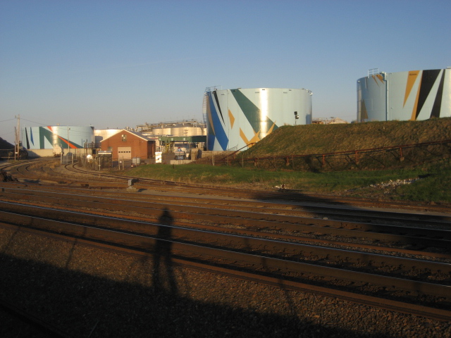
A few years ago, some local philanthropists decided that they needed to beautify the oil tanks with art, and hired a Venezuelan-born artist to design the patterns. I admit I kind of like it, even though I blanch at how much money they spent on it. 


And I'm put off by the a strange impulse to cover the oil tanks in expensive sanctioned art. I'd like to hope that it brings more attention to the oil tanks and makes passing motorists think about their dependence on the global petrochemical industry. But I think most of the wealthy donors are hoping that the paint job will obscure the dirty truth.

On a bike, though, you don't just see the tanks — you smell them, too. A volatile organic bouquet of benzene and sulphates.

A bundle of pipes lead from these tanks to a wharf on the waterfront, where a fuel barge was docked this evening. Similar barges often can be seen refueling tanker ships in the harbor with bunker fuels — the cheapest and filthiest of oil products, so dirty that they generally can only be burned at sea, outside of state and national jurisdictions. A string of oil-containment booms snake out from the wharf's pilings.


For all the fossil fuels on display here, the ability to see them on foot, or on a bike, is a positive development. The new bridge replaces one that had been built in the mid-1950s and designed as a freeway spur. It had one narrow, crumbling sidewalk that dead-ended at a freeway interchange.

Thanks to extensive local activism, the new bridge includes a well-lit bike path, and a lower speed limit and narrower lanes. The freeway interchange on the South Portland side has been  narrowed to a bottleneck where it meets the bridge, in order to force car traffic to yield to bikes and pedestrians.


I like to think how we forced motorists to sacrifice a second or two on their drives across the harbor in order to make the bridge a friendlier place for those of us who prefer not to burn oil. Though I suppose this also means that a few motorists will live longer by not dying in car accidents, only to burn more oil in their old age.

Thursday, March 01, 2012

High-Rise Forestry

This pair of luxury housing high-rises under construction in Milan includes beefy cantilevered balconies that have been designed to support hundreds of fully-grown trees and shrubs.

Architect Stephano Boeri boasts that the project "is a model of vertical densification of nature within the city." The trees that will be suspended off of its balconies are equivalent to a hectare's worth of flat-land forest, while the homes inside the buildings represent five hectares' worth of single-family homes in the Italian suburbs.

It's called Bosco Verticale, or Vertical Forest.

These construction photos are by Daniel Iodice, and come from the Stephano Boeri Architetti website:

And a close-up of the tree boxes:


Here's the architect's vision of how the buildings will look when complete:

The plantings, which will include holly oak, European wild pear, and a mix of shrubs like Cain Apples and hawthorns, seem to have been chosen for their tolerance for constrained soil conditions and for their ability to improve the environmental quality inside and around the towers — shading the windows on hot summer days, insulating the apartments from city noise and particulate pollution, and filtering the apartments' grey water.

I first saw this project on the Green Futures blog, which included this critique:
Alexander Felson, Director of the Urban Ecology and Design Laboratory at Yale University, agrees that “there will potentially be microclimate and air particulate removal benefits”, but warns that the “overall energy required to construct a building that would support both trees and the wet weight of soil” places some serious question marks over its overall sustainability. He favors a more modest approach focusing on green roofs.
True, all that beefy steel and concrete required to hold up trees on an Italian balcony probably required the environmental sacrifice of a good chunk of China.

Still, I think Dr. Felson is missing the point (maybe he just can't see the forest for the trees?). This is a luxury high-rise, after all. While the architect Boeri is clearly interested in sustainability, he's also interested in creating a nice place to live for wealthy Milanese city-dwellers who can pay his commission. There are lots of luxury high-rises — the vast majority of them, actually — that blow their budgets waste construction material on much more masturbatory design flourishes.

What I find most interesting about these buildings is their approach to re-introducing wild nature into the city. I write about that idea often on this blog, but this project takes it to a new level (literally) by marrying a forest with a skyscraper. It's not merely creating a park that's geographically delineated from the rest of the city: it's integrating a forest with one of our most anthropocentric infrastructures: a high-rise apartment building.

That's pretty cool, not just for the people who live there, but for everyone in Milan who will be able to look at a vertical forest in their city's skyline.

Notwithstanding the technical questions of the construction project's sustainability, the buildings still presents an extremely bold vision of a sustainable city — a city in which nature is prominent and integrated into daily life.

Tuesday, January 17, 2012

Houston Is Weird: David Adickes's Giant Presidents

The first time I visited to David Adickes's presidents was during my first-ever trip to Houston in 2004, when Jess was trying to disabuse me of my Yankee prejudices against the place. It was an eerie, muggy night with lightning flashing on the horizon. We got lost for a while among huge silent grain elevators and half-abandoned warehouses near the city's main east-west railroad line, but Jess wouldn't tell me what we were looking for, insisting that it was a surprise.

Then we coasted down a dead-end street and through an open chain-link gate, and saw this:

Left to right: Martin Van Buren, Barack Obama, George Bush Sr., Lyndon B. Johnson, and others (back in 2004, of course, the bust of Barack Obama hadn't been made yet).

A field of gigantic presidents' heads looming in the hazy yellow light of the city, with a distant thunderstorm approaching over the city's suburban prairies: that was an experience I won't soon forget. I moved to Houston a few months later.

Lincoln, Jackson, and Theodore Roosevelt.

You know the "Keep Austin Weird" bumper stickers? Like saving the whales or supporting our troops, it's a halfhearted expression of nostalgia for a condition that's long been on the wane. Houston doesn't need that kind of bumper sticker, because Houston just is weird – though not in the cute ways that people romanticize. There are inflatable gorillas on top of freeway car dealerships, and ubiquitous faux-Mediterranean parking garage/condo buildings, and the flying cockroaches.

Because Houston is so sprawling, it has plenty of room for relatively ordinary people to do weird things on a grand scale, and that's exactly what David Adickes does. He's probably best known for his 70-foot statue of Sam Houston, looming over Interstate 45 about 60 miles north of the city.

Adickes makes cheap concrete sculptures on a monumental scale. His art is quintessentially Houstonian: campy, favoring quantity over quality, and scaled to a freeway audience driving 70 miles per hour. He's purchased additional real estate along I-10, possibly the city's busiest freeway, to become a roadside permanent collection for his sculptures, including a 30-foot tall representation of the Beatles and a huge "We Love Houston" sign.

In a 2004 newspaper article, he said, "the endless road through Houston is filled with a lot of junk on both ends. This will offer a little relief." Or at least some slightly different junk for people to look at.

Until that roadside attraction opens, the sculptures are in storage in a big fenced yard next to Adickes's studio. Personally, I think it's a much cooler place to see them – away from the freeway, you can enjoy them at a leisurely 2 miles per hour, and finding them feels like a discovery. It feels like wandering through a Titan grandmother's knick-knack drawer.

Visiting the presidents' heads make for a good bike ride. They're just a couple of blocks south of the very pleasant Heights Bike Trail, which extends northwest from downtown into the heart of the Heights neighborhood. As you're heading west from downtown, the bike path crosses White Oak Bayou, goes under the freeway, and enters a residential neighborhood. From there, you can take one of the side streets to your left to Summer St., then follow Summer to the end, It's about 2 miles from downtown, an easy 10 minute bike ride. You'll know the place when you find it. I mean, look, the heads are even visible from space:


View Larger Map

Sunday, June 05, 2011

A Self-Reliant Way to Walden

As noted last week, the preferred means of attaining transcendental enlightenment at Walden Pond is by burning petroleum to drive 70 miles per hour down the Concord Turnpike, just a few minutes past the corporate office parks of the 128 corridor.

Thoreau preferred to walk there, of course, from his family home and business in downtown Concord. But as Robert Sullivan discovered and reported in his book The Thoreau You Don't Know, most modern-day Concordians will tell you that it is now impossible to cover the 1.6 mile distance on foot, and will insist on giving you driving directions.

However, if you are lucky enough to have legs strong enough to withstand 30 minutes' worth of movement at an easy pace, it can be done! And so this post offers detailed walking and bicycling directions to Walden Pond from downtown Boston or Cambridge.

To go by foot, take the commuter rail line (which Thoreau rode frequently) from North Station to Concord village. Then head southwest on Thoreau Street, past the Starbucks and the strip mall parking lots. After 10 minutes, turn right on Walden Street, passing Concord High School (you're halfway there). Climb a short hill and wait for the walk signal to make your way safely across the four-lane Turnpike, then take the trail into the woods, past the site of Thoreau's cabin, to the shore of Walden Pond.

Alternatively, you could ride your bike, which makes for a great day trip and lets you take in a couple of good rest stops en route to Concord.

From downtown Boston, there are two good ways to bike to Walden Pond: via the Minuteman Bike Path, which roughly follows the course of the Battles of Concord and Lexington, or by way of Trapelo Road, which is a more direct route through Belmont, Waltham, and Lincoln, but also has more traffic and hills. Personally, I like to go out on Trapelo Road, stopping by the Gropius House on my way out, and come back in on the flat Minuteman Bikeway at the end of the day when my legs are tired.

Either way, you'll need to get through Cambridge first. If it's Sunday, you can weave footloose and fancy-free through the four lanes of Memorial Drive, which is closed to cars on summer Sundays until 7 pm between Western Avenue and Mt. Auburn Street.


At Mt. Auburn Street, either make your way north along the edge of Fresh Pond to get to the Minuteman, or grit your teeth a few blocks through heavy traffic to get to Belmont Street, which turns into Trapelo Road.

Belmont is "thickly settled."


On the other side of Route 128, Trapelo Road enters Lincoln, one of those fancy suburbs where abundant conservation lands clearly serve the dual purposes of maintaining a nice view for wealthy residents while also excluding the condo-dwelling hoi polloi from becoming their neighbors. Notwithstanding the elitism, it's a nice place to ride bikes on shady roads.

On the other side of Lincoln's main intersection, Trapelo Road turns into Sandy Pond Road. You'll pass by the Decordova Museum and Sculpture Park. If you enjoy your art in a setting of overwhelming privilege and cultural homogeneity, it's worth a stop. When we visited, though, we got passive-aggressively talked to for not paying the car-parking fee (because we were on bikes, a "problem" that the Decordova management apparently isn't accustomed to).

Performance art concept: get a crew together to visit the Decordova on foot or by bike, and see how long you can avoid then Gulf oil-funded security detail.

A better place to stop lies a mile or so further down the road. Passing by the Decordova, you'll take a left onto Baker Bridge Road, where, in an old orchard on the left side of the road, you'll pass Walter Gropius's house, now a publicly-accessible historic site owned and managed by Historic New England.

Gropius was the founder of the Bauhaus, and designed this house in 1938, when he came to Massachusetts to teach at the Harvard Graduate School of Design. It's a small and simple dwelling that fits in unassumingly with its rural surroundings (unlike most of its neighbors), and the home's caretakers have preserved the family's possessions, including a lot of original Bauhaus furniture. Tours run hourly until 4 pm, Wednesday through during the summer.

The Gropius house is just a mile away from the main park entrance to Walden Pond - Gropius probably walked there often, and it's interesting to think about the parallels between Walden and the Bauhaus philosophy (maybe a subject for a future post).

At the end of Baker Bridge Road, take a right on Concord Road, and after half a mile further, you're at Walden Pond.

With stops, the bike ride takes 2 to 2.5 hours. On the way back, continue northward on Concord Road to make the 1.5 mile trip into Concord village (where there's ice cream), then take the Reformatory Branch Trail towards the Minuteman in Bedford. With flatter terrain and fewer stoplights, the trip back to the Alewife T station takes about 90 minutes.

I swam in Walden Pond last weekend; the water was refreshing and not too cold. If you're in Boston, it's not hard to get there. Go visit!

Tuesday, May 31, 2011

Walden

While in Boston over the weekend, we took our first swim of the summer in Walden Pond, the famous suburban retreat where Henry David Thoreau lived for two years.

Walden was never a wilderness - even when he lived there 150 years ago, it was still within a 30 minute walk of Concord's busy downtown, where Thoreau managed the family's pencil-manufacturing factory. The commuter rail line that skirts the western edge of the pond today was still there in Thoreau's time (he'd often walk along it as a shortcut from his cabin to the town).

But, inspired in part by Thoreau's writings, people have changed the woods around Walden tremendously in the past century and a half. Americans following Henry David's suburban impulse ("I have, as it were, my own sun and moon and stars, and a little world all to myself," Thoreau bragged in a chapter of Walden titled "Solitude") have transformed Concord from a small agricultural and manufacturing center into a convenient bedroom community halfway between Worcester and Boston.

Three miles east of Walden Pond, modernist cubicle farms for software and pharmaceutical companies crowd along the Route 128 corridor, surrounded by greenery designed to be enjoyed at 55 miles per hour.

From there, a four-lane expressway, the Concord Turnpike, runs within a hundred yards of Thoreau's homestead site. In the time it took him to make his daily 2-mile walk to Concord, modern Thoreauvians can drive themselves all the way to Logan Airport (albeit with less self-reliance).

The road goes two ways, of course, which means that Walden Pond has also become an extremely popular destination for anyone in the metro Boston region who wants to live deliberately and front only the essential facts of life for a few hours after a rough day of shopping at the nearby Burlington Mall.

The state has gradually tried to buy up the land around Walden Pond to turn it into a state reservation. Still, in doing so, the remaining privately-owned parcels nearby have become increasingly valuable as tourist traps and highway rest stops, making additional land conservation asymptotically difficult.

And as a public park, several acres of Walden's former Woods have been cleared to make way for parking lots, a replica of Thoreau's cabin, and the "Thoreau Society Shop" (Thoreau's famous quotation on poverty - "Do not trouble yourself to get new things, whether clothes or friends... Sell your clothes and keep your thoughts. God will see that you do want society" - graces the shop's best-selling t-shirts).

A large bathhouse overlooks a tiny beach on the eastern end of the pond near the parking lots and souvenir shop. The spring-fed pond itself is facing serious erosion problems in the face of all the foot traffic and bootleg sunbathing clearings on every shore, and the state has built a long concrete wall to keep the land nearest the beach from sliding into the pond:

The pond's circumferential footpath in many places runs within inches of the water, compacting the forest soils and making it difficult for plants to take hold and establish their natural filtration functions.

Thankfully, the agency in charge is taking a more aggressive stand against erosion, and erecting fences that keep people from treading on every inch of shoreline. The conserved forestlands that surround Walden Pond do a good job of filtering out the oil- and pesticide-soaked runoff pollution from surrounding freeways, parking lots, and McMansion developments, and so Walden Pond itself is remarkably clean, in spite of its metropolitan surroundings. It's one of my favorite swimming holes anywhere - and I say this as a connoisseur who lives in a place with a bounty of swimming holes.

In a follow-up post tomorrow, I'll write about one of my favorite Boston bike rides: downtown to Walden Pond in about 2 hours, which makes for an ideal summer day trip.

Friday, July 02, 2010

In Seach of Moosey Paradise: A Walk Along Portland's Inner-City Wildlife Corridors


The big news here in Portland yesterday was a young bull moose who had wandered into Deering Oaks Park, a formally-landscaped open space in the central city. Just like the opening credits of Northern Exposure, but with more spectators.

According to reports, the animal took a dip in the park's pond, where it attracted a small crowd of onlookers, as well as the city's police department and a state game warden, who were concerned about how it would cross I-295 on its way out of the city. One of my favorite details of the story is how they were going to shoot the animal with a tranquilizer, but the warden's gun jammed just when she got a clear shot. Apparently Portland's big-game armory has suffered from infrequent use.

It ended up taking the Forest Avenue underpass, crossing one of the city's busiest streets twice, then escaping through the University of Southern Maine campus. It was later spotted at Chevrus High School, located in an inner suburban neighborhood, before it made its way west through the woods in Evergreen Cemetery. The animal was reportedly exhausted, but unscathed.

This isn't the first time a young bull moose has appeared in downtown Portland. A few years ago, police shot one in the middle of the city's Munjoy Hill neighborhood - an even stranger place to see such a huge animal, since it lies at the end of a peninsula, cut off from the mainland by a freeway and the city's central business district. That was also early in the summer, a time of year when juvenile males tend to strike out on their own and take risks in pursuit of their own territory.

These moose that wander into the city obviously have no conception of where it was, just a sense of hope that, on the other side of this neighborhood, it might find a big-enough block of swampy woods with a small surplus of female moose. I'm reminded of how deer and other mammals came to populate islands far from and out of sight of the mainland, swimming for hours on a vague scent, with no way of knowing how much further land would be, or whether they might drown in the crossing. At the risk of anthropomorphizing, I'm impressed at this moose's sense of adventure - its willingness to take big risks to find a great new place.

This kind of exploration is hard to come by for anyone who actually lives in and knows the city. But the moose's path in and out of Portland seems to have gravitated towards the city's remaining blocks of undeveloped land and forested parks - and the places where a moose would feel most at home happen to be the kinds of places I most enjoy exploring myself.

Because there aren't any public reports of the moose before it was sighted in Deering Oaks Park, it's hard to tell how this particular moose got into the city, but I suspect that it either came in the way it left, through Evergreen Cemetery, or it ventured in along the banks of the Stroudwater and Fore Rivers. Here's a map:


Although Portland is on a peninsula, there are two large blocks of wildlands on its fringes that extend towards the central city. To the south, critters like deer and coyotes regularly migrate into the city along the Stroudwater River, which is surrounded by a large block of swampy, undeveloped woods, as well as several farms and golf courses. The Maine Turnpike, probably the biggest barrier for critters trying to get into the city (it's the red-dashed line running across the map above) flies over the Stroudwater on a wide bridge, which makes it easy for critters (and people - this is roughly the path of the Stroudwater Trail) to cross under the highway:


On the other side of the Turnpike, just north of the mouth of the Stroudwater, there's the Fore River Preserve, a former Maine Audubon property that occupies the headwaters of the Fore River along with acres of marsh and forested uplands. From the Preserve, a moose bound for the city could walk through the sparsely-populated neighborhood between the Fore River and the railroad tracks, cross under I-295 at the bridge, and then follow an abandoned railway into Deering Oaks, without seeing a human soul.

Alternatively, a critter could cross the Turnpike at one of two other Turnpike underpasses: one at Warren Avenue, a relatively rural-feeling road that cuts through an industrial area, and one where the Presumpscot River passes under the Turnpike in the city's northernmost reaches. From either of these options, a moose could cut through the thin patches of woods between houses in the city's low-density outer suburbs, before reaching the the Evergreen Cemetery. While the front of the Cemetery, along Stevens Avenue, is highly landscaped, and doesn't offer much cover for critters, the back of the Cemetery is a huge, wild forest that extends almost all the way to the Turnpike. Better still, right across Stevens Avenue from the Cemetery is Baxter Woods, a forested city park, which itself is just a skip across a busy road and railroad tracks to a smaller tract of woods around the new Ocean Avenue School. From there, its just a matter of trespassing through some inner-suburb backyards to get to the parklike University of Southern Maine campus, which is right across the freeway from Deering Oaks Park. The moose yesterday opted to take a detour to the north to visit Chevrus High School, but this roughly describes his escape route.

By coming into Portland, this moose has demonstrated to us an inner-city bushwhacking course through the wildest remaining areas of our city. While I've hiked portions of this itinerary before (such as the Stroudwater Trail, which I described here), I've never tried to do the whole thing in a day, as this moose did. But I think it would be fun to try.

Saturday, April 24, 2010

Safari 7: a wilderness tour of Queens


During a few days spent in New York, I had a chance to briefly visit the Safari 7 Base Camp, set up in Grand Central for Earth Week.

Safari 7 is pretty much exactly what I have been thinking about doing ever since I worked as an Urban Park Ranger a few years ago in Inwood Hill Park: a guided tour that highlights nature and ecology in the places we typically overlook those things. I'm glad that someone actually had the initiative to make it happen. From the project's description:

“The 7 line is a physical, urban transect through New York City's most diverse range of ecosystems. Affectionately called the International Express, the 7 line runs from Manhattan's dense core, under the East River, and through a dispersed mixture of residences and parklands before terminating in downtown Flushing. Safari 7 circulates an ongoing series of podcasts and maps that explore the complexity, biodiversity, conflicts, and potentials of New York City's ecosystems. Tours are available online and can be experienced independently, or in group expeditions and workshops organized by the Safari 7 team.”


The "Base Camp" at Grand Central included an array of gorgeous banners that highlighted things like the aquatic wildlife of the East River, the ecosystems of decomposition at work in the city's huge “cemetery belt,” and the dual role of urban chickens, as food sources and as illegal fighters. The centerpiece of the project is a series of podcasts, short enough to listen to between stops, that describe various ecological phenomena at work at each stop along the line.

Thus, as you ride under the East River, you can listen to a podcast about the tiny island formed from that tunnel's excavation, and learn about the cormorants that nest there. Or hear about the ecology of courtyard gardens in Queens, while you try to get a glimpse of one from the elevated portion of the line.

Over the next few weeks, I plan to write more about those individual podcasts and some of the issues they discuss in more detail. Much of the subject matter isn't unique to Queens - no matter what city or backwoods internet-enabled cabin you live in, there's something for you to learn about your own human habitat. Visit safari7.org to download your own safari audio tour.

Sunday, January 17, 2010

Fort Gorges, Portland, Maine

Here's a post to remind us of the halcyon days of summer.

Fort Gorges (pronounced "gorgeous") is a military installation that dates to the Civil War era, when Portland's harbor was still a strategic military target. It was built more or less in the ocean on top of Hog Island Ledge. Its thick granite walls were built to withstand cannon blasts, which means that they're still in good condition to withstand the constant waves of Casco Bay.


Its construction continued during wartime, but by the time of its completion in 1865, wartime advances in artillery had already made its walls obsolete against the largest cannons. According to this history, "a modernization plan was begun in 1869, but funding was cut off in 1876, with the third level of the fort still unfinished." That third level was instead covered over in a mound of sand, to insulate the interior of the fort and its stores of gunpowder against attack. Today, that mound of sod grows wild with small trees and shrubs.

Inside the fort's walls is a large open parade ground, which is remarkably calm and quiet:


Granite staircases are still in good condition and lead up to the second and third levels, where there are dark tunnels that lead into the pitch-black powder magazines. The northern side of the fort, facing the city, houses the remnant woodwork of the officers' quarters. Walk on the rotted-out floors at your own risk.


During World War Two, the Fort was basically used as a military storage unit, and there's a concrete pad in the central field where sea-mines were allegedly stored. In 1960, the military finally decided that it had no further use for it, and they donated it to the City of Portland, which has maintained it as a public park ever since. The military cleaned out everything that wasn't nailed down or made of granite, with one exception: a large, Civil War cannon on the eastern side of the third level, which was apparently too large to move out and melt for scrap. It's still there, pointing towards the harbor, half-overgrown in grass and daisies:


The Fort is wide open to the public, but you need a boat to get there - some water taxis will take you there at high tide, or you can rent a kayak (as we did) and paddle there from the East End boat launch. It is a pretty excellent adventure.


Friday, December 18, 2009

Using Bikes, and the Social Web, for Environmental Monitoring

MIT's Senseable City Lab has a lot of great projects loosely organized around the idea that a proliferation of cheap sensors, hand-held electronics, and mobile networks offers people more ways to collect and interpret data about their city.

So, for instance, you can embed a cheap radio beacon into a piece of garbage and learn about your city's waste-handling practices (something that city governments rarely like to talk about publicly). The Senseable City Lab did it.

The Lab has a new project they're launching in Copenhagen now, in conjunction with the global climate suicide pact treaty negotiations.

Copenhageners love riding their bikes: it's the dominant mode of transportation in the city, and how 57 percent of workers and students commute. The Senseable City Lab designed a new bicycle wheel (pictured at right) that includes a small electric motor and a 3-speed internal hub, which can transform any bike into a hybrid human-powered/electric bike.

But the hub also includes a GPS unit and an array of environmental sensors that measure levels of pollutants like carbon monoxide and nitrogen oxides, plus temperature and weather conditions. As users ride through the city, they can share their data online with others, and offer real-time environmental transects on a daily basis.


As more users use the wheel and share their data, the city can get a bigger, more complete sense of environmental hotspots, how pollutant levels change over the course of a day, and how to better-manage pollution sources.


I want one. Imagine being able to do your environmental ground-truthing on a leisurely bike ride, or a crowd-sourced revelation of the embarrassing hotspot of volatile organic compounds (from the basement laundry) next to the luxury hotel downtown. I'm hoping these come to the mass market soon.

Monday, May 11, 2009

Detroit, Land of Opportunity, The New New World

Corine Vermuelen-Smith is a photographer who makes me want to move to Detroit:

Her photographs show a city that's reverting back into a frontier: a wide-open landscape of open prairies and land that's free for the taking.


The once-mighty tribes of the Big Three are shadows of what they once were, and their ruins are scattered everywhere. What remains of them is confined to government reservations. Their downfall wasn't smallpox or colonial crusades, but cheap credit and complicity in the SUV trade.


Above: empty-lot farm on Pierce Street.

The Detroit that remains looks like a ruin to most perspectives. But in the images of Vermeulen-Smith (who happens to be from the Netherlands), it looks a lot like a New World. Yeoman farmers reclaim abandoned lots to grow crops, and Detroit's homeless fashion tidy homes in the wilderness to live strikingly similarly as our national demigods, the western pioneers.


The recession is a new American revolution. From these ruins of the old economy grow a new manifest destiny, and it should lend hope for us all that this one will be more frugal, resourceful, and honest than the one we had expected.

Wednesday, November 26, 2008

Inner-city wilderness areas in the news

Some recommended reading:

Robert Sullivan (the same guy who wrote Rats) has an article in New York Magazine about Fresh Kills Landfill, where piles of garbage "about the height of Mexico’s Great Pyramid of Cholula" are currently being repurposed to become one of New York City's largest parks. Here's a post I'd written about Fresh Kills Park last summer.

In an age when our remaining inner-city wildnernesses are usually abandoned industrial or military sites, the new park's designers are hoping to set a new standard in park design: "They would not build a new park on top of an old dump. Instead, they would make the old dump a part of the new park, by acknowledging it, reclaiming it, recycling it on behalf of a modern metropolis."


The future of Fresh Kills: cross-country skiing on half a century's accumulation of garbage. Rendering courtesy of Field Operations.

Sullivan's article is also rich with garbage trivia: the Sanitation Dept. processes 312 gallons of liquid dump excretions from Fresh Kills every minute. "Henry David Thoreau, living in Staten Island while trying to get freelance writing work in Manhattan, used to walk onto the marsh island in Fresh Kills to dig arrowheads, 'the surest crop.'” And the urban archaeological artifacts buried there include "a million dollars’ worth of cocaine and heroin accidentally lost in a garbage scow (1948); eight capsules of radium accidentally taken from a doctor’s office (1949); a leg, possibly from a gangland-style hit (1974)."

Read the whole story here, or find out more about Fresh Kills Park from the official City website.

Elsewhere, the Times Escapes section ran a story last week on inner-city hiking trails with city skyline views. The article included trail recommendations in DC, Pittsburgh, Philly, NYC, Hartford, Boston, and Portland. All good places to walk off your Thanksgiving meals.

Tuesday, October 07, 2008

Urban Hiking: Portland's Stroudwater Trail


A few weeks ago I needed to pick up my newly-repaired camera at the FedEx warehouse out on Hutchins Drive, in Portland's industrial park fringe. So I hopped on my bike and rode to Stroudwater, where Portland Trails maintains a lovely hiking path through the woods next to the Stroudwater River. Following is a photo-illustrated guide to the hike. Since I didn't have my camera until the return trip, these photos are shown in the opposite order in which they were taken.

As the map above shows, the trail begins just off of Congress Street in a subdivision called River's Edge Drive. A Portland Trails sign marks the trailhead. You go down a hill to the actual river's edge, and wind along there just out of sight of suburban backyards. One of the Rivers Edgers has ingeniously appropriated a city sewer vault as a canoe rack. Who cares if your canoe smells a bit like sewage? Especially if you're paddling the Stroudwater, which includes a couple of sewer overflow outlets and cow farms along its banks?


Since the trail follows the river, it takes substantially longer to follow its loopy course than it would to walk a parallel route along the road. But soon, the terrain gets hillier as the bank leading down to the river also becomes steeper and the trail diverges from the riverside. Unfortunately, my own hike was too long ago for me to remember many of the trees and forest types I was passing through, but I do recall a lot of hemlock trees in this stretch, in the damper, shaded soils along the riverbank's north-facing slopes.

Fairly suddenly, you'll break out of the darkish coniferous forest into an open deciduous forest carpeted by ferns, and not long after that you'll walk through this clearing:


This is the pipeline corridor of the Portland Pipe Line Corporation, Quebec's primary oil lifeline, which connects tanker ships in Portland harbor to oil refineries near Montreal. So in theory, you could follow this path all the way to Montreal, but you'll have to cross a number of rivers along the way (like the one a few yards to your north here) without the benefit of bridges, and besides, as the signs here will tell you, trespassing in the pipeline corridor is not allowed.

Continuing west, then, you'll soon return to the riverbank by walking along boardwalks in the soggy floodplain. Across the river here is a pungent meadow, where the City of Portland's last resident cows chew their cud in sight of the Maine Turnpike.

The trail soon leaves the floodplain and climbs uphill again, until it reaches another clearing hemmed in by a spectacular wall.


Beyond this wall is an eleven acre parking lot - one of several asphalt plains that surround the UNUM headquarters. On the trail's side of the wall is a small wetland filled with cattails and other grasses that help filter the parking lot's toxic doses of stormwater runoff. Also note the sumac in the left side of this photo - it's a sun-loving pioneer species that's frequently found at the edges of meadows and other disturbed areas in temperate deciduous forests.

You'll barely leave the great wall of parking behind when you arrive at another, louder clearing: the bridges where the Maine Turnpike carries four lanes of freeway traffic over the Stroudwater River.


But as soon as you put the Turnpike behind you, there's a time warp! It seems as though you've stumbled into the early nineteenth century... from every parked car, you expect to see emerging a barrel cooper, or a blacksmith, or a fugitive slave bounty hunter!


No, you're still in the year 2008. But here at the Sturbridge Yankee Workshop, history really seems to spring to life! Inside, skilled craftsmen are practicing a time-honored American tradition: distributing decorative accents and furniture that have been shipped from China.

The trail leaves the Workshop's parking lot and descends to a small parking area at the end of Blueberry Road, which leads back to Congress Street. Continuing along the trail, though, you'll enter the woods again, although a razor-wire fence soon appears in the woods to your left. Beyond emanates a steady industrial thrum:


This is ecomaine's waste-to-energy incinerator, which burns the majority of the Portland region's garbage and uses the heat to produce electricity. This is a place that deserves a blog post of its very own, and I plan to write it soon. As the trail passes opposite the incinerator's huge smokestack, you can find a mysterious PVC pipe emptying a steady drip of unknown liquid onto the trail (the pipe seems to lead straight towards the incinerator).

Past this point, the trail is closed in the winter, since the woods beyond the incinerator contain some of Portland's only winter habitat for white tailed deer. The trail winds through upland forests for another half mile or so and passes a minor power line corridor before reaching Hutchins Drive.


The last fifty yards or so of Hutchins (pictured) are barricaded from traffic and overgrown with ten to twenty years' worth of encroaching plant growth. It's kind of neat to see the forest overtaking the no parking signs and guardrails. Even in the middle of the street, weeds are beginning to take over from widening cracks in the pavement.

The trail continues a bit further on to the Westbrook town line, but this is where I turned around. If you're reading this on the blog, just scroll up and read this whole post backwards to get back to where you started.

Wednesday, March 12, 2008

Revival!

"Long, blue, spiky shadows crept out across the snowfields, while a rosy glow, at first scarce discernible, gradually deepened and suffused every mountain-top, flushing the glaciers and the harsh crags above them. This was the alpenglow, to me one of the most impressive of all the terrestrial manifestations of God. At the touch of this divine light, the mountains seemed to kindle to a rapt, religious consciousness, and stood hushed and waiting like devout worshipers."
-John Muir, "A Near View of the High Sierra"

I took a bike ride around the city this evening to celebrate the newly-saved daylight after work. Right before sunset, I rode through Bayside and found a newly-resurgent Bayside Glacier, bigger and more sublime than ever.


With this winter's near-record snowfall, the glacier - which is in essence a frozen pile of stormwater runoff - has actually spilled over to the vacant block east of Chestnut Street, where a smaller snowfield (foreground above) now grows.


Unlike last winter, this year's glacier has company in the form of new high rises going up one block north on Marginal Way. These projects forebode a time when glaciers will no longer grow here: this week, the city of Portland agreed to negotiate with three developers who intend to replace future glaciers with office buildings and housing.

But before the sun sets and the glacier melts away, this evening there was still time for an urban mountaineering expedition. I chose the easy eastern route.


Above: approaching the summit at 30 feet above sea level. I stopped here to acclimate and snap a photo.

A self-portrait from the summit, looking down the western arête. Luckily I'd brought my bike helmet, just in case I fell into a crevasse.


The steep western face (a technical climb) and the view towards downtown.

For a glimpse of the glacier's near future, check out this May 2007 expedition.