

The Geotaggers' Atlas
On the photo sharing websites Flickr and Picasa, users can "geotag" their photographs with specific longitude/latitude coordinates on a map, as a way of organizing their own collections and seeing other photographers' images of the same neighborhoods.
Geographer Eric Fisher has mined this data using the sites' public APIs to create the "Geotaggers' World Atlas," a collection of maps of 100 major global cities, overlaid with points representing where users have posted their photographs. The resulting images are fascinating, information-rich portraits of the places where photographers (or, more precisely, web-savvy photographers who upload their photos and tag them with geographical data) congregate.
Thus, the map of London shows dense concentrations of photos in the central business district, but also in Greenwich and Canary Wharf (the two blobs near the east side of the map), in Kew Gardens (on the west side), and along the city's principal streets. The banks of the Thames River are clearly delineated as well, and criss-crossed by dense clusters of photographs taken on the city's bridges:

Other maps reveal more about where digital photographers who use Flickr and Picasa are likely to live and hang out. Here's Portland, Oregon, a city I'm familiar with from my college days at Reed College:

As in London, the banks of the Willamette River are clearly delineated in the downtown area, where there's a popular park on the western bank and a bike path on the eastern bank, as are the city's bridges. The horizontal line just south of downtown is the city's new aerial tramway, a photogenic segment of the transit network that connects the riverfront to the Oregon Health Sciences University complex high above in the city's West Hills.
A small knot of photos on the east side of the map represents Mount Tabor Park. Between there and downtown stretches Hawthorne Boulevard, a business-lined Main Street that runs all the way to the Hawthorne Bridge into downtown. You can also make out North Mississippi Ave., plus Killingsworth and Alberta Streets, north of downtown. These neighborhood Main Streets aren't particularly dense areas of the city, nor are they tourist magnets. But they are the business and entertainment districts for gentrifying neighborhoods where Flickr's young, web-savvy users like to hang out and take digital pictures of their friends.
These maps can also say a lot about a city's distinctive way of life. Here's Istanbul:
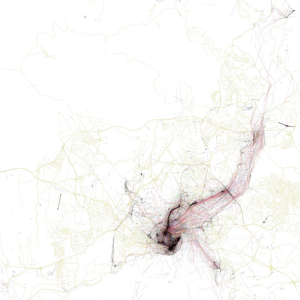
The dense quadrangle in the bottom-center of the photo represents the city's major tourist sites: clockwise from the western corner, they are the Grand Bazaar, the waterfront near the Spice Bazaar, the palace complex, Hagia Sofia, and the Blue Mosque. Extending north from the Spice Bazaar is a dense cluster of photos across the Galata Bridge, up the hill past the Galata Tower, and along the arc of İstiklal Cadessi, a major nightlife and shopping district.
But unlike other cities, Istanbul's map is defined less by streets, and more by the broad waterways that separate its neighborhoods. From the Golden Horn (the central peninsula at the bottom-center of the map) emanates a web of photographs and multiple-exposure photo paths taken from ferries and other boats traveling along and across the Bosporus straits. Clusters along the shore represent ferry terminals at Beşıktaş, Harem, and other neighborhoods. Istanbulites clearly spend lots of time on boats, and like to pass the idle time on the water by snapping photographs.
More recently, Fisher has updated a number of these maps to differentiate photos from tourists and photos from locals (his methodology: if a photo comes from someone who is still geotagging photographs in the same city within 30 days, it qualifies as a "local"). These "Locals and Tourists" maps add another layer of information to distinguish the places where tourists go from the places that locals find to be the most interesting.
Here's New York. Red dots represent "tourist" photographs; blue dots are from locals, yellow dots could be either:

Ellis Island and the Statue of Liberty stand out as bright red clusters in the lower left corner, connected to the red Battery at the southern tip of Manhattan by a dense web of photos from ferry rides. Just to the right is the blue, teardrop-shaped outline of Governor's Island, a newly-opened park that seems not to have caught on yet with visitors, which is itself just above a blue cluster around Red Hook, another neat neighborhood that is definitely far from the tourists' beaten track.
There's a lot of red in midtown Manhattan, especially along 34th Street (the Empire State Building), 42nd Street (with Times Square, Grand Central, and the UN on the East River), around Rockefeller Center, and in the southern reaches of Central Park. Locals predominate along the avenues of the upper west side, in Riverside Park along the Hudson River, in the Lower East Side, and in the Brooklyn neighborhoods of Park Slope, Fort Greene, and Williamsburg, as well as in the old World Fair grounds in eastern Queens. And note the small cluster of red and blue dots around Yankee Stadium in the Bronx (in the upper center of the map) and around the Meadowlands sports arenas over in New Jersey (on the left edge of the map).
And here's San Francisco. Can you spot Alcatraz?
 San Francisco is the center of the metro area where both Flickr and Picasa have their headquarters - apparently a lot of their employees and enthusiasts live in the Castro and Mission districts (the dense blue grids just south of downtown).
What I really like about the Locals and Tourists maps is the possibility of using them as a tourist's guide to un-touristy places. If I were going to Washington, for instance, I might want to cut short the sightseeing on the Mall to check out those blue clusters north of Dupont Circle around Meridian Hill Park, or see what the locals find so photogenic about the Potomac River in Georgetown. The Space Needle is clearly popular among visitors to Seattle, but maybe my time there would be better spent finding out why the locals take so many pictures around East Union and North 45th Streets.
Using the maps this way might be particularly useful in Paris, where there's evidently no shortage of photos of the Eiffel Tower. Parisians seem like the kind of people who'd be a lot more friendly and welcoming to visitors who don't contribute to the mobs around the Louvre and Île de la Cité and are brave enough to venture to the more genuine parts of the city. The 19th and 13th arrondissements look promising.
That said, I've also never been to Alcatraz myself, and I'd like to go. Most tourist destinations attract visitors for good reasons - but these maps demonstrate that there are plenty of off-the-beaten-track neighborhoods that are worth visiting as well.
Maybe Fisher will share his secret coding techniques with the rest of us so we can produce maps of our own - I'd be especially curious to see Locals/Tourist maps of the east-coast Portland, and of Houston.
It would also be interesting to slice this data in other ways, in addition to Fisher's clever tourist/locals divisions. For instance, what if we separated out the photos that were taken on weekends from photos that were taken on weekdays? Or map only photos taken between 9 pm and 3 am, to generate a diagram of cities' best nightlife neighborhoods? You could even go so far as to analyze the light and color balances of these photographs and generate maps of places where people go on gray rainy days, versus places where people go to photograph blue skies, versus favorite destinations on white snowy days.
In the meantime, both the Geotaggers' World Atlas and the newer Locals and Tourists maps are very much worth browsing, although, like me, you may lose hours to scrutinizing the richness of their information.


