Tuesday, September 30, 2008

When "open space" is bad for the environment

In the East End of my hometown of Portland, Maine, the city is now entertaining a proposal to demolish an abandoned elementary school and build new mixed-income housing and a park in its stead.

I'm all for the idea: building forty new, energy-efficient units of housing in an urban neighborhood will reduce households' dependence on oil-burning automobiles for transportation and fuel-burning furnaces for heat. Especially when the families who would live here would otherwise have to drive 20 to 30 miles out into the suburbs to find a home for a comparable price.


As an environmentalist, then, I have to take issue with one major element of the proposed project: the proposal to set aside nearly half of the site for a park.

To be clear: parks are definitely necessary for a successful urban environment. Most parks provide important ecosystem services, like cleaning the air, filtering stormwater, and providing wildlife habitat, in addition to making the city a more pleasant habitat for humans.

But this site happens to be two blocks away from two of Portland's biggest and most successful open spaces already, so the marginal environmental benefit of a new park is pretty small. In comparison, the proposed housing is providing more important environmental benefits: namely, a big reduction in forty households' energy use, and reduced development pressure in Maine's rural suburbs. What if, by sacrificing a portion of the proposed park, we could realize a big reduction in fifty households' environmental impact?

Building more housing on an already-developed site in Portland will also save acres of forest or farmland from being bulldozed into new subdivisions out in the suburbs. In other words, a small sacrifice in open space here would create a substantial net gain in open space regionally. And more housing here would also reduce the amount of public subsidy this project would require, and free up more funds for affordable housing elsewhere in the city.

We need to ask ourselves this: in a neighborhood that already has so much access to parks and open space, should we really be making all of these financial and ecological sacrifices for another patch of lawn?

Wednesday, September 24, 2008

Portlandhenge

As several commenters inferred, the photo in the last post demonstrates the "druidic/pagan significance" (as Turboglacier puts it) of several streets in Portland's West End. Due to their precise east-to-west alignments along the earth's lines of latitude, these streets - Bowdoin, Carroll, Pine, and the appropriately named West - function as an urban Stonehenge during the year's two equinoxes, when the sun rises due east and sets due west.

I've written more about the phenomenon in this week's Phoenix. That article talks a bit about how the Stonehenge effect repeats itself on different streets in Portland in different times of year. For instance, on the winter solstice, the sun rises roughly along the length of Winter Street, as well as Clark, Brackett, State, Park, and High Streets. Other streets, conforming to different grids in the city's neighborhoods, align along sunrises at other times of year, as the angle of the sunset and sunrise (also known as the azimuth) moves from the northern part of the horizon in summertime to the southern part of the horizon in winter.

But the phenomenon is by no means unique to Portland. At the equinoxes, no matter where you are on the globe, sunrises and sunsets shine along streets anywhere the street grid is aligned to the cardinal directions. An excerpt from my Phoenix article:
On the National Mall, the Washington Monument casts its first shadow of the day over Lincoln's statue, then, twelve hours later, over the peak of the Capitol dome. In Houston, the setting sun is blinding commuters on the Katy Freeway. Throughout most of Chicago, people can watch the sun rise over Lake Michigan and set over the prairie.


In other cities, where the street grids are skewed to some other angle, the phenomenon occurs at other times of the year. Manhattan's streets, which are 30 degrees off of the cardinal east/west directions, experience "Manhattanhenge" closer to the summer solstice, when the sun rises and sets in the southeast and southwest, respectively. Pictured is a sunset seen through midtown Manhattan on May 29th of this year (photo credit: David Reeves on Flickr). Here's an excellent article on "Manhattanhenge" from the Hayden Planetarium.

In downtown Philadelphia, the east-west streets follow a heading 9 degrees south of due east. These streets point to the azimuth of sunrise on October 11th this year, then again on March 1 next year. We've missed Phillyhenge at sunset this year - it was on September 5th - but Philadelphians will have another chance to watch the sun drop into the Schuylkill River through the tunnel of downtown's skyscrapers on April 4th, 2009. Here's the almanac data.

I like thinking about how city streets can function as a sort of astrolabe, a way to calculate the date according to the sun's alignment in different neighborhoods. If you live in Portland - or any city with an east-west street grid - get out and enjoy the equinoctal sunsets while you still can. I'll leave you with another photo from the West End's Portlandhenge late last week:

Friday, September 19, 2008

The Autumnal Equinox


More on this subject next week...

Wednesday, September 17, 2008

Bottlemania - 7 pm tonight (and also right now)

Elizabeth Royte's Bottlemania: How Water Went on Sale and Why We Bought It reading is tonight 7 pm, at 1 Longfellow Square ($5 admission). I read it last week, and Mainers should find it especially interesting. Much of her discussion of the issues surrounding bottled water, and the privatization of groundwater resources, revolves around the controversy over Poland Spring's bottling plans in Fryeburg.

Royte will also be reading in about 2 minutes at Portland Public Library's brown bag lunch series in Monument Square. Check it out if you're in town.

Tuesday, September 16, 2008

The Migration Patterns of the Shipping Container

BBC News has bought a shipping container, outfitted it with a GPS Unit, and set it free to track the migration patterns of the 21st century global economy. Here's their description of the project, from bbc.co.uk/thebox:

"We have painted and branded a BBC container and bolted on a GPS transmitter so you can follow its progress all year round as it criss-crosses the globe. The Box will hopefully reach the US, Asia, the Middle East , Europe and Africa and when it does BBC correspondents will be there to report on who's producing goods and who's consuming them."
It's a brilliant journalistic conceit: everywhere the box stops to drop off or pick up a load of cargo, the BBC has a new story to tell about global business.

Moreover, the migratory routes of shipping containers are generally poorly understood to anyone who lacks an insider's proprietary knowledge. As the box moves around the globe, the BBC will track its progress on this online map, along with details about its cargo (so far, it's gone from the port of Southampton in southern England, overland to Scotland to pick up a load of whiskey, and back, by sea, to Southampton, where it's allegedly awaiting a ship to take it to thirsty Asia).  At the end of the year-long project, the BBC and its audience will have a rough map of the game paths of global commerce, and dozens of stories about the businesses, people, and economic conditions that shaped its path.

So, just as conservation biologists attach satellite transceivers to track the migratory routes of things like sea turtles to learn about the animals' habitat needs, habits, and response to things like storms and currents...


... so the BBC project should provide a rough idea of how, and where, products in the global economy respond to supply, demand, monetary crises, resource shortages, and other natural phenomena of international capitalism. I now have yet another website to track obsessively.

Friday, September 12, 2008

Galveston

As a deadly hurricane bears down on the Texas gulf coast, I thought I'd write a requiem post for the 8,000 souls who died in the 1900 storm that devastated Galveston, which was then the fourth-largest city in Texas.

The 1900 storm hit with no advance warning - it was long before satellite tracking, radar, or reliable forecasts (in the absence of professional meteorology, the storm also had no name). Five days after the storm, a Galveston Daily News reporter wrote,
The story of Galveston's tragedy can never be written as it is... But in the realm of finity, the weak and staggered senses of mankind may gather fragments of the disaster, and may strive with inevitable incompleteness to convey the merest impression of the saddest story which ever engaged the efforts of a reporter.

The quote and photograph come from a Galveston Daily News website dedicated to memorializing the 1900 storm.

After the storm, the city participated in a massive effort to raise the elevation of the island's most flood-prone areas, by as much as 16 feet. To me, the raising of Galveston exemplifies Texas's incredible capacity for revival and growth. It was an incredible feat of civic effort and engineering, executed with turn-of-the-century technology.

Entire structures were jacked up into the air and put on stilts:

St. Patrick's Church, Galveston: from the Texas State Library and Archives.

Avenue O residence, Galveston. Note the front stairway suspended in midair. From the Texas State Library and Archives.

Then, massive pipes were laid in the streets, and dredges began to flood the ground beneath the stilts with mud...
Pipelines discharging dredged fountains of muddy fill. From the Texas State Library and Archives.

...until the ground rose up to meet the bottoms of the raised buildings, and the stilts were buried.

Before and after. This photo comes from Pruned.

In the century since, rising seas and geological subsidence have brought Galveston's elevation as much as 2.5 feet closer to sea level. That also brings the city 2.5 critical feet closer to disaster as Hurricane Ike bears down on the barrier island tonight. Worse still, the past few decades have brought intense development of new homes and businesses to the western end of the island, areas unprotected by the city of Galveston's raised grade or seawall.

This storm could be really ugly for southeastern Texas. Let's hope for the best.

Wednesday, September 10, 2008

Alternative energy FAIL

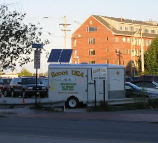
Below is a photo of an electric-scooter rental station located on Commercial Street, in Portland's waterfront tourist district. Apologies for the low photo quality, but the trailer says, "Go Green, Save Gas."
To drive the "green" point home, there is a solar panel. Presumably it's there to recharge the electric scooters. But I can say with some confidence that this solar panel is not charging much of anything, because it's tilted towards the northwest, and here in the northern hemisphere, most of our sunlight comes at us from the south.

I took this photo about two weeks ago and gave Scoot USA the benefit of the doubt for a while. Surely the owner or manager would notice that their expensive alternative-energy investment wasn't pointing towards the sun, right? But after considerable time, the panels haven't budged.

I suspect that the owners are pointing them towards the northwest because that's where the street is: if the panels were actually pointed towards the south, how would tourists walking past be able to tell what they were?

As far north as we are, solar panels generally don't perform very well as a source of electricity. But as billboards selling green snake oil, they're apparently worth the investment.

Monday, September 08, 2008

Elizabeth Royte in Portland


Coming soon to Fryeburg?
Elizabeth Royte, who wrote the world's preeminent field guide to solid waste, Garbageland, is coming Portland, Maine to talk about her new book, Bottlemania, a field guide to the watersheds of the global market economy.

I haven't read the new book yet, so I've got my homework cut out for me. But I have read favorable reviews and learned that a substantial portion of the book focuses on Fryeburg, Maine, where the Poland Spring Aquifer Mining Company is facing some community opposition to its proposals to install new on-shore drilling platforms in the area.

Royte will give two readings: one at the Portland Public Library's free brown bag lunch series, at noon, and another at One Longfellow Square, sometime in the evening, for a $5 admission. More details are and will be at the Rabelais Books blog.

Thursday, September 04, 2008

The Black Cloud: Citizen air-quality monitoring in south central LA


A typical black cloud sensor, sniffing VOCs from a marker.

Over the past summer, high school seniors at L.A.'s Manual Arts High School pored over graphs from environmental sensors like the one above as part of the "Black Cloud Citizen Scientist League," a game designed by Berkeley artist Greg Niemeyer.

Niemeyer and teacher Andy Garcia hid these sensors in various places inside the students' neighborhood where they expected to find big difference in pollution levels: a dry cleaner's, a gas station, a nail salon, and inside the classroom itself. The object of the game, for the students, was to discover where the sensors were - mostly by analyzing the data from the sensors and learning about the factors that influence air quality in their neighborhood.


Sensor output from an Echo Park drycleaner business, showing data on light levels, temperature, noise, volatile organic compounds (VOCs), and carbon dioxide. Image courtesy of Planetizen.

Some of the project's outcomes were surprising. On his blog, Niemeyer writes that the gas station's VOC levels were relatively low: the sensor was placed inside, next to an ice cream freezer, and gasoline vapors rarely reached it. But students also learned that their neighborhood's carbon dioxide levels, at 600 parts per million, were almost twice as high as most places.

Most disturbingly, students learned that their own classroom had CO2 levels around 3,000 parts per million - high enough to cause fatigue and poor attention span in most people. Students responded by opening doors and windows to improve ventilation, and they watched the CO2 levels decline. But the lessons of the classroom's conditions can be applied to the whole city, according to Neimeyer in a blog post he wrote at the project's conclusion:
After 6 weeks of tracking Black Clouds in LA, our observation is that in some places the air recovers, and in others, it gets worse. Recovery happens either because powerful HVAC systems run all night to clear the air, say, in the Metro Transit Authority office building, or because someone put many plants in their space, such as at Machine Project. In places like the Manual Arts High School room p74, pollutants concentrate throughout the week and get barely a chance to clear up during the weekend. If we scale these observations up to the whole city, well, LA’s air does not recover because it moves offshore at night just to move onshore again the next morning. Our conclusion is that we must find ways to let the air recover. We call it eco-fasting. How about not using the car every other day, voluntarily? How about growing plants indoor to clear the air while we’re at work? How about using no electricity all weekend?

The Black Cloud sensors are now monitoring conditions at various locations in Los Angeles's Echo Park neighborhood and around the UC Berkeley campus. Visit the Black Cloud website to look at graphs of current conditions.

You can also read more on Planetizen, where I learned about this project.

Tuesday, September 02, 2008

Portland Combined Sewer Overflow Outlets

Labor Day's come and gone, which means that there are scant opportunities left to enjoy Maine's beaches. The ocean's temperature is at its warmest this time of year, and a stretch of dry weather means that Portland's combined sewers haven't overflowed into Casco Bay since mid-August.

But if we do get any wet weather, you might want to avoid swimming near any of the markers on the map below. These are Portland's combined sewer overflow outlets, where a toxic combination of street runoff and raw sewerage overflow into local watersheds during wet weather (read all the details here):


View Larger Map

Circles on the map are outlets that continue to function as combined CSOs (mixed sewage and street runoff); stars are outlets that only dump street runoff (which is bad enough, but at least the amount of feces in it is limited to that produced by the population of city dogs with irresponsible owners).

Monday, September 01, 2008

New title image

Here's the new title image for the blog, modeled after the National Park Service's "black band" design. The typeface is Frutiger, and a city skyline and rat replace the mountain and buffalo, respectively, in the Park Service's shield emblem.

The full-sized version is now at the head of every page at vigorousnorth.blogspot.com: