Showing posts with label rights of way. Show all posts

Friday, March 05, 2010

The working parking waterfront

Kudos to reporter Tom Bell for bringing attention to the over-supply of cheap parking - on waterfront property, no less, in today's Portland Press Herald. Bell notes that "Until the middle of the last century, when Portland's waterfront was a hub of transportation and fishing activity, the piers were covered with buildings, including warehouses for grain, molasses, coal and wood."

This was the city's working waterfront heritage, which everyone wants to preserve and protect.

However, Bell goes on to observe that "Most of those buildings have been demolished over the years, and today more than three-fourths of the area that could be developed in the central waterfront zone has no buildings. Instead, there is plenty of parking."

It's got some choice quotes, including:
“We don’t have a working waterfront. We have a parking waterfront,” said Don Perkins of the Gulf of Maine Research Institute.
This is kind of a dangerous idea. Portland prides itself so much on its working waterfront - the handful of bait shacks, trawler berths, and chandleries that still remain on the city's piers. Speaking the truth - that 3/4 of the "working" waterfront is really just a big parking lot - really deflates this big source of the city's pride.

Even the hotel and convention business, which is traditionally been seen as a prime economic adversary of marine industrial uses on the city's piers, agree that the acres of empty lots are a blight on the waterfront:

More public transit is the key to eliminating parking lots on the waterfront, said Barbara Whitten, executive director of the Convention and Visitors Bureau of Greater Portland. "A sea of cars," she said, "is not an attractive way to market the waterfront."

Read the full article here.

Wednesday, February 03, 2010

Cities aren't wasting money, they're wasting space.

Portland, like most governments in America these days, is in the middle of a big budget shortfall. They're cutting school programs, raising bus fares, and laying off social workers. The city's main source of revenue is a 1.8% property tax, which is already high by Maine standards - the city can't raise it much further without sending more development and investment into the suburbs, and sending more homeowners into foreclosure.

On the face of it, it looks pretty hopeless. But in fact, City Hall has millions of dollars in costs that, out of pure neglect, it's been hiding off of its balance sheets. They're not in the schools, or in homeless shelters.

They're the opportunity costs of the city's acres of parking lots.

Here's an example - the East End School has a half-acre off-street lot on North Street. It's got gorgeous views of Back Cove and Casco Bay, it's across the street from the community gardens, it's a desirable neighborhood - and we're using this space only 15% of the time, for private vehicle storage during school days. This is self-evidently stupid, isn't it? And yet, there it is.

What if, instead, we made those few drivers park in the abundant on-street spaces on North Street and the Eastern Promenade (or walk, or take the bus), then sold this half-acre on the open market, no strings attached? Even in this economy, such a desirable location would fetch a lot of money - probably at least $400,000, which happens to be roughly 5% of the school system's budget shortfall this year.

And that's not all. If this half-acre of hilltop land goes to the private sector, it's all but certain that some developer will want to build something there. Most likely it would be homes, which is something our city needs more of. Let's assume they build 8 townhomes for $210,000 each. Then the city will collect 1.8% every year in property taxes - or about $30,000 in new revenue total. That's enough to cover the entire East End School's annual supplies budget.

And another thing: if we sell a pointless parking lot on the open market, the East End School will save a few thousand dollars every year in avoided pavement maintenance and plowing costs. It would become somebody else's problem, instead of the taxpayers'.

What do you think would make the teachers at the East End School happier? Having very convenient off-street parking, or having their jobs and a reasonable number of kids in their classes?

This is just one single parking lot. There's also Reiche School's 1/4 acre parking lot on Brackett Street in the West End, the 1/2 acre of parking at the corner of Stevens and Pleasant Ave (the very center of Deering Center), and the huge 6 acre front lawn of the PACTS school on Allen Avenue. Selling all this land could recoup 1/3rd of the school budget cuts this year, and start generating new property taxes immediately for future years, and trim the school system's property maintenance costs.

And that's just the school system. The public Housing Authority is hoarding acres of parking lots in the West End and East Bayside. Redeveloping those lots wouldn't just mend the budget, it would also start to mend those neighborhoods' ugly scars of urban renewal, by providing new homeownership opportunities and a measure of economic diversity.

But the biggest opportunity is the city's parking management itself. By charging below-market rates for parking on the city's streets and in its garages, the tiny little Parking office might rank as one of the most expensive in City Hall: it's hiding tens of millions of dollars from the city's balance sheets, from unaccounted parking subsidies to lost tax revenues. Our city's parking manager could have worked for Bernie Madoff.

So, I ask you again: what's more important? Solvent schools, a social safety net, and decent public services, funded by the development of new housing opportunities?

Or free parking?

Wednesday, December 16, 2009

The Boom: Portland's Spoils of the Naughts

The naughts are almost over. This was the decade of the real estate bubble, but it would be easy to assume that the bubble passed by Portland, Maine. After all, the city's skyline, as viewed from Falmouth or across the harbor in South Portland, hasn't changed much in the past 10 years.

But take a closer look, by walking along the city's main streets and through its neighborhoods, and it's clear that Portland is substantially newer and more vibrant than it was in 1999, when I graduated from Bonny Eagle High School and left for college in that other Portland. Many of the buildings are the same, but they've been refurbished and re-inhabited with households and businesses that care more about them. And elsewhere, abandoned lots and under-utilized parking spaces have given way to new housing and businesses.

The Portland peninsula has sprouted dozens of new buildings in the past decade. Here are five of my picks for the best, in no particular order (I'll post five more in a follow-up post next week):

  • Bayside East. Corner of Smith and Oxford Streets, East Bayside. Designed by Scott Teas, TFH Architects. Completed 2008.

    While prosperity arrived in most of Portland's neighborhoods during the 2000s, East Bayside was largely left out. The neighborhood is centrally-located geographically, but it remains isolated thanks to the lousy ideas of 1960s urban renewal: a monopoly of government-owned housing and dead-end streets cut off by the wretched Franklin Arterial. It's Portland's most Detroit-like neighborhood.

    Bayside East is a another affordable housing project, but unlike its older neighbors, it doesn't look like one. The south-facing patio works well as a pleasant public space for the building's residents, and the solar hot water heaters take a prominent place as a sort of awning on the top floor.

    It's not at all flashy, but of all of Portland's new buildings, this one might be the most successful at integrating itself into the scale and context of Portland's central-city neighborhoods. It goes a long way towards healing East Bayside's tattered urban fabric.

  • 280 Fore Street, by SMRT Architects. Completed 2004.

    There was a time when banks invested in good, quality buildings to establish a public trust in the solidity of their institutions.

    During the 2000s, though, most banks were content to put up cheap offices ringed with drive-thrus. Banks literally sought to emulate fast-food joints, both in the facile idiocy of their products and in the shittiness of their architecture. And then they collapsed.

    Bangor Savings Bank wasn't immune from this impulse - they built Burger Bank franchises out on Brighton Ave. and over the bridge in South Portland's Mill Creek Strip Mall - but at least they put some effort into their downtown Portland branch and corporate offices. It's a quality building, and the curved acute angle of its northern corner adds a dynamic presence to the corner of Franklin and Fore Streets. I don't mind admitting that my admiration for the building led me to choose this bank over its competition.

  • 490 Congress St., by Jim Sterling. Completed 2007.

    Like the W.L. Blake Building addition below, this is an attractive modernist structure that fits in well with its historic surroundings on Congress Street. It's even more striking in the context of what it replaced, a pair of half-abandoned 2-story hovels that stuck out like a missing incisor in Congress Street's smile.

    The wide glass windows and striking metal siding probably make this building the city's most stereotypical example of naughts architecture. It's clearly making a hard sales pitch for "loft living" - you can even buy Eames chairs and contemporary art from the ground-floor retail tenants. Still, it's a damned attractive sales pitch, and even if it's a bit cliched I much prefer this to the urban abandonment that prevailed in the latter half of the last century.

  • W.L. Blake Building Addition, 79 Commercial St. By David Lloyd of Archetype Architects. Completed 2001.

    This was one of the first new buildings of the naughts, and it set a good precedent. The new building respects its historic neighbors on either side by adopting the same scale and massing. But it stops short of imitating their brick cladding and granite sills and lintels (unlike most other new buildings in the city, regrettably) with fine-looking building materials of our own era.

    The view from inside the offices must be incredible. But the view from the street ain't bad, either.

  • Unity Village, Stone, Oxford, and Cumberland Streets. By Winton Scott Architects. Completed 2001.

    At the beginning of this decade, the city was in the midst of a severe housing shortage, thanks to decades of pointlessly-restrictive zoning and a resulting lack of investment.

    Unity Village was one of the city's first proactive efforts to turn things around. City Hall offered up three city-owned parking lots behind city hall to developer Richard Berman (disclosure: I helped build his company's website) for a new, mixed-income housing complex. Today, it's a place where the newly-homeless can live comfortably and unassumingly next to white-collar downtown office workers and immigrant families. The homes have abundant porches that mesh the private life of the households with the vibrant public life of the narrow street and a nearby playground.

    If Unity Village hadn't been as successful as it is, the City could easily have slid back into the old habit of Not-In-My-Backyard zoning, which would have effectively stymied most of the other projects listed here. Instead, it helped spark the broader revitalization of Bayside. Unity Village demonstrated to Portlanders that new development - even if it brought poor people into the neighborhood - could be an improving asset for the community.

Thursday, April 16, 2009

The Maine Mall...

...is bankrupt.

More accurately, the Mall's owners, General Growth Properties, whose business consists entirely of owning and operating hundreds of shopping malls nationwide, is bankrupt, thanks to crushing debt from over-inflated real estate speculations and plummeting enthusiasm for Made-In-China pap.

That's the thing about a recession. Why go to the Gap or Hot Topic to feel insecure about yourself, when you can merely contemplate your employment situation, for free?

So what's this mean for South Portland's wasteland of junk-food franchises and big box stores? The Mall itself will likely be sold at a bargain-basement price to satisfy General Growth's jilted creditors. But the outlook for the neighborhood doesn't look good. The old Circuit City, which has been abandoned for only a few weeks, already looks like a transplant from Chernobyl. Here's a good overview of the direction in which our malls are headed...

Wednesday, January 14, 2009

Cheonggyecheon


Cheonggyecheon is a small stream that once flowed from a cirque of mountains that surround the historic center of Seoul into the Han River, 6 kilometers away.

In the years immediately following the Korean War, Cheonggyecheon was overrun by informal refugee camps, shantytowns, and sewage. The stream was soon paved over for a wide boulevard; in 1968, during Korea's own urban renewal fad, an elevated highway was stacked above the road. In spite of its historic and cultural significance to Korea, Cheonggyecheon spent over half a century in an underground culvert, choked with filth.

Then, in 2003, in an act of political will that seems miraculous to me, Seoul mayor Lee Myung-bak began a project to remove 16 lanes of stacked expressway and restore the lost stream beneath. Two years later, a vibrant, wild park had replaced a traffic-choked freeway. Believe it or not, the two photos above show the same section of stream (the two buildings in the center-right of the top photo, taken sometime early in the 2000s, are the same two buildings on the left side of the bottom photo).

Tearing out a huge downtown freeway didn't create mass gridlock, as the project's opponents had promised: traffic actually moves faster and more smoothly today than it did when the freeway was there. In an interview with the Guardian two years ago, Kee Yeon Hwang, a professor of urban planning, said that "as soon as we destroyed the road, the cars just disappeared and drivers changed their habits. A lot of people just gave up their cars. Others found a different way of driving. In some cases, they kept using their cars but changed their routes." In other words, people aren't as stupid as traffic engineers think they are. Koreans gave the project a definitive seal of approval when they gave Lee Myung-bak, the project's primary political champion, a promotion to the presidency in 2007.


By replacing idling cars with a naturalized waterway, Seoul also lowered summer temperatures in the center of the city and improved air quality and circulation. The Cheonggyecheon isn't yet a functioning watershed: the water flowing from the "headwaters" in the center of Seoul is currently being pumped uphill from the Han, instead of trickling down from the mountains. But it's still attracting wildlife, including fish and herons, and there are more plans in the works to restore elements of the stream's natural hydrology.

Of all the parts of the park I've looked at, this one's my favorite: three remnant highway abutments standing in the middle of the stream like a utopian apocalypse scene - a glimmer of hope that the brutal regime of freeways and highway engineering is losing its grip on the world's cities. Credit for the photo goes to Flickr user Ben Harris-Roxas:

Tuesday, September 30, 2008

When "open space" is bad for the environment

In the East End of my hometown of Portland, Maine, the city is now entertaining a proposal to demolish an abandoned elementary school and build new mixed-income housing and a park in its stead.

I'm all for the idea: building forty new, energy-efficient units of housing in an urban neighborhood will reduce households' dependence on oil-burning automobiles for transportation and fuel-burning furnaces for heat. Especially when the families who would live here would otherwise have to drive 20 to 30 miles out into the suburbs to find a home for a comparable price.


As an environmentalist, then, I have to take issue with one major element of the proposed project: the proposal to set aside nearly half of the site for a park.

To be clear: parks are definitely necessary for a successful urban environment. Most parks provide important ecosystem services, like cleaning the air, filtering stormwater, and providing wildlife habitat, in addition to making the city a more pleasant habitat for humans.

But this site happens to be two blocks away from two of Portland's biggest and most successful open spaces already, so the marginal environmental benefit of a new park is pretty small. In comparison, the proposed housing is providing more important environmental benefits: namely, a big reduction in forty households' energy use, and reduced development pressure in Maine's rural suburbs. What if, by sacrificing a portion of the proposed park, we could realize a big reduction in fifty households' environmental impact?

Building more housing on an already-developed site in Portland will also save acres of forest or farmland from being bulldozed into new subdivisions out in the suburbs. In other words, a small sacrifice in open space here would create a substantial net gain in open space regionally. And more housing here would also reduce the amount of public subsidy this project would require, and free up more funds for affordable housing elsewhere in the city.

We need to ask ourselves this: in a neighborhood that already has so much access to parks and open space, should we really be making all of these financial and ecological sacrifices for another patch of lawn?

Tuesday, April 29, 2008

2 out of 3 presidential candidates endorse Jackass Egalitarianism

Two thirds of our presidential candidates are now pandering to the electorate with promises of a gas tax "holiday" - a temporary moritorium on federal fuel tax collection that "would shave 18.4 cents off the per-gallon price of gas and 24.4 cents off diesel," according to the Dallas Morning News. To put that savings in perspective, gas prices have risen 42 cents since January.

Of course, by artificially and temporarily subsidizing a lower price for gasoline, you'll be encouraging people to buy more of it, which increases demand, which will lead to even higher gas prices when the "holiday" ends. It's kind of like offering a junkie free crack on Mondays for a limited time only.


There's an approximately 67% chance that this douchebag will be your next Secretary of Energy.


In an economist's ideal world, gradually rising gas prices will gradually make people reduce their consumption until prices cease to rise anymore. Some commodities experts estimate that this may happen when the price of gas tops out at about $10 a gallon (see this New York Sun article).

But if the government meddles in the meantime, Americans won't be as inclined to conserve, which means that gas prices will continue to rise, and at a faster rate than they would without the tax "holiday." And when the "holiday" invariably ends, motorists will be whammied with a sudden 20 cent jump in prices. A summer-long gas tax holiday seems like a great way to guarantee $5 a gallon gasoline just in time for the fall hurricane season.

So gas tax holidays invariably lead to nasty gas price hangovers. Even I, who am no fan of happy motoring, find this policy a bit sadistic - especially since the prime beneficiaries of high prices and unrelenting oil consumption are companies like ExxonMobil, pulling in eleven-digit profits.

At the same time, the federal government's highway fund will lose billions of dollars for every month of gas tax vacationing - which also means that the federal capacity to fund new highway and road projects will wither away just as rapidly. The national highway trust fund is already running short of money to pay for big new freeway projects, so this could make it even more unlikely that the federal government will be able to afford to pay for new freeways and highways in the future. Fine by me!

Last night, a bunch of Maine truckers drove their rigs 800 miles to protest in D.C. At about 10 miles to the gallon, each truck spent over $300 for the one-way trip (not including engine wear and the opportunity costs of lost revenue). It probably wouldn't make them feel any better to point out that they could have spent less than half the money for a train or bus ride to Washington...

Thursday, July 12, 2007

The Maine State Pier: Sinking Under Its Own Weight

It's been a while since I've written about the Maine State Pier (map), that sinking piece of waterfront real estate that's attracted hundred-million-dollar proposals from local developers.

The "request for proposals" competition for the Pier has devolved into a full-blown circus, complete with profanity in City Hall, a "public" "process" that's being invented on the fly, and name-calling among City Councilors. It's pretty much turns my stomach to think about it, which is why I haven't been giving it much attention here.

But just to recap: last year, this fellow, Bob Baldacci, brother of our Democratic governor, began meeting privately with his buddies in City leadership positions to talk about putting hotels on our Maine State Pier, a vital piece of infrastructure on our working waterfront. After some public outcry, the gang hatched a plan for a "request for proposals," which would have the appearance of a public, competitive process, although the short timeframe and previous negotiations made only one submission likely - Baldacci's.

In February, then, Baldacci and his "Ocean Properties" team turned in a half-assed "proposal" that had more typos and grammatical errors than a chimpanzee's transcription of Hamlet. Presumably they expected it would be good enough for a rubber stamp - quality hardly matters in a monopoly - except for one hitch: the Olympia Companies, a local developer, had submitted a competing proposal. And it was clearly superior in almost every respect.

Since then, Ocean Properties has revised its proposal past deadline several times, swear words have echoed through council chambers, and truckloads of Baldacci-friendly union bosses have been bussed in from out of town to lend City Hall a distinctly Tammany flavor. Through it all, a process that was supposed to have been gin-clear and open has been muddled, contested, and out-and-out botched by the Community Development Committee's chairman, Jim Cloutier.

First, Cloutier allowed Ocean Properties to change its proposal well past the deadline. On the surface, this seemed well and good: Ocean Properties came out with better plans and the city got a better selection to choose from. But the last revision from Ocean Properties came just a little more than a month ago, leaving planning staff and the general public only one meeting in which they could air their concerns (of which there are many).

The rest of the lurid details are best outlined in this lengthy feature article currently in the Bollard. Chris Busby stops short of putting the obvious conclusion in print, so why don't I put it down in writing right here: The Ocean Properties developers used massive out-of-town political influence to corrupt Councilors Jim Cloutier and Jill Duson into subverting public involvement and voting for a proposal that was not in the best interests of the City of Portland and its citizens.

Even if you disagree with the "corrupt" label, there can't be any doubt about how little they have done to avoid the appearance of corruption. At the very least, they're guilty of lousy public service.

Through all of this, Jim Cloutier has been petulantly dismissive of criticism: anyone who questions his authority to make up rules as he goes along is labeled "inexperienced" or naive. In the Bollard's article, Khan Cloutier defends his disregard for public process and opinion by telling Busby, "At a certain point, you have representative government and you live with that."

Well, he's partly right: we're supposed to have a representative government. When the question of Cloutier's reelection comes up in November, I suspect we'll come a bit closer to that ideal.

Thursday, July 05, 2007

The Maine Turnpike Authority resents your legs.

The Maine Turnpike Authority (MTA) is trying to gain approval for a new headquarters building at the junction of outer Congress St. and the Jetport Connector Road. In the process, they're trying to weasel out of the City requirement that they build sidewalks around the property:
"The Jetport and [sic] Connector Road were [sic] constructed by mutual agreement between the MTA and the City to be without... sidewalks for pedestrians... For safety and efficiency reasons it was therefore agreed that pedestrian use of this area would not be encouraged."
- MTA Request for Reconsideration to the Portland Planning Board, May 17
If it had a sidewalk, the Jetport Connector Road would offer an easily walkable 1/2 mile connection to the nearest bus stop on Western Avenue (on existing sidewalks, it's a less realistic 3/4 mile walk). But at a recent Planning Board meeting, Turnpike Authority officials and transportation engineers made it clear that they had no clue where the nearest bus routes or stops were.

Additionally, the new headquarters building would be surrounded by a four or five acres of parking lots, and they plan to build 50 more parking spaces than are required by Portland's suburban office-park zoning codes. Located in the headwaters of Maine's most polluted watershed (Clarks Pond/Long Creek), these parking lots will soon be sending more oil-soaked runoff downstream towards the Maine Mall.

A cynic would find this only natural - pedestrians, transit riders, and petro-poisoned waterfowl don't pay the tolls that fatten the Authority's political-patronage salaries. But this is an agency that is supposedly governed by a law that requires a focus on "other transportation modes" and "energy-efficient forms of transportation," so its employees' complete ignorance of bus routes is rather striking. And considering the Authority's multi-million dollar annual budget, its strident refusal to build a few yards of sidewalk around its new offices seems as petty as it is shortsighted.

Tuesday, July 03, 2007

Rx for the Portland Public Market

Neil Takemoto writes one of my favorite blogs, CoolTown Studios, which focuses on how high-quality, vibrant cities and towns attract the creative individuals and businesses that drive the 21st-century economy.

In a recent post, he critiques our own Portland Public Market:
"This is what a public market should look like, but not developed and managed... In the end, it was lack of a public-private partnership, not as much the norm back in the mid 90s as it is today, that simply made the project too costly for the private sector to succeed alone. This is especially the case with new construction - as noble as replacing a parking lot is, private sector new development without public partnerships typically means it must be upscale, and that's simply not what public markets are about."
Guilty as charged - particularly towards the end, the Market felt more like a fancy food court than a place to buy fresh veggies from a local farmer. The following post on CoolTown Studios takes a look at the "grungy" Pike Place Market (the photos at left accompany the post), which is celebrating its 100th anniversary as the longest-running and most-successful public market in the nation.

Seattle's a lot bigger than Portland, but other markets in smaller cities and towns are thriving all over the place. We have a strong food products sector in Portland: in addition to farms and the fishing industry, we've got growing value-added food producers with businesses like Morrison's Chowder and Standard Baking. We also have lots of tourists anxious to import dollars into the local economy, and there's the busy, twice-weekly farmer's market. A truly public Public Market - not a food court - would have clear and measurable benefits for the whole region, if not the entire state.

So who's got the economic development strategy to revitalize the public market - at least the idea, if not the building itself - as a self-sustaining institution that supports local farms and businesses?

Monday, June 18, 2007

Parking is for losers.

Nothing kills a downtown like cheap and abundant parking. This, essentially, is the conclusion of Philadelphia Federal Reserve Bank economist Richard Voith in this 1998 research paper.

Downtowns, or Central Business Districts (CBDs), are increasingly competing with suburban office complexes and subdivisions. Theoretically, each has its own niche: the burbs offer cheap and abundant parking, but you'll die at an early age from the sedentary lifestyle and all the crap you'll eat from lousy franchise restaurants. CBDs, on the other hand, offer cultural events, good restaurants, and pleasant, walkable neighborhoods, but parking is difficult and expensive.

The suburbs seldom try to compete with the CBD by tearing out a parking lot and building a performance arts venue or a celebrity chef's restaurant. But for some reason, CBDs frequently try to compete with the 'burbs by subsidizing cheap parking at the expense of their vibrant communities and neighborhoods.

Voith offers cities two choices, depending on the competitive position of a downtown area: if your office workers and households couldn't care less about your central city and its amenities, then by all means, tear it all down and build cheap parking. Voith admits that "this approach is unlikely to dramatically improve a downtown’s competitive position because the suburbs have a comparative advantage in land uses that demand a lot of space, such as parking lots and roads." Detroit is probably the largest city to have followed this self-destructive model.
"Alternatively, if enough people and firms still find that the dense development found in CBDs is as valuable as ever, adopting policies to increase parking is likely to be counterproductive. Rather, policies should seek to provide high-quality alternatives to driving and parking while accommodating those potential visitors and commuters who must drive, but at prices reflective of both the high value of CBD land and the costs of increased congestion associated with cars in the CBD. Basically, this means improving transit access to the CBD by broadening markets served and improving the price and quality of transit...

Regardless of which view of the value of CBD agglomerations one subscribes to, increasing the parking supply is not a panacea for CBDs. In fact, parking prices in highly successful CBDs are bound to be high relative to those of other competing economic centers. Low parking prices in the CBD are more likely to reflect the failure of the CBD to maintain its unique position as a regional center than to reflect successful parking policies." (Voith, 1998)

In other words, cheap, subsidized parking is a dangerous drug of last resort for failing downtowns.

On a related note, the Wall Street Journal reports that mass transit stations have a strong positive influence on neighborhood property values, and "transit-oriented development" is gaining favor among developers and real estate investors. Read it soon before it goes into the pay archives.

Monday, June 11, 2007

I We Love This Building

43.65713 -70.247076

UPDATE 6/13: Portland voters rejected the proposal to move the Library by a comfortable 56% to 44% margin. Thanks to all of you who voted or provided free publicity to our scrappy opposition campaign.

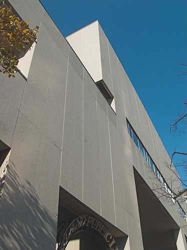
Portlanders have a reputation for architectural conservatism: it's a rare building that goes up downtown without a faux-historical coating of red brick. I suspect that this is one reason that the central library's brash modernist architecture doesn't receive the respect it deserves.


But I love this building. The gravity-defying front entrance (above) creates a quiet, shady courtyard that both expands the public space of Monument Square and provides a calming refuge from the bustle of the city center.


Inside, a skylit ramp leads to the circulation desk and the amply daylighted collections of new books and current magazines. Keep in mind that while this building may have been built before the "green" architecture fad, it was built during a serious energy crisis, and the architecture responds with ample daylight and elements of passive solar design.

I'm especially fond of the side of the building along Elm Street. Metro riders are familiar with this facade and the thoughtful clock that complements the bus schedules posted at the Elm Street transit center. The building mirrors the climbing topography of the street, and a series of one-story "steps" makes the transition from the low-rise neighborhood around Cumberland Avenue to the monumental architecture of Monument Square in the space of one block. From the sidewalk, the long, low main level looks like a delicate counterweight that balances the jumble of higher stories massed near Monument Square:


To be sure, the interior of the Library needs to be updated: how we use libraries has changed dramatically since this building opened in 1979. But the overall structure of the building continues to serve the Library's public education mission remarkably well in spite of its age, and I believe that the generous interactions between the public library and the public square in front of it are a tremendous credit to the building's success.

Now, the old public market building is also nice. But it wasn't designed to be a library: in order to fit in the necessary stacks, desks, and office space, the library's trustees plan to block views of the dramatic post-and-beam ceiling with a second floor in between the ground level and the roof. The renovated market would lose much of its architectural appeal, and at 3/4 the size of the current library, it's going to be cramped to boot.

On a more pragmatic note, the relocation plan would spend millions of dollars in public and private foundation money that would be better spent on things like books, computers, librarians, and educational programs.

The election that will determine this building's fate will be held tomorrow. Vote, please. And if you don't live in Portland, Maine, come and visit our awesome library sometime.

Look at more photos of our library here.

Thursday, June 07, 2007

Love this place.

One of the characteristics that makes Portland such a walkable city is how its greatest public buildings are framed at the end of our streets: look up Temple Street, and there's the stately Unitarian Church. Winding along Fore Street, the streetscape suddenly opens up at Boothby Square to frame the old Custom House. And at the top end of the former Middle Street, we have this, our Public Library, bookending the great public square in the heart of downtown Portland.

Seeing buildings at the end of streets makes our city feel smaller and adds to our street life: if you can see it, you can walk there, and most people do. So all the better if the architectural artwork that our streets frame happens to be a public building like a church or a library. Who wants to stroll down a street that dead-ends at a monstrous concrete parking garage?


This photo comes courtesy of selfnoise, who has many excellent pictures of Portland on his flickr page.
When I was a kid, this building was usually the destination when my family came to visit downtown Portland from Steep Falls, Maine. The building and its surroundings - the Square, the old gothic skyscapers next door - made Portland seem more exciting than it actually was in an era when several Congress Street buildings had been abandoned. When it was built in 1979, downtown Portland was losing its life to the Maine Mall, but the Library gave families like mine a reason to come downtown again. It was, and still is, a great public building that enjoys a mutually beneficial relationship with a great public space, Monument Square.

It saddens me that the Library's trustees are in such a rush to sell this public space short, to abandon a great building to move into a smaller space around the corner, in the shadow of Bayside's white elephant parking garage.

Luckily, it's not a done deal yet. Portland voters will have a chance to save the Library on June 12, during a special election to decide on a bond that would finance the move. We can preserve the library and save a million bucks. Let's all turn out to the polls next Tuesday and vote no on question one.

Wednesday, May 30, 2007

They bulldozed it.


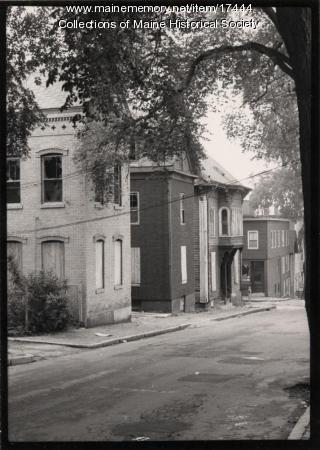
Above: Franklin and Oxford Streets in the 1950s. The other historic photo (below) shows another stretch of the long-lost Franklin Street (historic photographs courtesy of Maine Memory Network)
This photograph here is what the corner of Franklin and Oxford Streets looked like about 50 years ago, before the WASPs on the City Council noticed the Irish name on the corner store, called it a "slum," and bulldozed it all to create the hated Franklin Arterial.

Below, another photograph from the same site of another spot on the former Franklin Street. It's hard to know exactly where, since the buildings, shady elm trees, and even the sidewalks have been gone for decades. For those readers who have never been to Portland, here's what urban renewal gave us instead: a grass median full of garbage, some scrubby trees growing over the old neighborhood's rubble, and four lanes of traffic unencumbered by crosswalks or sidewalks. Here's a photo (the Franklin Towers, Portland's tallest building and a fine example of Soviet Sentimental architecture, commands a fine view of the no-man's-land):


Note how all of these "slum dwellings" in the old photos bear striking resemblance to historic homes that now sell for over $1 million in surrounding neighborhoods. Way to invest in real estate, you jingoist highway-engineering dipshits.

Here's some good news, though: my new buddy Patrick writes about schemes to repair past urban renewal idiocy with a new Franklin Boulevard in the Bollard this week: read about it here. Tomorrow at the Franklin Towers will be a "revisioning workshop" to brainstorm new ideas for the blighted pavement - perhaps I'll see you there. Finally, here's a previous post about fixing Franklin Arterial.

Sunday, May 20, 2007

Sane ideas for the Adams School site

A couple of weekends ago I climbed to the top of the Munj to attend a community charrette for the future of the Adams school and the two blocks of East End neighborhood it occupies.

Billed as a workshop for "crazy ideas," the event was intended to guide the neighborhood association towards a set of goals and guidelines for a forthcoming Request for Proposals for the future development of the site. The ideas turned out to be not so crazy, for the most part - at least, no one proposed a space port or anything like that. More often, people struggled with the tradeoffs of more quotidian desires for a neighborhood with scarce land: Would the neighborhood like to see more housing or more parking? More retail space or more grassy lawns?

We split up into three groups, each of which was guided by some Muskie School planning students and an architect or two to put our ideas on paper. We began by ranking our priorities for the neighborhood: family housing came up most strongly, but so did environmental sustainability and open space.

The conflict between these values struck me early on. Every additional quarter acre dedicated to "open space" means one to three families who won't be able to live in the East End (and they'll likely move to the hinterlands of Scarborough or Standish instead - certainly less than a "sustainable" outcome). Besides, the Eastern Prom, one of Portland's biggest open spaces, is just a short walk away from the school in two directions.

But we also discussed how the East End's plentiful open space is actually used. As it turns out, a lot of it isn't very functional: the majority of it is just a pretty frame for views of the ocean or (in the case of the park on North Street) of the White Mountains. A lot of East Enders use their grassy "open space" primarily as a toilet for their pets, if at all. Even if that is a valid priority, people generally agreed that it shouldn't outrank the need for in-town housing.

But the Adams School's existing playground isn't just a grassy lawn (although the site does have one, and again, it's a dog toilet). It's also an active playground and basketball court that's still well-used even two years after the school's closure. This, it turned out, was what the neighbors in my group really valued: not an empty field faking pastoralism in the middle of the city, but a busy, public square where kids could play and neighbors could meet.

So this is what we came up with:


Triple-decker rowhouses (purple) front Vesper and Munjoy and a new pedestrian court between Beckett and O'Brien Streets. A sun-facing playground and plaza (orange-ish, with green trees) open up along the southern end of the pedestrian connection along Wilson Street, and facing the plaza are storefronts for local non-profits (in blue), topped by additional housing. Two alleys (also orange) through the site access flexible storage space (pink) that can be used as parking or as studio space, at the owner's discretion.

Nan Cumming, who attended as a neighbor but also happens to be the executive director of Portland Trails, advocated early on for connecting O'Brien and Beckett Streets as a pedestrian thoroughfare. Also, our group considered reusing the school, but ultimately rejected the idea in order to make the most of the real estate, recycle the old building's materials, and build new, efficient buildings instead. A sub-group discussed possible ownership models for the housing and concluded that the project should sell affordable, deed-restricted condos built for and marketed to young families.

Then we went to present these ideas to the other groups and hear about their own "crazy" (but not really) ideas. As it turned out, the other groups seemed to hold similar values: housing was definitely the most prominent element of every plan, as was a small playground or garden on the southern end of the site. The other two plans proposed reusing the existing Adams School building for "community" uses or as business incubators, but they also suggested hollowing out the middle portion of the building to provide the same pedestrian connection our group had proposed. No one wanted big parking lots (speaking of which, I wonder if anyone from Ocean Properties is reading this blog yet).

This site plan came from the same group that created the lovely adaptive-reuse drawing above. They've got housing on the north side of the site, along Munjoy, and above commercial uses on Wilson, plus an urban square in the middle and a garden to the south. The school building is would be reused for "community" uses, although I'm not sure how "community" uses would fill all that space and I can't recall the details of their presentation. They proposed adding a sort of pedestrian arcade through the building (see drawing above).

The final group had the prettiest drawings (in my opinion) and the most urban site plan:


They proposed four-story townhouses (top left drawing) along Wilson, Munjoy, and Vesper Streets, and a rehabbed school building with new additions for retail and business incubator space. I thought that their drawing of the reused school was particularly awesome (at right): a sort of warehouse/treehouse perches on top of the old school building with wind turbines.

However, all of the good-looking density that comes with this plan comes at a price: they proposed underground parking, which costs a lot more than surface-level lots or garages. While underground parking looks better, it would probably make the housing here prohibitively expensive for most people.

Now that the conceptual designs are in, the School Reuse Committee will consider the options in its final report to City Council, which will probably put out a Request for Proposals or a Request for Qualifications sometime soon.

Thursday, May 10, 2007

This Is Broken: Tukey's Bridge (of Doom)

Tukey's Bridge crosses Portland's Back Bay between the Munjoy Hill neighborhood and East Deering. It also completes the circuit of Portland's very popular Back Bay running path and links into the Eastern Prom bike path. In short, it is an important and well-used connection in Portland's bike and pedestrian network.

It is also completely and utterly broken: poorly designed and maintained, inconvenient, and unsafe. The fact that so many people still use it nevertheless testifies to its importance as a connector between neighborhoods.

Here's a tour of the bridge from a pedestrian's and cyclist's perspective:

To get to the sidewalk from the south, one must either take the Back Bay path or, if you're coming from any of the neighborhoods on the north side of the bridge, cut through a parking lot and follow a dark, narrow path under an overpass (broken glass abounds, natch).

The bridge makes room for eight lanes of freeway and one meager sidewalk, which is only on one side of the bridge. For most of its length, the sidewalk only has enough room for two people walking abreast. Bicyclists, runners, walkers, and strollers passing each other in both directions are frequently forced to jockey for space: in traffic engineering terms, this sidewalk's level of service gets an "F".

A big part of the problem is the fact that there's no sidewalk for northbound traffic on the other side of the bridge. Cyclists headed north have the choice of breaking one of two laws: either ride (illegally) on the sidewalk that leads into the bridge from Washington Avenue, or stay on the right shoulder of the road, even for the 100 yards over the bridge where it's designated a freeway and bicycles are forbidden (I opt for the latter option, which is faster and safer to my mind).

Anyhow, continuing southward, bikes and pedestrians have a choice between peeling off onto the Back Bay/Eastern Prom trails or continuing on a narrower sidewalk along the off-ramp to Washington Avenue and the Munjoy Hill neighborhood. If you should choose the latter, you'll encounter this off-ramp to Anderson Street:

Note the beefy guardrails. Traffic here is only supposed to be traveling at neighborhood speeds at this point, but this road is obviously designed to encourage much faster traffic. Not that this could be at all related to the speeding pickup truck that hit me, dragged me along the pavement, and ran away just a few blocks down this same street (see previous post).


Because of the guardrails, bikes and pedestrians must cross the off-ramp at the crosswalk, which at least has a bright sign to get the attention of the hurtling traffic.


Once across the off-ramp, bicyclists have two unsavory choices: either continue up the extremely narrow and overgrown sidewalk, as this guy does, until the guardrail ends and you can hop onto the street.

Or, if you want to be legal, wait until the coast is clear...


At the other side of the crosswalk, make a sharp turn against traffic (keeping a sharp lookout to make sure there aren't any cars coming around the bend at 60 MPH)...


Make a tight turn around the end of the guardrail...


...and ride normally up the right side of Washington Avenue (presuming you haven't been vehicularly manslaughtered in the meantime).


The state DOT could easily and cheaply fix the latter hazard by cutting the guardrail at the other end of the crosswalk and installing a curb cut there where bikes can go directly from the sidewalk to the road. This would also make it easier for northbound cyclists to get onto the bridge path from the other side of Washington.

It's kind of a wonder our highway engineers didn't do this in the first place, but I've seen enough highway engineers to know that they aren't fond of using their legs.

I'll be sending this assessment to the following bureaucrats, and I'd encourage you to send your thoughts on this crossing to the same people:

Wednesday, May 02, 2007

Plum Creek III

The third version of Plum Creek's plans for the Moosehead region came out last Friday. It's too soon to know the ending of this saga, but the latest plan leaves things wide open for yet another sequel.

The most visible difference in the new plan, available at www.plumcreekplanmaine.com, is that several housing development areas have been moved from the more remote stretches of Moosehead and Brassua Lakes to areas closer to the towns of Rockwood and Greenville. At the same time, though, the new plan seeks a good deal more land to be rezoned for development, as well as a large increase (500 to 800) in the number of accommodations and condos at a resort proposed near Big Moose Mountain.

Predictably, Plum Creek is crowing that "the revisions would reduce shoreline development on Moosehead Lake and nearby ponds and lakes by 40 percent" (Mike Muzzy, senior manager for Plum Creek), while critics complain that "the plan would double the amount of land on which the project would be developed, from about 10,000 acres to more than 20,000" (Jym St. Pierre of RESTORE: The North Woods). Between these extreme perspectives lies the truth: the new revision doesn't really accomplish much of anything - and it almost certainly won't change anyone's mind about Plum Creek.

A local citizens' group, the Moosehead Futures Committee, has come up with a homegrown set of reasonable recommendations for growth in the area. The group represents diverse interests in the Moosehead region, and has crafted a plan that accommodates substantial new development without raising hackles in the environmental community.

Had Plum Creek adopted their proposal in the first place, their resorts would have been ready to open this summer. Instead, I suspect that the only ones building new houses are Plum Creek's planning consultants, who have secured a long and lucrative tenure through this whole process.

News reports of the new plan:
Plum Creek Revises Moosehead Plan, Bangor Daily News
Critics Not Swayed by New Plum Creek Plan, Portland Press Herald

Friday, April 27, 2007

India is the new Exchange

That's India, the street, not the subcontinent. While the Maine State Pier catches most of the attention, this entire neighborhood is in the midst of a huge transformation that will extend the pedestrian environment and high rents of the Old Port two or three blocks eastward, over the barrier of the Franklin Arterial and up to the base of Munjoy Hill.

Just breaking ground on the corner of Fore and India Streets (look for the rubble of the old Breakaway Tavern) is the Riverwalk development, which has been in the works for a couple of years now. The City sold most of the land for this project to the developers on an agreement that they would build a massive parking garage that will extend along the entire block of Fore Street between India and Hancock.

The development will also incorporate and renovate the Grand Trunk Railway office building on the corner of Commercial and India Streets. The vaguely nauseating pastels in the architectural rendering (left) depict the project from Commercial Street looking west. I'm a little bit creeped out by the trees that have been genetically engineered for semi-transparency, but otherwise, I'm encouraged that the architects and developers seem to be working hard to create a vibrant streetscape on the waterfront, even if there's a huge white-elephant parking garage going up in back.

Just across India Street, a proposed Westin Hotel and luxury condo development that would have replaced the Jordan Meats hot dog factory has lapsed into a dead proposal. Among the factors leading to the project's downfall are rising interest rates and a cooling residential market, some sleazy dealings by one of the developers, and the prospect of a publicly-subsidized hotel a few blocks away on the Maine State Pier.

In spite of these problems, all of the activity going on in the neighborhood makes it very likely that this site will be a big redevelopment site in the next few years. In the meantime, the abandoned hot dog factory remains to entice trespassers, and yet another exciting automobile storage enterprise is bustling in the building's old parking lot.

Finally, just up the hill on Newbury Street, the owners of the Village Cafe are thinking about tearing down their building and surrendering their Wal-Mart-sized parking lot to make way for a complex of 4-6 story condo buildings. Here are two grainy photos of the development proposal I snapped at City Hall a few weeks ago:

The buildings would include ground-floor retail space and a new home for the Village Cafe along Middle Street (at lower left in this picture):


I've witnessed some grumbling about the new luxury condos "gentrifying" this neighborhood, but for the most part, all these buildings are replacing are a bunch of dirt parking lots. It's true that some neighbors will probably see their rents increase as the area becomes a nicer place to live. At the same time, though, a significant increase in housing supply here will help keep home prices affordable across the region, and many of the households moving into a new condos on the Eastern Waterfront will put less-expensive homes for sale elsewhere. And I'm sure that the hundreds of new residents of these tony buildings will be cash cows for Portland's precious local businesses: for instance, all those lap dogs moving in should induce a Pavlovian response from our city's platoon of pet boutiques.

Additionally, even as rents grow more expensive in the neighborhood, an enhanced pedestrian environment and new retail space downtown could reduce transportation costs for all Portlanders as we find ourselves less reliant on our automobiles. This, of course, is another irony of the huge parking garage going up in the middle of the district, but nevertheless, I'm looking forward to this brand-new Old Port.

Monday, April 23, 2007

Can mixed uses preserve the working waterfront?

The idea of putting office buildings and hotels on the Maine State Pier has a lot of problems, but there's also one big merit: new development could raise a lot of money to fix and preserve the pier's deep-water berth, an important piece of waterfront infrastructure.

In the 1980s, a few developers solved the problem of pier maintenance by building condos (on Chandler's Wharf, for example), but the condos effectively evicted marine industries and led the City to enact protective zoning for the working waterfront. New residences are now forbidden on the harbor and non-marine commercial uses are restricted. This solution does a reasonable job of preserving the working waterfront, but Portland's wharves are in bad shape, and some waterfront buildings are tragically underutilized (I'm thinking of a historic 5-story brick warehouse near the Portland Fish Pier in particular: a beautiful building in a great, central location, but its windows are bricked in and the structure is being used for storage).

In effect, the problem is this: we'd like to preserve the working waterfront as a place that's affordable and practical for fishermen and marine industrial businesses to do business, but those businesses are having a hard time paying for the maintenance of Portland's piers and wharves.

Here's a possible solution: allow mixed-use developments on Portland's waterfront, with any kind of space (residential, office, retail, or hotel) allowed above the first floor, on the condition that the ground levels of new buildings are reserved only for marine industrial uses.

By allowing other types of activity on (or rather, above) the piers and wharves of Portland harbor, we can attract more private investment to pay for waterfront infrastructure. At the same time, stipulating that the ground floor of waterfront buildings must be reserved for fishermen and industry will preserve their access to the working waterfront.

Mixed-use development is gaining in popularity, but the idea of industrial mixed-use is still fairly new. One early example could be built in West Oakland, California, where a developer is proposing residential high-rises above manufacturing warehouses (see rendering at left). The proposal would preserve some of the Bay Area's scarce industrial land while providing new housing for a tight residential market.

Ground-floor industrial uses are also allowed under new zoning schemes in Brooklyn's Greenpoint neighborhood and Vancouver, Canada: both are cities where overheated housing prices are crowding out traditional blue-collar industries.

I think it's an intriguing idea for Portland, but I'm curious to know what others think. Could mixed uses preserve the working waterfront and its infrastructure while making better use of haborfront property? Or would it be another nail in the coffin of our fishing and marine industries? I hope that some of you readers will comment and share your thoughts.

Tuesday, April 17, 2007

Fixing Franklin Arterial

I finally made it to the "Lost Sites" exhibit at Aucocisco gallery this weekend. The exhibit seems to have generated a good deal of thoughtful discussion about some of the underutilized places we have in Portland's central city, including an abandoned brick shell of a building on India Street and a locked-up alley that connects Congress Square to a parking lot behind the Schwartz Building.

But most of the submissions dealt with a prominent "lost site" that cuts between the East End and downtown: the Franklin Arterial median strip, a depressed (in more ways than one) strip of grass and trees between four lanes of downtown expressway. Of all the abandoned, marginalized places in downtown Portland, this median strip feels the most out of place and the most forlorn, but also filled with the most possibility.

Franklin Arterial is a product of what they called "urban renewal" in the 1960s. One proposal at Aucocisco includes a panel of what Franklin Street used to look like: a narrow way densely lined with historic buildings (Franklin Street is highlighted in red):


Downtown "revitalization" plans in 1967 and 1968 emphasized bringing more cars into Portland so that the Old Port and Congress Street could compete with suburban strip malls. At the same time, the idea of "slum clearance" was near its peak of popularity: cities nationwide were following the lead of Robert Moses in New York to bulldoze poor neighborhoods and replace their homes with freeways and ghetto high-rises. In hindsight, these concepts weren't so much "urban renewal" as they were "urban eugenics." Nevertheless, these ideas converged along Franklin Street when city planners decided to clear out tenement houses and replace them with a new expressway that connected Portland's waterfront to the planned interstate freeway along Back Cove, now I-295 [Here's a more detailed history of the planning process behind Franklin Arterial].

So, Portland has coped for nearly four decades now with Franklin Arterial, a road designed as an expressway through the center of the city, with no sidewalks, fast traffic, few legal pedestrian crossings and no street life to speak of. It is a moat that divides downtown and the East End, a case study of the failures of urban renewal, a no-man's land surrounded by acres of parking lots and inaccessible "open space."

But here's the good news: there are serious efforts afoot to make Franklin Arterial better. Narrowing the street, adding bike paths and on-street parking, and slowing down the traffic could open up acres of developable land worth tens of millions of dollars (more than enough money to rebuild the street). All three "lost sites" proposals for Franklin Arterial proposed these ideas to some degree, and a joint Munjoy Hill/Bayside Neighborhood Association meeting later this spring (May 31, 6 PM at Franklin Towers) will discuss options for the future of the street.

In the meantime, here are the ideas from the Lost Sites exhibit:


The "Gateway Park" idea makes the open space in Franklin's median strip accessible and more inviting by offering pedestrian access through two underpasses beneath the traffic that would reconnect Oxford Street (one of the streets that had been disconnected by the Arterial's original construction). This would replace the dirt path and the two illegal road crossings that many Munjoy Hill residents currently use to get downtown.


The other two ideas proposed complete realignments of Franklin into a European-style boulevard. These proposals would restore the neighborhood street grids, open up acres of land for redevelopment, and turn Franklin into a more pedestrian-oriented, livable space. As an added bonus, a boulevard realignment would restore the historic Lincoln Park to its original size and proportions (construction of the Arterial sliced of 1/3rd of the park and made it a lot more difficult for East End residents to get to or enjoy the space).


As it stands now, Franklin Arterial blocks new development and diminishes property values in surrounding neighborhoods. Realigning and improving the street might cost tens of millions of dollars, but the new development that would follow would provide new property tax revenue and return the city's investment several times over. Portland's leaders and planners need to get to work and restore this "lost site" into a working asset.