Thursday, March 31, 2016

Public housing for the future

Four years ago I joined the board of commissioners for the Portland Housing Authority with a chip on my shoulder about the fact that it hadn’t built any new apartments for the city since the Reagan administration. So I'm pretty proud about this: we’ve torn out a parking lot on Oxford Street, and in its place we're building 45 new apartments with public housing offices and a Head Start classroom on the ground floor.

This is going to be Maine's greenest building when it's finished. It's aiming for "passive house" certification and we're putting solar panels on the roof. It will have a courtyard that treats runoff under the patio. Most significantly, it’s Portland’s first-ever affordable apartment building that prioritizes housing for car-free households, with no parking on-site, within walking distance of bus routes,  supermarkets, and thousands of jobs. We saved hundreds of thousands of dollars by not building the parking garage that city zoning typically requires, and that's allowed us to build more apartments instead. It’s already won a national competition for innovation in lowering the cost of housing.

Public housing doesn't get the appreciation it deserves. It's facile for liberals to blame it for the tragedies of structural racism in our cities; meanwhile, the right attacks it for its unapologetic Great Society socialism. And as a result we've had decades of bipartisan budget cuts for federal housing programs.

But public housing neighborhoods give millions of people the ability to live amidst the opportunities of our increasingly unaffordable inner cities. Without these neighborhoods, our cities would be even more dramatically segregated and impoverished places.

And if, instead of dismissing it, we can build even more public housing – a lot more, as the Portland Housing Authority hopes to do in the years to come – then the city will be more diverse, more successful and more egalitarian. It will be more like the city we want it to be.

Wednesday, January 06, 2016

Design iterations of the Chrysler building

A scanned page from a 1929 edition of Progressive Architecture shows William Van Alen's iterative development of the iconic Chrysler Building's crown and spire, which was famously constructed in secret in order to outreach a downtown rival. The spire went up to claim the "world's tallest building" title in November 1929, at the dawn of the Great Depression.

I found this, at random, from the New York Public Library's amazing digital collections, which include hundreds of thousands of scanned items. This particular item comes from The Miriam and Ira D. Wallach Division of Art, Prints and Photographs: Art & Architecture Collection, The New York Public Library. (1929-08) [direct link].

Update: thanks to Neil Kelley in the comments, here's a GIF version:

Tuesday, February 24, 2015

The aesthetics of clean energy

My old employer, Maine Audubon, is a fairly conservative and patrician organization. It's not a strong leader on climate issues: its conservation programs are a lot more preoccupied with piping plovers (cute birds that just happen to live on the same beaches as the organization's plutocrat "major donors") than with ending Maine's self-destructive addiction to fossil fuels.

So I was encouraged and a little surprised to see, on a recent visit a few months ago, a large new array of solar panels planted in the meadows of Maine Audubon's headquarters.


Knowing what I know of Maine Audubon's constituency and its neighbors in the blue-blooded suburb of Falmouth,  I presume that this new addition to the meadows of Gilsland Farm didn't come without some controversy. Lots of Maine Audubon's members (and a number of its staff) frankly express opinions that wind farms and solar installations are ugly. They wouldn't disagree that climate change exists, or that we need to do something about it – they'd just prefer that clean energy be built someplace else, where they don't have to look at it.

Maine's community of environmentalists is strongly aligned with the back-to-the-land movement. And in the back-to-the-land narrative, rural Maine was a new frontier where a new, sustainable and allegedly self-sufficient society could be built far away from the problems of the cities.

There's a fatal flaw in this narrative, though. Rural back-to-the-landers were, and still are, cripplingly addicted to oil and private automobiles. As a rule, they don't like to be reminded of this contradiction.

I think that this is the key to what so many rural "environmentalists" find distasteful about wind farms and large-scale solar installations. What upsets them is the reminder, amidst pastoral landscapes, that we are living through a climate catastrophe.

But for those of us who will live with the consequences of that catastrophe, the reminder is overdue – and these small token efforts to avert it are welcome. 


Related: Exporting pollution to Dixie

Monday, July 21, 2014

Silicon Valley's gentrification export

Airbnb, the DIY hotel service that was born in the crucible of the Bay Area's dystopan income divides and astronomical rents, is now spreading its way across the nation. Middle-class households now have the privilege to literally rent out their own beds in order to clear escalating rents in the nation's more fashionable/expensive vacation destinations.

Nick Schroeder, who recently took over the editorship of the Portland Phoenix, has a great feature story about the mixed blessings of the Airbnb phenomenon in this week's issue. He describes how Airbnb can help struggling artists make the rent. But he also points out that unaffordable rents are mainly the product of Portland's (or New York's, or San Francisco's) housing shortages — a problem that Airbnb is only making worse, as landlords convert erstwhile apartments where families used to live into informal, unlicensed hotels for well-heeled vacationers.

Meanwhile, in Next City, a possible solution is brewing in the other Portland, where they're considering an ordinance that would require the licensure and taxation of Airbnb rentals, with tax revenues going towards affordable housing funds.

Such a policy could, in theory, let struggling renters continue to rent out bedrooms when they need to — while also giving the city the means to ensure that there will be fewer struggling renters in the big picture.

Wednesday, May 14, 2014

Art laundry

Postcard, c. 1900, from the Detroit Publishing Company collection. Courtesy of collection Marc Walter / published in An American Odyssey (TASCHEN, 2014). 


Central Park Gates, by Jean Claude and Christo, 2005. Photo courtesy of The City Project.

Tuesday, May 06, 2014

We don't sit in trees any more

In Italo Calvino's The Baron in the Trees, the hero, an adolescent 18th-century nobleman, renounces the earthbound life one evening when his sister serves him a dinner of snails. He spends the rest of his life living in the treetops, from where he falls in love, embraces radical politics, and participates in the political and cultural revolutions of the Age of Enlightenment.

Calvino's novel was written in 1957 — a novel about rebellion in a not-particularly-rebellious era. But a generation later, in April 1970, college students and politicians organized a "nationwide environmental teach-in" held mostly on college campuses. It would later become known as the first "Earth Day."

Historian Jared Farmer recounts one of the first Earth Day protests in his book Trees in Paradise, which I learned about recently on the Huntington Library's blog. A synopsis there recounts how "At Moorpark College, in Ventura County, 50 students laid their bodies down in front of bulldozers to protest the widening of a tree-lined road... By the time 10 students were arraigned in juvenile court on April 22, the first Earth Day, the trees were gone."
“What had been lost? Ancient redwoods? Historic oaks? No. They aren’t even native plants. Most of the trees in question are Australian eucalypts planted in the 19th century as ornamentals.”
With the benefit of 44 years' worth of hindsight, most Golden State environmentalists of 2014 would probably not risk arrest over some Australian eucalyptus trees. Today, they're generally considered an invasive species that sucks away scarce groundwater and fuels dangerous wildfires with their oily foliage and shedding bark.


But trees — especially giant Californian trees — remained a powerful synecdoche for environmentalism. Tree protests reached a peak in the late 1990s when the charismatic Julia Butterfly Hill, with support from Humboldt County Earth First! activists, spent two years sitting in a 600 year-old redwood that she named Luna.

The immediate consequence of Hill's endurance tree-sit was the permanent protection of her tree and a 200 foot buffer zone from a logging operations.

But more generally, Hill's activism attracted national attention to the regional battles between loggers and environmentalists over the fate of the Pacific coast's old-growth forests. Thanks to stronger enforcement of the Endangered Species Act, West Coast logging was already in steep decline by the late 1990s. The activism of treesitting brought the additional accountability of publicity to logging operations.

In the years since Hill climbed down from Luna, living in trees in order to save trees has become rarer and rarer — in part because it has become less necessary. In the interest of avoiding controversy, logging businesses have committed to more sustainable forms of forestry, and conservation organizations have been able to protect most of what remains of the west's old growth trees. More ambiguously, more timber harvesting has moved overseas, away from the critical eyes of Californian idealists.

Today, treesitting feels like a bit of a 1990s anachronism. We're taught, as ecologists, to think about the complexity of global ecosystems. The idea of devoting months' or years' worth of activism to save a small grove of trees can seem like a lark in the context of the world's more pressing, global crises.

But under the apocalyptic threats of losing everything, any form of activism will feel inadequate. Before we throw up our hands, it's worth noting that Julia Butterfly Hill and her tree-sitting colleagues actually accomplished most of their goals, and leveraged influence far beyond their ambitions. It's the Butterfly effect: given enough time, repeated small actions will eventually generate big changes.

Thursday, April 03, 2014

Watch Charles and Ray Eames pitch Eero Saarinen's "Mobile Lounges"

Jess and I took a vacation to the Grand Canyon last week, which was fantastic — but as spectacular as it the thing that actually inspired me to post on this neglected blog was a bleak bit of airport architecture we encountered on our way home.

Our flight got diverted through Washington D.C.'s Dulles airport, and on the way through we were herded into one of these bizarre vehicles (which you might recognize if you've been there yourself) for a ride to the next terminal. They kind of resemble an open-plan double-wide trailer stacked atop a tank chassis:
(image from Wikimedia Commons)


Being in Washington, my initial guess was that these were the unwieldy product of some pork-barrel military industrial contract. But I was mistaken — these weird buggies are actually the vestigial remnants from an unfulfilled future of jet travel.

In 1958, the architect Eero Saarinen was commissioned to design Dulles, which would be one of the first major airports built from scratch to serve jet aircraft. Foreseeing the long walks and sprawling terminals of our modern era, Saarinen suggested that it would be better to employ a kind of satellite parking system for planes, with passengers shuttled from a compact, comfortable terminal onto the tarmac via these mobile boarding platforms, which he called "mobile lounges".

I could go into more detail about the details and rationale behind this idea, but luckily for us Saarinen commissioned this wonderful short film from his friends Charles and Ray Eames as part of his campaign to sell the authorities on his design, so I'll just let them explain it:


Untitled from CHRISTINA LAETZ on Vimeo.

The mobile lounges are like a horizontally-oriented elevator: a door opens, you walk in, you wait a while, another door opens and you exit somewhere else. Airport travel was more glamorous back then, though: on our short ride between the modern Dulles terminals, the mobile lounge was pretty dingy and crowded — certainly nothing like the luxury buses depicted in the Eames' cartoon.

Saarinen's concept enjoyed a brief popularity in the early 1960s — mobile lounges were also adopted at Montreal's Dorval airport and Charles de Gaulle in Paris — but like the Betamax video player, they were an innovation that never quite caught on.

Monday, January 20, 2014

The Grand Canyon of Westbrook

The Grand Canyon of Westbrook is a large volume of negative space out behind the Travelodge (the landmark visible in the photo below, on the Canyon's north rim). I've been past it hundreds of times in my lifetime, but unless you walk out the railroad tracks to stand on the edge, it's easy to miss. The shopping centers and four-lane arterial roads that surround it do a remarkable job of obscuring the city's biggest hole in the ground.


Some online research reveals that the rock of the quarry is gneiss, rock that originally formed as marine clay and slate about 450 million years ago. It was the Ordovician Period, and the mud that would eventually become coastal Maine was accumulating in a shallow subtropical sea surrounding a chain of volcanic islands in the southern hemisphere.
450 million years is a long time. Enough time for seafloor mud to harden into slate, then for that slate to fold onto itself and plunge miles deep into the earth while brand-new Appalachian Mountains rise to the height of Himalayas near the equator, plus enough time for those Himalayan-sized mountains to wear away to White Mountain-sized nubs.
450 million years is nine million times longer than the amount of time it took Blue Rock Industries to make this hole. But now that we're thinking in terms of hundreds of millions of years, in terms of rocks that drifted halfway across the globe and sank four miles under long-gone mountains and resurfaced here, it doesn't seem like such a big hole any longer, in the grand scheme of things, does it?

Just a very temporary divot on a landscape even more temporarily known as "Westbrook," "Maine."

Tuesday, December 10, 2013

Borderlands

I took a walk this weekend out to Westbrook, the city adjoining Portland to our west. Westbrook's Main Street is less than five miles from downtown Portland, but these are small cities and along the borderlands between them there's a still mostly empty landscape of meadows and depopulated infrastructures.

From the edge of Portland I followed the old Cumberland and Oxford Canal, which for a few years in the mid-nineteenth century used to ferry lumber from 20 miles inland to the ocean. It's mostly silted up now, but its towpath is still in use along the edges of the Fore River marshes as a walking trail.


The canal's on the left; the Fore River's on the right. The high-voltage power lines on the right lead eastward towards a substation near the bus terminal, where the power gets stepped down to lower voltages and fed into local delivery lines along city streets. Westward, the same lines lead to higher-voltage lines on the New England bulk power transmission grid. Not far from the junction is the metropolitan area's largest power plant, which burns fracked natural gas delivered from Pennsylvania and Texas via the state's primary north-south gas pipeline.

Under the power lines are the railroad tracks of the old Portland and Ogdensburg line, which put the canal out of business as an overland connection between Portland and Montreal. Over 150 years later the railroad is still less abandoned than the canal is, but only this short section between Portland and Westbrook is at all active. Give it a few more decades and there might not be much difference any longer.

These days virtually all of the cargo between Portland and Quebec is crude oil that goes through in two underground pipelines. Those pipelines also run through these marshes at the head of the Fore River.

And speaking of abandoned infrastructures: on the other side of the marsh I bushwhacked northwards through the woods for a while and found the city's "technology park" (previously written about here). The city finally wrote a seven-figure check to cut down the woods and build a short cul-de-sac here this past summer. And now, just look at all the jobs:


From there I picked up the right-of-way of the oil pipeline back towards the railroad tracks near the Turnpike. Until the Turnpike, the infrastructural routes I'd encountered all trended east-west, from the coast into the mountains. The Turnpike is oriented north to south. Our 19th-century infrastructure treated Portland as a hub of trade to which rural hinterlands could be connected; our 20th-century infrastructure generally treats Portland as the hinterland that needs to be connected to Boston.

There are some decent and uncluttered tags under the Turnpike overpasses here.


A few yards further and I had crossed over into Westbrook, where the silos of a big quarry and asphalt plant loomed over the tracks. It was there that I found the most impressive of all the day's abandoned earthworks — the Grand Canyon of Westbrook. I'll save it for the next post later this week.

Sunday, November 10, 2013

There it is, take it.

Out in Los Angeles they've been celebrating the centenary of the opening of the Los Angeles Aqueduct, the audacious engineering project that drained the Owens Valley and transformed the San Fernando Valley from a landscape of orchards into a landscape of tract homes and gas stations.


It just so happens that this week I've also been plowing through the final chapters of John McPhee's Annals of the Former World, his consolidated narrative of a lifetime's worth of writing on North American geology. So far, my favorite part of that book has been the section on Wyoming, in which McPhee tails USGS geologist John Love on field excursions across the state. The chapters weave the sixty-million-year history of the Rocky Mountains with the hundred-year timescale of Love's family, from his mother's arrival, via stagecoach, in a gunslinging Old West of the early twentieth century to Love's atomic age discovery of uranium in the Rocky Mountain foothills.
"Love said that a part of his job was to find anything from oil to agates, and then, in effect, say 'Fly at it, folks,' to the people of the United States."
The geologic history of Wyoming spans relatively little time in the grand scheme of Earth's history. In the last sixty million years or so, roughly one percent of Earth's lifetime, the Rocky Mountains rose up, then sank under accumulations of sand and volcanic debris tens of thousands of feet deep, then, relatively recently, rose up again and shook off the sand in freshets of new mountain streams.

And then a new geological force arrives. Ranchers arrive in Wyoming, and their sons help open up its landscapes to strip mines and oil wells. The state digs beneath the ranchers'  thin Holocene topsoil to get at the more lucrative geology of the Mesozoic era. Open-pit uranium mines, oil and gas wells, and mountain-eating coal draglines rearrange the Rocky Mountain landscape and usher in the new Anthropocene era.


Photo: Jim Bridger coal mine, from the Casper Star-Tribune.

"Fly at it, folks." Love was talking about the bounty of Wyoming's mineral resources, but it's exactly the same sentiment expressed by William Mulholland, chief of the Los Angeles Bureau of Water Works, when he opened the sluice gates of the new Aqueduct a hundred years ago and famously said, "there it is. Take it."

In the same momentous twentieth century of human history that rearranged Wyoming, Mulholland's power broker friends find cheap oil under Venice and the Baldwin Hills, and then they give the growing city a reason to burn it by moving the Owens River over mountains and irrigating the massive suburbs of the San Fernando Valley. Gravel erosion from the Santa Monica Mountains, which had washed out into the Pacific for millennia and built the vast coastal plain of the Los Angeles basin, suddenly gets trapped behind foothill dams and begins to bury the mountain canyons. The basin itself acquires new sedimentary layers of asphalt and concrete. The sooty remnants of Carboniferous swamps fly into the troposphere through millions of exhaust pipes.

Geologic time and human history converge here, in the spectacular landscapes of the American west. But remember: geologic history is full of cataclysms.

Wednesday, October 16, 2013

Cobweb domes

From Mount Chocorua, New Hampshire. on a day trip back to the subalpine spruce-fir forest near where this blog began:


Thursday, May 30, 2013

The folk art of national identity

Growing up in Maine, the Canadian flag was a common sight — especially in the summertime, when the nearby town of Old Orchard Beach turned into a Québécois Saint-Tropez.

So I was surprised to learn that the Canadian national icon — its maple leaf flag — is a relatively recent invention, and the subject of bitter debate when it was proposed in the Canadian parliament in 1964.

Canada's old flag featured the Union Jack symbol, which was a a snub to French Quebec. In the mid-1960s, when the Québécois separatist movement began to organize, Prime Minister Lester B. Pearson proposed a new national flag that could shore up the nation's unity and give it its own post-colonial identity.

This may not actually have been a productive political gambit. "Quebec does not give a tinkers dam about the new flag," said Liberal politician Pierre Trudeau (Trudeau himself would go on to become a Canadian icon in his own right as one of the nation's most successful and beloved Prime Ministers, mainly for moving the country beyond its British roots and championing a bilingual, multiethnic Canadian identity).

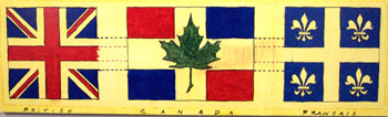
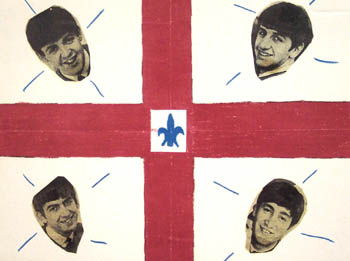
Fortunately, though, the rest of Canada did care about the flag. They mailed in thousands of suggestions in pen-and-ink drawings and watercolor paintings. Beavers, maple leaves, fleurs-de-lis, or the old Union Jack were common themes. Some of the public's suggestions have been digitized on this website from the University of Saskatchewan, and they're pretty amazing examples of Canadian folk art at a time when the adjective "Canadian" was actually beginning to mean something. Each one is a snapshot of a nation that's still trying to figure itself out.

A British-French mashup.


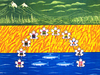
From Manitoba, April 1963:
"The top green strip portrays in the background the Rocky Mountains of the West and the Laurentians of the East....The second strip of yellow gold depicts the growing grain for which Canada is famous...The third strip describes untold numbers of rivers and thousands of lakes...the Atlantic, the Pacific and the Arctic....The coats of arms of the ten provinces which make up Canada are in the shape of an arc and depicts its beginning and origin. Even the shape of the arc has a meaning - freedom, better life and individualism for all those who want to make Canada their new country."


I feel like lots of designs resemble hockey jerseys. From Alberta, 1964:

"Through the Maple Leaf, this flag represents Canada as always being in "the peerpetual light." A light shining over one Canada. People's choice #1."

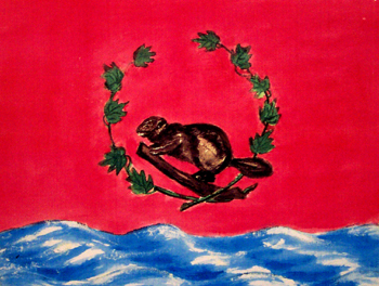
 From Ontario, 22 May 1964:

"If we must have a new flag, it should be one to be proud of, that will bring unity to this wonderful country of ours....The ten maple leaves, for ten provinces. The Canadian Beaver, and waves are for 'from sea to sea.'"

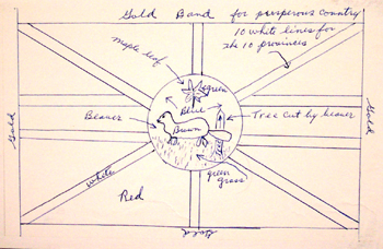
 Quite a few didn't get the memo about how the Union Jack is faux pas in Quebec (submission from New Brunswick, 30 November 1964).
Canada rejected this one, but Idaho picked it out of the garbage and adopted it as its own state flag in 1967.

In the end, Canada avoided old-world heraldry altogether and went with a clean and strikingly modern design. Neither French nor English, the new Canadian flag was one of several mid-century innovations that helped the nation clear out its colonial baggage and define itself on its own terms.


Hat tip to Burrito Justice for finding these and writing about them in his post about funny animals as national symbols.

Wednesday, May 01, 2013

Fossil fuels bike tour

Late last fall, builders wrapped the construction of the new Veterans' Memorial Bridge, which spans the Fore River in the western reaches of Portland harbor. The project included a beautiful new bike path between Portland and South Portland, and this evening I went out to ride it for the first time this spring.


The old bridge (recently dismantled) used to run through the center of the photo above, immediately parallel to the railroad bridge at left. Its former course is now an empty lot with some remnant orange construction fencing. The coastline here is full of concrete riprap and odd tidepools formed from 20th-century construction debris.


Nearby on the Portland side of the bridge is Merrill's marine terminal, which transfers miscellaneous cargoes between ships and the railroad.  There's usually a large pile of coal here, but not much of it remained this afternoon. Maine has no coal-burning power plants, but at least one of its large paper mills still burns coal to fire its boilers.


I dig the interpretive signage.


Calcium carbonate, according to Wikipedia,  is mainly used in construction "as an ingredient of cement or as the starting material for the preparation of builder's lime by burning in a kiln." But these tank cars are more likely headed to one of Maine's paper mills, which are increasingly specializing in value-added coated paper products. Ground calcium carbonate can be used as a filler to substitute for wood fiber, and can also replace kaolin in glossy paper production.

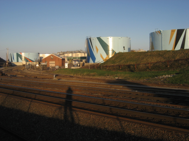
A few years ago, some local philanthropists decided that they needed to beautify the oil tanks with art, and hired a Venezuelan-born artist to design the patterns. I admit I kind of like it, even though I blanch at how much money they spent on it. 


And I'm put off by the a strange impulse to cover the oil tanks in expensive sanctioned art. I'd like to hope that it brings more attention to the oil tanks and makes passing motorists think about their dependence on the global petrochemical industry. But I think most of the wealthy donors are hoping that the paint job will obscure the dirty truth.

On a bike, though, you don't just see the tanks — you smell them, too. A volatile organic bouquet of benzene and sulphates.

A bundle of pipes lead from these tanks to a wharf on the waterfront, where a fuel barge was docked this evening. Similar barges often can be seen refueling tanker ships in the harbor with bunker fuels — the cheapest and filthiest of oil products, so dirty that they generally can only be burned at sea, outside of state and national jurisdictions. A string of oil-containment booms snake out from the wharf's pilings.


For all the fossil fuels on display here, the ability to see them on foot, or on a bike, is a positive development. The new bridge replaces one that had been built in the mid-1950s and designed as a freeway spur. It had one narrow, crumbling sidewalk that dead-ended at a freeway interchange.

Thanks to extensive local activism, the new bridge includes a well-lit bike path, and a lower speed limit and narrower lanes. The freeway interchange on the South Portland side has been  narrowed to a bottleneck where it meets the bridge, in order to force car traffic to yield to bikes and pedestrians.


I like to think how we forced motorists to sacrifice a second or two on their drives across the harbor in order to make the bridge a friendlier place for those of us who prefer not to burn oil. Though I suppose this also means that a few motorists will live longer by not dying in car accidents, only to burn more oil in their old age.

Tuesday, April 30, 2013

The Social Life of Small Urban Spaces

My hometown of Portland is currently considering a proposal to privatize two-thirds of a downtown park called Congress Square — a not-particularly-successful product of late-1970s urban renewal.


There's a broad consensus that the park's current design is a failure. Surrounded on two sides by the blank walls of adjacent buildings, and with odd proportions that make most of the park inaccessible to the activity of surrounding streets, the only people who linger here tend to be panhandlers and loudmouthed street preachers.

The neighboring hotel's new owners, a real estate investment trust called Rockbridge Capital, are extensively renovating the building and would like to have a better neighbor. Even before they came along, there had been some rumblings about renovating Congress Square, and even of selling off a portion of it. But their real and specific offer has accelerated the debate.

It's hard for me — and for many other Portlanders — to hear out a pitch to turn over public space to a 1% outfit that calls itself "Rockbridge Capital." And it's disappointing that it was the hotel's owners — not citizens — that were allowed to set the terms of this debate about what the park's future should be.

Yet in spite of those handicaps, I find myself receptive to their most recent proposal for the park, which, though smaller, would be more far more welcoming and engaged as a public space than the status quo is.

Opponents will still object to losing publicly-owned real estate, but the quality of a park's design is far more important than the quantity of its square footage. The current Congress Square suffers from the same basic design problem as your typical suburban McMansion: it's too big, for no good reason.

In their pitch to the City Council, the hotel's architect included a number of points from William H. Whyte's book "The Social Life of Small Urban Spaces," a brilliant empirical study of what makes successful city parks work.

There's a great film version of "The Social Life of Small Urban Spaces" that illuminate Whyte's theories with detailed footage of New York's Seagram Plaza circa 1980. It's a lot of fun to watch, and not just because it offers a filmed version of the people-watching that attracts us to good parks. Whyte's photography also brilliantly illuminates how subtle elements of design — things most of us don't consciously notice — can have tremendous impact on how public spaces are used. It's like a Roman Mars podcast from 30 years ago.

If you're anything like me (and especially if you're one of my Portland neighbors thinking of weighing in on Congress Square), it's well worth an hour of your time:

Thursday, March 14, 2013

Tampa Bay dérive

I've been spending this week in Tampa, Florida for a new website that my employer is building. Before I'd left I'd asked lots of people for travel advice, but even people who'd been here before didn't have much to recommend. So, on my first day here, when we got out of work early for the day, I took a long walk with no particular destination in mind: what the psychogeographers would call a dérive.

We're staying in a pastel-colored high-rise hotel near the convention center and hockey arena, a neighborhood where all the buildings have apparently been built in the past 20 years.

The district's newness led me to presume that it had been, until recently, some kind of waterfront industrial area, or railroad depot, demolished during the urban renewal fads of the 1960s and 1970s and only just now rebuilding.

But as I walked north into the heart of downtown Tampa, I only found similar neighborhoods and buildings. It seems as though almost all of Tampa had been torn down in the last 30 to 40 years, and replaced with a landscape like this:


As I continued northward into the center of the downtown, the street I was on became barricaded to car traffic, and a lush tropical garden replaced the asphalt. It was here, after four blocks of walking near the end of the workday on a pleasant Tuesday afternoon, that I encountered my first fellow pedestrian.


The street I was on appeared to be the city's attempt to recreate the kinds of "festival marketplaces" that had been faddish in the 1980s, like Baltimore's Inner Harbor or Boston's Quincy Market.


A dated building with steel bay windows faced the pedestrianized street with abandoned kiosks, empty arcades, and faded signs that referred to its address as "city center," as though recalling its glory days.


And then there was this "Municipal Building".


On the other side, nestled in the rear corner of the concrete fortress, I found one of the few old buildings in the city. I detoured half a block to find that this was the old City Hall, still occupied by some of the city's more fortunate bureaucrats.


Changing course to the west, I cut diagonally through a tree-lined downtown square to Tampa Street, where there was a small cluster of non-chain businesses somehow subsisting on the downtown's tiny trickle of foot traffic.

There, I found a used bookstore with an impressive collection of old and rare volumes. I learned, from a circa 1979 Chamber of Commerce coffee table book, that Tampa had been a center of cigar manufacture and a major railroad depot in the nineteenth century. There book also had several photos of an impressive turn-of-the century grand hotel, just across the Hillsborough River from downtown, which was still standing and had been incorporated into the University of Tampa campus.


I struck out west toward the river to see the building for myself and rested a while by the river while a rowing team went by. Turning around, back towards downtown, I was confronted with a less impressive view of two condo high-rises, buttressed with huge parking garages.


The downtown skyline is twice as high as it otherwise would be, thanks to these garages, which squat underneath virtually every high-rise.

Tampans must spend hours driving on their indoor ramps, spiraling up to store their cars on the 7th and 8th stories of their office buildings in the morning, then spiraling down again to drive home, then spiraling up again to park for the night in the high-rise parking decks below their condos.


All over the gulf coast there are houses on stilts, and these are giant versions of the same idea. The streets here are not a place to conduct commerce or meet neighbors, they are a place of transience, a means of evacuation, a place that's ready for sacrifice to the inevitable flood.

The real city begins sixty feet above the ground, behind security gates, with views of the distant bay.


Thursday, February 28, 2013

The Chase Manhattan Bank of Cholera

You probably know that Aaron Burr murdered Alexander Hamilton in a duel. But I recently learned of Burr's surprising and grotesque role in some of New York City's worst plagues — including one we're still suffering through to this day.

My dad recently gave me a fascinating (but not online, unfortunately) medical history of New York City's water supply by Dr. David E. Gerber, from which I learned this:
"In 1799, New York City passed on the responsibility of constructing and maintaining a waterworks to the newly charted Manhattan Company. The company, the brainchild of the improbable team of Alexander Hamilton and Aaron Burr, received from the state legislature a mandate to supply New York City with 'pure and wholesome' water."

Left: Manhattan Company log pipes excavated in 2004 near Coenties Slip. Via New York City Walk (photographer unknown)

But the Manhattan Company was terrible at providing "pure and wholesome water." They employed cheap wooden pipes and instead of procuring fresh Bronx River water, as had been proposed by city officials, they dug wells on the outskirts of the growing city (near today's Greenwich Village) where the water supply quickly became polluted with the city's sewage, or dried up altogether from overuse.

So in spite of a $2 million charter from New York's state government, the growing city continuted to suffer from polluted water. In 1832, the very first year that cholera arrived in New York City (from Asia, via overseas trade), 3,515 New Yorkers died.

There was a reason why the Manhattan Company was so negligently, fatally incompetent at its purpose: it was run by some of the city's earliest investment bankers, including the murderer Aaron Burr.

At Burr's initiative, the Manhattan Company's charter was amended shortly before it took effect to allow the new company to spend its excess capital "in any way not inconsistent with the Constitution and laws of the United States."

The Legislature and Burr's business partner, Alexander Hamilton, seemed to believe that this would allow for additional, future waterworks. But Burr almost immediately exercised this clause to capitalize a new bank, using the money intended for waterworks to give out loans to New York merchants.

The Bowery Boys, the New York history podcasters, have an episode on the Croton Aqueduct that tells some of this same story, and they put it this way:
"There was a banking monopoly where you had the US Federal Bank [i.e., Alexander Hamilton's First Bank of the United States] and the Bank of New York, which was founded by Hamilton, Burr's rival and victim. Burr and his company got a $2 million contract from the state legislature to bring fresh water into New York City.

They decided to spend it thusly: $100,000 on waterworks and bringing fresh water into the city — so 1/20th of the total — and $1.9 million on creating a bank!"

Providing "pure and wholesome water" was just a distracting sideline. In fact, the more the Manhattan Company spent on public waterworks (there were no water meters back then, thus no reliable user-fee system, thus no profit motive), the less they had to spend on high-interest loans to New York City's merchant class.

Hamilton evidently didn't like the competition from a new bank in town: he left the Manhattan Company shortly after Burr capitalized his new bank with 1.9 million New York State taxpayer dollars.

The citizens of New York suffered the Manhattan Company's filthy water until 1842,  when the City of New York finally opened an aqueduct from the Croton River, which provided public drinking water that was genuinely pure and wholesome, and does so to this day.

So New York eventually addressed its sanitation problems and cured its epidemics of cholera and yellow fever.

Unfortunately, Aaron Burr was only an early vector in New York City's raging plague of assholes who collect millions of dollars from the government in order to enrich themselves in the global banking casino.

In 1955, Aaron Burr's Bank of the Manhattan Company merged with the Chase National Bank to become Chase Manhattan. And in 2000, Chase Manhattan bought out the investment firm JP Morgan to become JP Morgan Chase, on whose website you can today download a short history that tells part of this very same story. This document includes some pictures of old wooden pipes and a quaintly threatening engraving (below) of their company's founding chief executive ballistically perforating the Founding Father on our $10 bill.

However, somehow JP Morgan Chase's PR department neglected to mention the part about all the cholera — hopefully they'll appreciate this addendum.


Monday, December 03, 2012

Making the Geologic Now

I'm taking off on the bus for New York early tomorrow morning to visit some friends and stop by the launch party for Making the Geologic Now, the new book edited by Jaime Kruse and Elizabeth Elsworth of the Friends of the Pleistocene and smudge studio


The book includes an essay on the Bayside Glacier contributed by yours truly. I'm really proud to be part of this project, among many writers and bloggers whom I've long admired. I've had a chance to see parts of it already, and it looks fantastic.

After tomorrow's launch party, you'll be able to download a free e-book at Punctum Books’ website, or browse an interactive web version at www.geologicnow.com. Pre-orders of the print version, which should ship in December, will also be available soon through Punctum’s website.

Image: the Sable Oaks glacier, a municipal snow dump located in the flight path of the Portland International Jetport.

Tuesday, November 27, 2012

Cities & Memory


From Italo Calvino's Invisible Cities:


In Maurilia, the traveler is invited to visit the city and, at the same time, to examine some old post cards that show it as it used to be: the same identical square with a hen in the place of the bus station, a bandstand in the place of the overpass, two young ladies with white parasols in the place of the munitions factory.


Photo courtesy of the Friends of the Eastern Promenade


If the traveler does not wish to disappoint the inhabitants, he must praise the postcard city and prefer it to the present one, though he must be careful to contain his regret at the changes within definite limits: admitting that the magnificence and prosperity of the metropolis Maurilia, when compared to the old, provincial Maurilia, cannot compensate for a certain lost grace,


Photo by Corey Templeton

which, however, can be appreciated only now in the old post cards, whereas before, when that provincial Maurilia was before one's eyes, one saw absolutely nothing graceful and would see it even less today, if Maurilia had remained unchanged; and in any case the metropolis has the added attraction that, through what it has become, one can look back with nostalgia at what it was.


Beware of saying to them that sometimes different cities follow one another on the same site and under the same name, born and dying without knowing one another, without communication among themselves. At times even the names of the inhabitants remain the same, and their voices' accent, and also the features of the faces; but the gods who live beneath names and above places have gone off without a word and outsiders have settled in their place.


It is pointless to ask whether the new ones are better or worse than the old, since there is no connection between them, just as the old post cards do not depict Maurilia as it was, but a different city which, by chance, was called Maurilia, like this one.


Photo credits:
Historic postcards from MaineMemory.net.

Present-day photos courtesy of (from top to bottom): Friends of the Eastern Promenade, Corey Templeton via the archboston.org forums, Corey Templeton via the Portland Maine Daily Photo blog, and Panaramio user sacoo.