Tuesday, August 03, 2010

Pelicans Meet the Markets

The Planet Money podcast - which continues to be excellent, even now that we're (maybe?) out of the economic apocalypse and there's no longer a pressing need to explain what a credit default swap is - takes a crack at tallying the price tag for dead pelicans in the Gulf:


This is a practical problem right now as we figure out how much we should fine BP for its spectacular oil spill. What's a fair price to put on the damage? In some cases, that's pretty easy to figure out: we can multiply the x tourists who won't be visiting oily beaches this summer by the y dollars they might have spent at seaside hotels and beach towns, and then we can add in the loss of p tons of commercial seafood, which would normally sell for q dollars per pound.

But how do you calculate the value of rescuing an oily pelican? Unlike shrimp and hotel rooms, there's no market for most of the Gulf's wildlife.

One strategy is to ask people how much they'd be willing to pay to save one pelican. Animal rescue groups, for instance, are spending about $500 on each bird they save. That tells us that each pelican is worth at least $500 among bird enthusiasts, who may well be willing to pay even more than that. But presumably most people aren't ready to cough up that much money to save one bird.
BP Oiled Birds in Louisiana

Broadening this approach gets into the economic method of contingent valuation, which was first employed on a large scale to figure out the damages caused from the Exxon Valdez spill in 1989. In this method, economists deliver surveys to a broad swath of the population - including people who will never see a pelican in the flesh - to ask them if they would be willing to pay $X dollars to save one bird. As with any product, values will differ: some people will say "no" to paying $2, while others will say "yes" to paying $100. But with enough responses, economists can construct a demand curve, and figure out the equilibrium where the marginal cost of saving one more bird is just equal to society's marginal benefit.

So, if there are 20,000 people in the world who say they're willing to pay at least $500 to save one pelican, and it costs $500 to save each pelican, then BP should pony up $10 million to save 20,000 pelicans.

This method, too, is controversial. Its biggest problem is that it's too abstract - it's easy to tell a survey-taker that you'd pay $500 to save a pelican, but if the opportunity actually presented itself, would you really postpone your credit card payments to save one bird?

Even for environmentalists, it's a problematic question. Most would probably argue that we, as a society, should spend $10 million to save birds, right? But what if that means that we, as a society, will no longer be able to afford to spend $10 million on a solar energy project, or to conserve a wilderness area from development? Is the immediate plight of few thousand pelicans in the Gulf more important than shutting down a coal plant, or preserving a wild forest?

When I studied environmental economics in college and administered contingent valuation surveys about Oregonians' values of wild salmon in a seminar with Dr. Noelwah Netusil, there were a number of campus activists in my classes who bristled at any notion of putting an economic value on wildlife. Preserving the environment was a moral imperative, in their view, and it needed to be done without regard to the cost. They also criticized its anthropocentrism: how dare we impose our human values, and the structures of a social science, on a natural system that had been around for billions of years before Adam Smith?

That's a nice sentiment, and it may even be an honest reflection of their personal values - they may well have been willing to sacrifice everything they owned for wild salmon.

But it's not realistic for society as a whole. Economics is about managing scarcity, and dedicating our limited resources to achieving the best outcomes. Homo sapiens isn't the only species that practices economic calculations. A wolf makes hunting decisions based on whether the expected value of a meal is worth the cost of running to catch it; plants allocate energy and resources to roots or leaves depending on the respective values of nourishment from the soil or from the sun.

In the 21st century, environmentalists have no shortage of demands on their time and money, and our time and money are scarce resources. The view that everything in nature is sacred and has infinite value is not productive. It's preventing individuals and organizations from setting priorities and winning victories.

At some point, we'll need to stop worrying about the pelicans and start paying those workers to build solar panels and public transit lines, instead of using toothbrushes to get oil out of feathers.

Wednesday, July 21, 2010

Dumpster Pools on Streets Without Cars

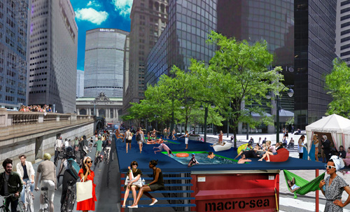
Damn, that last post was a real downer. Sorry, everyone. Why don't we beat the heat by taking a dip in a recycled dumpster parked on a car-free Park Avenue in front of Grand Central Station?


This is roughly what Park Avenue near 42nd Street will look like on three consecutive Saturdays in August, when the city invites pedestrian and cyclists to enjoy major streets without any motor vehicle traffic. It has all the trappings of a futuristic Ecotopia, where fashionable pedestrians have re-conquered the highways from automobiles and dumpsters hold swimming pools instead of garbage. Luckily the image above is just a Photoshop job, so that kid diving into the shallow end isn't really going to break his neck.

The dumpster pools are a new addition for the second annual "Summer Streets" event. This massive prohibition of motor vehicle traffic on one of Manhattan's major avenues to is actually an initiative of the city's Department of Transportation under the leadership of Janette Sadik-Kahn, an avid cyclist and pedestrian. Let this be a lesson to all the other Departments of Transportation: while your pencil-necked bureaucrats are making life more difficult for pedestrians and designing expensive new ways for people to waste their time in traffic, New York City is showing us how transportation planners can actually be lovable.

Monday, July 19, 2010

It's been warm where I am, and where you are, too


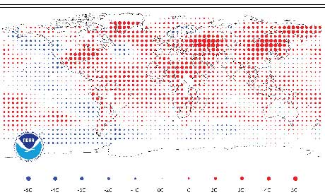
This Guardian summary of the latest record-breaking temperature data from NOAA is chockablock full of staggering and depressing facts. Among them:
  • Last month was the hottest June ever recorded worldwide and the fourth consecutive month that the combined global land and sea temperature records have been broken.

  • According to NOAA, June was the 304th consecutive month with a combined global land and surface temperature above the 20th-century average. The last month with below-average temperatures was February 1985.

  • Separate satellite data from the US National Snow and Ice Data Centre in Colorado shows that the extent of sea ice in the Arctic was at its lowest for any June since satellite records started in 1979.

I found this report via Wired writer Bruce Sterling's Twitter feed, where he made the powerful observation that we'll spend the rest of our lives "dolefully watching physical realities like 'hottest month ever recorded.'"

Future heat waves will break records of the less-distant future, which themselves will outdo these heat extremes of the present day. Struggling journalism institutions like the Guardian will cut costs by recycling the same report, tweaking the details as necessary, and someday soon getting rid of the reference to Arctic sea ice when Arctic sea ice disappears altogether.

But at some point, the reports will cease. When agriculture fails and as more and more nations collapse over water shortages and economic turmoil, organizations like NOAA will either lose their capacity to collect and analyze global climate data, or cease to exist altogether. At that point in our lives, if our lives haven't gone the way of our political and economic institutions, we'll no longer be burdened by these reports and their staggering statistics.

We'll merely be burdened by the staggering reality of a broken world.

Tuesday, July 13, 2010

Organic labels


Via Wonder-Tonic.com, "a downloadable set of 16 stickers to let you label your favorite foods, books, and appliances as organic. Just print them out, stick them on, and start feeling good about yourself!"


Wednesday, July 07, 2010

Hot Days Incinerate Oil

If you're an electric utility, you don't take the dog days of summer lying down. No, when it's 95 degrees outside, that's when you want to burn millions of gallons of oil in your oldest, least efficient power plants. Beat the heat by starting a thousand-degree inferno.

That's exactly what's happening across the northeastern United States this week, as record temperatures are also breaking records for electrical consumption. It's the first law of thermodynamics writ large: as millions of office buildings, supermarkets, and houses work their AC units to stay cool, the region's utilities need to put massive amounts of heat into the system, and they fire up every power plant they have at their disposal to meet the demand.
Most utilities keep a handful big power plants in reserve, maintained year-round just to operate a handful of times a year when the grid needs to call in the cavalry. Many of these plants tend to be old and relatively inefficient: they're not economical to run on a daily basis, but they're maintained in running condition for the handful of days each year when they might come in handy, and when spot-prices for electricity rise high enough to justify their high costs of operation.

One such power plant is located right on the edge of scenic Casco Bay, visible from Portland's Eastern Promenade Park and from thousands of other waterfront vistas in greater Portland. Wyman Station, about which I've blogged previously here, is a 1970s-vintage oil-fired power plant capable of generating more electricity (over 800 megawatts) than any other plant in Maine. It's old, it's inefficient, it burns expensive fuel, and it occupies extremely valuable coastal Maine real estate. But it's still there for those few times when a million air conditioners ask the grid to turn the juice up to eleven, and pay for the privilege.

In 2005, the most recent year for which data is available, Wyman Station, in spite of its sporadic use, still managed to produce 2860 tons of sulphur dioxide, 155 tons of carbon monoxide, and 736 tons of nitrogen oxides (source: US EPA). According to the US Energy Information Administration, burning a thousand gallons of heavy oil in a typical boiler yields about 47 pounds of nitrogen oxides, so a little math tells us that Wyman burned somewhere on the order of 30 million gallons of oil in 2005.

In SI units, that is 1.3 shit-tons of filthy fuel. Imagine the Deepwater Horizon oil leak spilling into Casco Bay for 7 days, and you'll have a rough idea of how much oil Wyman burns every year. Go ahead, imagine it.

As I said before, this is for a plant that's only run for a few days each year. So here's the good news: every New Englander who turns off the lights in their office, or shuts down their computers during the hottest mid-afternoon hours to do some old-fashioned analog work, can help save a few gallons of oil from going up in smoke. Many utilities are giving large customers a price break if they do this on the hottest days, since asking your customers to turn off the lights can be cheaper than running expensive diesel backup generators. Right now, this is all done with polite phone calls, but in the near future, appliances will develop a hive mind to communicate with the electric grid, take turns sucking down scarce juice, and keep places from Wyman Station from starting fires on hot days. Others have argued that the situation calls for more solar panels, which tend to generate the most electricity on these hot and sunny summer days.

In the meantime, consider giving your appliances - and your local power plant - a break on these hot afternoons. With or without futuristic "smart grid" technology, if a few thousand New Englanders manage to cut back their consumption on hot days, we could shut places like Wyman Station down for good.

Friday, July 02, 2010

In Seach of Moosey Paradise: A Walk Along Portland's Inner-City Wildlife Corridors


The big news here in Portland yesterday was a young bull moose who had wandered into Deering Oaks Park, a formally-landscaped open space in the central city. Just like the opening credits of Northern Exposure, but with more spectators.

According to reports, the animal took a dip in the park's pond, where it attracted a small crowd of onlookers, as well as the city's police department and a state game warden, who were concerned about how it would cross I-295 on its way out of the city. One of my favorite details of the story is how they were going to shoot the animal with a tranquilizer, but the warden's gun jammed just when she got a clear shot. Apparently Portland's big-game armory has suffered from infrequent use.

It ended up taking the Forest Avenue underpass, crossing one of the city's busiest streets twice, then escaping through the University of Southern Maine campus. It was later spotted at Chevrus High School, located in an inner suburban neighborhood, before it made its way west through the woods in Evergreen Cemetery. The animal was reportedly exhausted, but unscathed.

This isn't the first time a young bull moose has appeared in downtown Portland. A few years ago, police shot one in the middle of the city's Munjoy Hill neighborhood - an even stranger place to see such a huge animal, since it lies at the end of a peninsula, cut off from the mainland by a freeway and the city's central business district. That was also early in the summer, a time of year when juvenile males tend to strike out on their own and take risks in pursuit of their own territory.

These moose that wander into the city obviously have no conception of where it was, just a sense of hope that, on the other side of this neighborhood, it might find a big-enough block of swampy woods with a small surplus of female moose. I'm reminded of how deer and other mammals came to populate islands far from and out of sight of the mainland, swimming for hours on a vague scent, with no way of knowing how much further land would be, or whether they might drown in the crossing. At the risk of anthropomorphizing, I'm impressed at this moose's sense of adventure - its willingness to take big risks to find a great new place.

This kind of exploration is hard to come by for anyone who actually lives in and knows the city. But the moose's path in and out of Portland seems to have gravitated towards the city's remaining blocks of undeveloped land and forested parks - and the places where a moose would feel most at home happen to be the kinds of places I most enjoy exploring myself.

Because there aren't any public reports of the moose before it was sighted in Deering Oaks Park, it's hard to tell how this particular moose got into the city, but I suspect that it either came in the way it left, through Evergreen Cemetery, or it ventured in along the banks of the Stroudwater and Fore Rivers. Here's a map:


Although Portland is on a peninsula, there are two large blocks of wildlands on its fringes that extend towards the central city. To the south, critters like deer and coyotes regularly migrate into the city along the Stroudwater River, which is surrounded by a large block of swampy, undeveloped woods, as well as several farms and golf courses. The Maine Turnpike, probably the biggest barrier for critters trying to get into the city (it's the red-dashed line running across the map above) flies over the Stroudwater on a wide bridge, which makes it easy for critters (and people - this is roughly the path of the Stroudwater Trail) to cross under the highway:


On the other side of the Turnpike, just north of the mouth of the Stroudwater, there's the Fore River Preserve, a former Maine Audubon property that occupies the headwaters of the Fore River along with acres of marsh and forested uplands. From the Preserve, a moose bound for the city could walk through the sparsely-populated neighborhood between the Fore River and the railroad tracks, cross under I-295 at the bridge, and then follow an abandoned railway into Deering Oaks, without seeing a human soul.

Alternatively, a critter could cross the Turnpike at one of two other Turnpike underpasses: one at Warren Avenue, a relatively rural-feeling road that cuts through an industrial area, and one where the Presumpscot River passes under the Turnpike in the city's northernmost reaches. From either of these options, a moose could cut through the thin patches of woods between houses in the city's low-density outer suburbs, before reaching the the Evergreen Cemetery. While the front of the Cemetery, along Stevens Avenue, is highly landscaped, and doesn't offer much cover for critters, the back of the Cemetery is a huge, wild forest that extends almost all the way to the Turnpike. Better still, right across Stevens Avenue from the Cemetery is Baxter Woods, a forested city park, which itself is just a skip across a busy road and railroad tracks to a smaller tract of woods around the new Ocean Avenue School. From there, its just a matter of trespassing through some inner-suburb backyards to get to the parklike University of Southern Maine campus, which is right across the freeway from Deering Oaks Park. The moose yesterday opted to take a detour to the north to visit Chevrus High School, but this roughly describes his escape route.

By coming into Portland, this moose has demonstrated to us an inner-city bushwhacking course through the wildest remaining areas of our city. While I've hiked portions of this itinerary before (such as the Stroudwater Trail, which I described here), I've never tried to do the whole thing in a day, as this moose did. But I think it would be fun to try.

Tuesday, June 08, 2010

The Geotaggers' Atlas


On the photo sharing websites Flickr and Picasa, users can "geotag" their photographs with specific longitude/latitude coordinates on a map, as a way of organizing their own collections and seeing other photographers' images of the same neighborhoods.

Geographer Eric Fisher has mined this data using the sites' public APIs to create the "Geotaggers' World Atlas," a collection of maps of 100 major global cities, overlaid with points representing where users have posted their photographs. The resulting images are fascinating, information-rich portraits of the places where photographers (or, more precisely, web-savvy photographers who upload their photos and tag them with geographical data) congregate.

Thus, the map of London shows dense concentrations of photos in the central business district, but also in Greenwich and Canary Wharf (the two blobs near the east side of the map), in Kew Gardens (on the west side), and along the city's principal streets. The banks of the Thames River are clearly delineated as well, and criss-crossed by dense clusters of photographs taken on the city's bridges:


Other maps reveal more about where digital photographers who use Flickr and Picasa are likely to live and hang out. Here's Portland, Oregon, a city I'm familiar with from my college days at Reed College:

As in London, the banks of the Willamette River are clearly delineated in the downtown area, where there's a popular park on the western bank and a bike path on the eastern bank, as are the city's bridges. The horizontal line just south of downtown is the city's new aerial tramway, a photogenic segment of the transit network that connects the riverfront to the Oregon Health Sciences University complex high above in the city's West Hills.

A small knot of photos on the east side of the map represents Mount Tabor Park. Between there and downtown stretches Hawthorne Boulevard, a business-lined Main Street that runs all the way to the Hawthorne Bridge into downtown. You can also make out North Mississippi Ave., plus Killingsworth and Alberta Streets, north of downtown. These neighborhood Main Streets aren't particularly dense areas of the city, nor are they tourist magnets. But they are the business and entertainment districts for gentrifying neighborhoods where Flickr's young, web-savvy users like to hang out and take digital pictures of their friends.

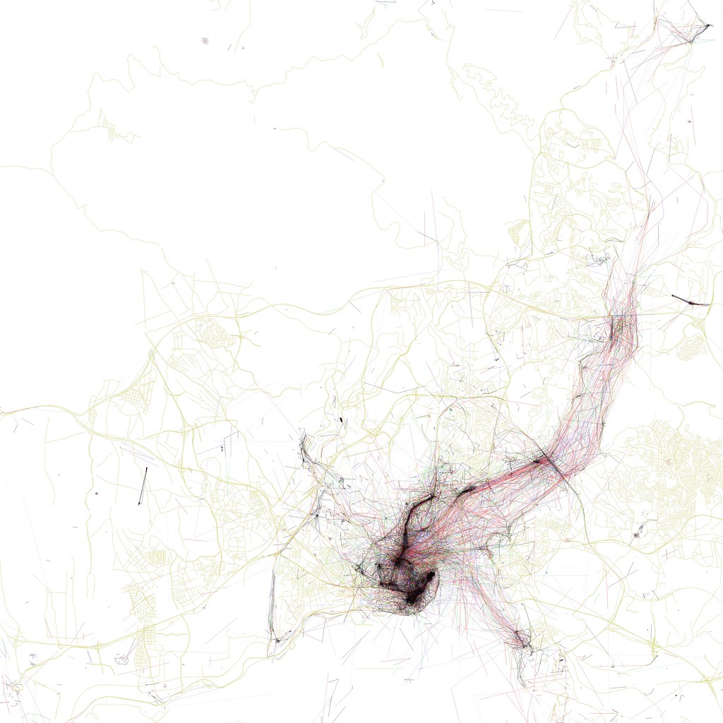
These maps can also say a lot about a city's distinctive way of life. Here's Istanbul:

The dense quadrangle in the bottom-center of the photo represents the city's major tourist sites: clockwise from the western corner, they are the Grand Bazaar, the waterfront near the Spice Bazaar, the palace complex, Hagia Sofia, and the Blue Mosque. Extending north from the Spice Bazaar is a dense cluster of photos across the Galata Bridge, up the hill past the Galata Tower, and along the arc of İstiklal Cadessi, a major nightlife and shopping district.

But unlike other cities, Istanbul's map is defined less by streets, and more by the broad waterways that separate its neighborhoods. From the Golden Horn (the central peninsula at the bottom-center of the map) emanates a web of photographs and multiple-exposure photo paths taken from ferries and other boats traveling along and across the Bosporus straits. Clusters along the shore represent ferry terminals at Beşıktaş, Harem, and other neighborhoods. Istanbulites clearly spend lots of time on boats, and like to pass the idle time on the water by snapping photographs.

More recently, Fisher has updated a number of these maps to differentiate photos from tourists and photos from locals (his methodology: if a photo comes from someone who is still geotagging photographs in the same city within 30 days, it qualifies as a "local"). These "Locals and Tourists" maps add another layer of information to distinguish the places where tourists go from the places that locals find to be the most interesting.

Here's New York. Red dots represent "tourist" photographs; blue dots are from locals, yellow dots could be either:

Ellis Island and the Statue of Liberty stand out as bright red clusters in the lower left corner, connected to the red Battery at the southern tip of Manhattan by a dense web of photos from ferry rides. Just to the right is the blue, teardrop-shaped outline of Governor's Island, a newly-opened park that seems not to have caught on yet with visitors, which is itself just above a blue cluster around Red Hook, another neat neighborhood that is definitely far from the tourists' beaten track.

There's a lot of red in midtown Manhattan, especially along 34th Street (the Empire State Building), 42nd Street (with Times Square, Grand Central, and the UN on the East River), around Rockefeller Center, and in the southern reaches of Central Park. Locals predominate along the avenues of the upper west side, in Riverside Park along the Hudson River, in the Lower East Side, and in the Brooklyn neighborhoods of Park Slope, Fort Greene, and Williamsburg, as well as in the old World Fair grounds in eastern Queens. And note the small cluster of red and blue dots around Yankee Stadium in the Bronx (in the upper center of the map) and around the Meadowlands sports arenas over in New Jersey (on the left edge of the map).

And here's San Francisco. Can you spot Alcatraz?

San Francisco is the center of the metro area where both Flickr and Picasa have their headquarters - apparently a lot of their employees and enthusiasts live in the Castro and Mission districts (the dense blue grids just south of downtown).

What I really like about the Locals and Tourists maps is the possibility of using them as a tourist's guide to un-touristy places. If I were going to Washington, for instance, I might want to cut short the sightseeing on the Mall to check out those blue clusters north of Dupont Circle around Meridian Hill Park, or see what the locals find so photogenic about the Potomac River in Georgetown. The Space Needle is clearly popular among visitors to Seattle, but maybe my time there would be better spent finding out why the locals take so many pictures around East Union and North 45th Streets.

Using the maps this way might be particularly useful in Paris, where there's evidently no shortage of photos of the Eiffel Tower. Parisians seem like the kind of people who'd be a lot more friendly and welcoming to visitors who don't contribute to the mobs around the Louvre and Île de la Cité and are brave enough to venture to the more genuine parts of the city. The 19th and 13th arrondissements look promising.

That said, I've also never been to Alcatraz myself, and I'd like to go. Most tourist destinations attract visitors for good reasons - but these maps demonstrate that there are plenty of off-the-beaten-track neighborhoods that are worth visiting as well.

Maybe Fisher will share his secret coding techniques with the rest of us so we can produce maps of our own - I'd be especially curious to see Locals/Tourist maps of the east-coast Portland, and of Houston.

It would also be interesting to slice this data in other ways, in addition to Fisher's clever tourist/locals divisions. For instance, what if we separated out the photos that were taken on weekends from photos that were taken on weekdays? Or map only photos taken between 9 pm and 3 am, to generate a diagram of cities' best nightlife neighborhoods? You could even go so far as to analyze the light and color balances of these photographs and generate maps of places where people go on gray rainy days, versus places where people go to photograph blue skies, versus favorite destinations on white snowy days.

In the meantime, both the Geotaggers' World Atlas and the newer Locals and Tourists maps are very much worth browsing, although, like me, you may lose hours to scrutinizing the richness of their information.


Tuesday, June 01, 2010

A Park Gained, A Wilderness Lost

When I was in New York a few weeks ago, I finally made a visit to the High Line, the city's new park on an abandoned elevated rail line on the west side of Manhattan.

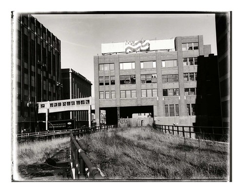
The High Line, in 2007 and in 2010 on TwitpicLeft: the High Line in 2007 and in 2010: cultivating native plants and overpriced condo towers. Click to enlarge.

I had been pretty excited about this park for a long time - I first learned about it in 2006, the year I was working for the City as an Urban Park Ranger, when the project first broke ground. For me, the High Line was a vindication of my idea that a city's hidden pockets of wildness - often on the forgotten margins, like the abandoned industrial neighborhood around the High Line - could be celebrated for their unique ecosystems and natural resources, instead of being condemned as "blight."

Since it's opened to the public, there can't be any doubt that this abandoned railroad has been a cause for celebration from residents and tourists alike.

But when I visited last month, I had to wonder if something was lost in the High Line's transition from abandoned railroad to public park. The High Line is stunningly designed, packed with native plantings, and it's opened up new ways for New Yorkers and visitors to experience the city.

But is it wild anymore?


The High Line in 2001, by Jonathan Flaum:And in 2009, via Inhabitat:


The overwhelming impression I got from walking on the High Line this spring was of wealth. The park was clearly expensive to build, with tropical-wood furniture, elaborate fountains (they were under repair while I was there), and meticulously tended foliage. The carefully selected varieties of native plants were evenly, geometrically spaced in mulched planting beds outfitted with an irrigation system. A forest of new condo high rises and hotels, designed by global celebrity architects, loomed over the rehabbed warehouse buildings of the former industrial district.

Great architecture is all well and good. But I found that the High Line, in its "finished" state, was less like the wilderness I'd hoped for, and more like a formal garden for the gentry of Chelsea: a sort of post-industrial Versailles.

I feel like this is a missed opportunity. After all, ostentatious displays of wealth in New York City are not all that compelling or interesting - they're pretty much a dime a dozen.

The High Line, before it was a park, had been a refuge from a landscape obsessed with capitalizing and selling every square foot of space. Here there were acres of land that existed outside of the consciousness of real estate, where weeds, small mammals, birds, and the occasional human adventurer were free to wander in a two-mile meadow, simultaneously above and surrounded by the city. That's where it derived its wildness.

As a landscaped park, though, the High Line is obviously a real estate amenity. When every prospect offers views of shiny condo towers and expensive lofts in expensively rehabbed warehouses, and designer signage implores you to stay on the designer concrete pathway, it's obvious to the visitor that this park was financed and built by developers and neighbors angling to increase their own property values. In the process of becoming a public park, the High Line became co-opted by New York City's real estate juggernaut.

In the process, an essential part of the High Line's promise - its freedom, and isolation from the commodification and control of New York City's landscape - has been lost.*

The new High Line park's design also botches the structure's historical context. Until 1980, the High Line railroad had been used to deliver agricultural raw materials to various food processing plants in the neighborhood. Refrigerated boxcars full of cows, for instance, were delivered to the slaughterhouses of the Meatpacking District. Several spurs curve from the main line into adjacent buildings, and in some places, the High Line actually travels through the middle of buildings, with old loading docks on either side.

Here's a photo from the mid-twentieth century of the High Line where it runs through the National Biscuit Company (a.k.a Nabisco) complex. These are the same buildings pictured at the top of this post:


For decades, then, the High Line (and its surrounding neighborhood) played an important role in feeding New Yorkers, and commodifying the agricultural bounty of the Midwest into value-added processed foods. There's a rich historical narrative here about the industrialization of agriculture, the centralization of food processing, the rise of supermarkets... but there's no trace of any of this in today's High Line Park.

This was the other big thing that unnerved me about walking along the High Line. The structure's wrought-iron railings, steel I-beams, and the handful of high-ceilinged brick warehouses surrounding the old railway clearly hearken back to a lost industrial past. But everything about the park itself, and the expensive architecture that surrounds it, drives home the fact that that industrial past is entirely gone. This used to be a neighborhood that made things and trafficked in the heavy, bulky products that required massive railroads to move. The High Line itself used to be a vital connection between the City and the natural resources that fed it.

But today, the neighborhood traffics in abstractions: there's tremendous wealth here, but it's anyone's guess where it comes from.

Back in 2007 I wrote about how the abandoned High Line illustrated the ecological succession of urban vacant lots
:
Over the years, more dust, leaves, and soot blew in. Each fall, the topsoil gained another layer of dead grass and leaves from pioneer weeds like goldenrod, Queen Anne's lace, and Ailanthus Altissima... the new High Line park will have benches, new concrete paths, easy access from the street level, and drought-tolerant landscaping that mimics the wild weeds that inspired the park.

It might seem like an interruption and commodification of the wild successional process, but New York is nothing if not habitat for homo sapiens, and the new High Line fits in perfectly with New York's typical neighborhood succession: places once run-down and diverse inexorably become unaffordable and boring. At least until the next large disturbance, anyhow.
When the new park opened in 2009, we were in the middle of a huge financial crisis that seemed to hold out the promise of being that "next large disturbance." Here's an excerpt of the post I wrote at the park's grand opening:
In the new economy, the High Line feels a lot weirder. It was meant to be a futuristic preserve for New York's past - especially its overgrown lots and abandoned industrial infrastructure. Now that the park is open, though, the ultra-slick High Line feels a bit out of place. Instead of evoking New York City's past, the High Line looks more like an expensive simulation of conditions in inner-city Detroit, or of a foreclosed backyard, or of any of the thousands of newly-defunct car dealerships nationwide. Those conditions were rare in New York City two years ago, but now that they're fairly commonplace in society's consciousness, the High Line seems more artificial and contrived.
Now that I've been there, though, I realize that the High Line doesn't feel anything like Detroit or an abandoned car dealership. That's its problem: it lacks any relationship to the economic or environmental conditions of the city. Instead, it sits aloof from the street, a walled garden guarded against the weeds and the history that used to reside there.

But the views are nice, I'll grant it that.


*Footnote: This is related to the age-old debate about whether we can open up "wilderness" areas to the public without ruining the essential qualities that make these areas feel wild - namely, their isolation and freedom. I'm typically inclined to believe that this is not a real trade-off, especially if we can help people appreciate the relative abundance of places like the (old) High Line that exist right under our noses, in our cities and neighborhoods. Cultivating a sense of stewardship for these places, whether they're in an abandoned downtown area or in a national park, will let more people enjoy them without necessarily "ruining" them.

Unfortunately, in the case of the High Line, we (the public) have surrendered our responsibilities of stewardship to profit-motivated architects and developers.