Monday, November 08, 2010
NPR's Morning Edition reported today that gasoline and oil prices are on a steady rise once again. Though the US remains mired in a recession, many other large countries (like Brazil and China) are demanding more energy, while the supply for oil is flat or shrinking. The cost of crude oil is creeping towards $100 a barrel again.
When this happened in March 2008, forecasters correctly predicated that gasoline would soon be $4 a gallon. Over the summer, more and more suburban homeowners could no longer afford both to fill up their tanks and to pay their mortgages. And we all know what happened then.
But when all this transpired two years ago, people still had jobs and credit. That's not the case anymore - Americans have less purchasing power, which means that $4/gallon gas is going to hurt a lot more this time around.
One financial analyst quoted in the story brought up an interesting statistic: "A $10 increase in the price of oil is like a $200 million tax on the economy a day," said Gary Taylor, a principal with The Brattle Group. That's $1 billion every workweek.
Luckily, we have new government leaders coming in who are gung-ho to cut our taxes. I look forward to seeing how they'll set us free from the $1 billion/week oil dependency tax.
Monday, November 01, 2010
Up In Smoke
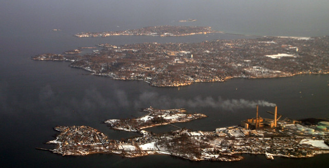
This is the Salem Harbor Power Station, a coal- and oil-fired power plant that's capable of generating 745 megawatts of dirty energy. That's more electricity than could be produced by all of New England's wind turbines, combined, on the windiest day.
The plant occupies a 65-acre site in the middle of historic Salem, Massachusetts. In fact, the plant's mountainous coal supplies - on a typical day, the plant burns over 700 tons - occupy a quay just a couple of blocks away from Nathaniel Hawthorne's birthplace.
According to New England's Conservation Law Foundation, Dominion Energy, the plant's owner, has filed documents to shut down the power plant in the near future. The combination of cheap power from wind turbines and cleaner-burning natural gas plants, combined with increasingly stringent Clean Air Act requirements, seems to be taking its toll on the 60 year-old plant.
This is good news. But New England still has work to do - there are still massive coal-burning power plants operating in our region, in places like Merrimack and Portsmouth, New Hampshire. Together, they send tens of millions of tons of greenhouse gas pollutants into the atmosphere on an annual basis, and these other plants have no closure plans in the works. The massive Brayton Point station in Fall River, Massachusetts, for instance, burns over 2 million tons of coal annually, and sent 148 pounds of neurotoxic mercury into the atmosphere in 2005 alone.
If the progressive and wealthy New England states can't shut down their climate-burning coal power stations, how can we possibly expect the rest of the world to do the same?
Posted by
C Neal
at
5:57 PM
0
comments
file under: energy, global warming
Thursday, October 28, 2010
Marble Hill in Manhattan (not the Bronx)
I recently discovered* Pathological Geomorphology, where various geobloggers share "images of extreme landscapes, landforms, and processes," organized around a monthly theme. Last month was dedicated to landslides, for instance. This month: "the juxtaposition (or superposition) of distinctly human-made landscapes with nature's geomorphic forms."
This immediately reminded me of Marble Hill, a neighborhood in the borough of Manhattan that is physically attached to the Bronx. Here's an aerial view - to orient you, this is the Harlem River ship canal where it curves around the northern tip of Manhattan. A small corner of the Hudson River is in the upper-left corner, and Broadway, and the West Side IRT subway lines, run diagonally from the middle of the bottom edge to the upper right-hand corner:

You can clearly see a looping s-curve through the middle of the picture. It's the old course of the Spuyten Duyvil Creek, which was widened and straightened in the nineteenth century for use as a ship canal between the Harlem and Hudson Rivers. On the left side of the photo is Inwood Hill Park, where I worked as an urban park ranger in 2005. The old creek is still more or less a waterway there, though it's been filled in substantially. The nature center and baseball field at the northeastern entrance of the park (the small peninsula left of center in the photo above) actually used to be connected to the Bronx.
The eastern loop is more interesting. It's been completely filled in - parking lots, warehouses, and big box stores now occupying the former creek bed. But the streets still trace the lines of the historic creek banks. The neighborhood between the new ship canal and the old creek bed is called Marble Hill. It was attached to Manhattan Island until 1895, when the ship canal sliced it off and marooned it as an island. Here's a map from that turn-of-the-century period, via Forgotten New York:

The creek was filled in 1917 to attach Marble Hill to the mainland of the Bronx, but the neighborhood, for political and judicial purposes, remained in New York County, and the borough of Manhattan.
I've heard, anecdotally, that a number of Marble Hill residents still insist on snubbing the borough that surrounds them by telling people they live in Manhattan, which sounds more upscale than the Bronx. So, while the historic geomorphology of the former Spuyten Duyvil Creek does survive to this day in a ghost-pattern of street layouts and land uses, it survives in a more tangible sense in the neighborhood's civic affairs and a general sense of inter-borough snootiness.
Of course, this is probably my best example of how ancient geomorphic forms have influenced human-made landscapes - but I've already written about that one.
*via mammoth, another blog I've discovered and really come to enjoy in the last couple of months - it writes extensively about urban infrastructure and how it relates to our economy and ecologies. If you like this blog, you'll enjoy theirs, too.
This immediately reminded me of Marble Hill, a neighborhood in the borough of Manhattan that is physically attached to the Bronx. Here's an aerial view - to orient you, this is the Harlem River ship canal where it curves around the northern tip of Manhattan. A small corner of the Hudson River is in the upper-left corner, and Broadway, and the West Side IRT subway lines, run diagonally from the middle of the bottom edge to the upper right-hand corner:

You can clearly see a looping s-curve through the middle of the picture. It's the old course of the Spuyten Duyvil Creek, which was widened and straightened in the nineteenth century for use as a ship canal between the Harlem and Hudson Rivers. On the left side of the photo is Inwood Hill Park, where I worked as an urban park ranger in 2005. The old creek is still more or less a waterway there, though it's been filled in substantially. The nature center and baseball field at the northeastern entrance of the park (the small peninsula left of center in the photo above) actually used to be connected to the Bronx.
The eastern loop is more interesting. It's been completely filled in - parking lots, warehouses, and big box stores now occupying the former creek bed. But the streets still trace the lines of the historic creek banks. The neighborhood between the new ship canal and the old creek bed is called Marble Hill. It was attached to Manhattan Island until 1895, when the ship canal sliced it off and marooned it as an island. Here's a map from that turn-of-the-century period, via Forgotten New York:

The creek was filled in 1917 to attach Marble Hill to the mainland of the Bronx, but the neighborhood, for political and judicial purposes, remained in New York County, and the borough of Manhattan.
I've heard, anecdotally, that a number of Marble Hill residents still insist on snubbing the borough that surrounds them by telling people they live in Manhattan, which sounds more upscale than the Bronx. So, while the historic geomorphology of the former Spuyten Duyvil Creek does survive to this day in a ghost-pattern of street layouts and land uses, it survives in a more tangible sense in the neighborhood's civic affairs and a general sense of inter-borough snootiness.
Of course, this is probably my best example of how ancient geomorphic forms have influenced human-made landscapes - but I've already written about that one.
*via mammoth, another blog I've discovered and really come to enjoy in the last couple of months - it writes extensively about urban infrastructure and how it relates to our economy and ecologies. If you like this blog, you'll enjoy theirs, too.
Posted by
C Neal
at
9:29 PM
2
comments
file under: history, NYC, watersheds
Friday, October 15, 2010
The global economy's kyūsho is in Denmark, Maine
The Japanese word kyūsho means vital point, or tender spot - the place where one applies the legendary "death touch" in kung-fu movies.
If you've been reading the news lately, you might be aware that a growing scandal over fraudulent foreclosures is consuming the entire global credit market in uncertainty. I was listening to a report on all this on NPR's "Marketplace" last night, and it occurred to me that, somewhere, there was a family that had been foreclosed on erroneously, fought the bank, and set into motion the events that are bringing credit markets to their knees once again.
In other words, somewhere out there was a single house that was powerful enough to shake the global credit markets to their very core. A kyūsho for the global economy.
And this morning, I found it, via the New York Times. Funnily enough, the house happens to be in the rural municipality of Denmark, Maine, just a few miles from where I grew up.
The Times reports:
Nicolle Bradbury bought this house seven years ago for $75,000, a major step up from the trailer she had been living in with her family. But she lost her job and the $474 monthly mortgage payment became difficult, then impossible.The story goes on to tell of how attorney Thomas Cox found and deposed the bank employee who had signed the foreclosure order. During that deposition, this employee "casually acknowledged that he had prepared 400 foreclosures a day for GMAC [the lender] and that contrary to his sworn statements, they had not been reviewed by him or anyone else."
It should have been a routine foreclosure, with Mrs. Bradbury joining the anonymous millions quietly dispossessed since the recession began. But she was savvy enough to contact a nonprofit group, Pine Tree Legal Assistance, where for once in her 38 years, she caught a break.
The rest is more or less history. "Robo-signers" who approved hundreds of foreclosures a day without even looking at them were exposed nationwide, and foreclosures have now been frozen in 23 states.
This tiny $75,000 house in rural Maine is a lot like Bruce Lee's one-inch punch: we see the mighty banks knocked down, but it's damned hard to see how it happened. Mr. Cox and Ms. Bradbury are like Bruce Lee on the right, and the GLOBAL FINANCIAL SYSTEM is the sad sack on the left:
Ms. Bradbury's case deserves to make her a hero of modern times. It's already set a precedent that's letting thousands of families stay in their homes at the expense of negligent banks. And maybe someday, her humble house in the woods of Denmark will be memorialized as the place that finally foisted honesty on the banking system.
P.S. Pine Tree Legal Assistance, the group that Mr. Cox is volunteering for, is a nonprofit law firm. A judge ruled that GMAC would pay the legal expenses for Mr. Cox's work, but Pine Tree serves a good many clients who can't afford to pay, and here's how you can help them.
Posted by
C Neal
at
7:17 AM
0
comments
file under: economics
Wednesday, October 06, 2010
High-Rise Birdhouses
Artists in London have installed clusters of hundreds of birdhouses on Ailanthus Altissima trees (a.k.a. the Tree of Heaven, Ghetto Palm, or the Tree that Grows in Brooklyn) growing in the terrace gardens various public housing projects.
The high-density birdhousing is meant to mimic the high-density human housing of the surrounding human neighborhood. And also, perhaps, to mimic the proliferation of Ailanthus trees throughout most of the world's cities.
Photo by London Fieldworks.
The high-density birdhousing is meant to mimic the high-density human housing of the surrounding human neighborhood. And also, perhaps, to mimic the proliferation of Ailanthus trees throughout most of the world's cities.
Photo by London Fieldworks.
Posted by
C Neal
at
2:41 PM
1 comments
Saturday, October 02, 2010
Go to Detroit, Young Man, and Grow Up
Bizarrely, a boot company and the guy from "Jackass" have teamed up to debunk the hopeless, epicenter-of-the-recession "ruin porn" that dominates everyone's perception of the Motor City. It's pretty fantastic, so I'll buy into their viral marketing scheme by re-posting and recommending their film here:
Here's the link for the whole 3-part series. It visits some of the famous ruins of Detroit, but only in the context that people are reviving and doing exciting things for those ruins. In this telling, the empty prairies and abandoned buildings don't necessarily represent blight; they represent possibility. Like the frontier in Horace Greeley's day, Detroit offers amazing opportunities for people to reinvent themselves - and reinvent the city.
A lot of what appeals to me in this video reminds me of the things I loved about Houston. Because in spite of its rapid growth and booming economy, Houston (like any other big city) also had a fair share of abandoned buildings, even entire neighborhoods overgrown in weeds, and those were the places I loved to explore.
It was also cheap to live there, partly because Houston has a sprawling geography and very few rules about what people do with their real estate - there is literally no zoning law there.
And so: one man I'd met bought the concrete shell of an old rice mill near the bayou, lived in a bus parked inside its empty walls, and made art cars. Our friends bought an abandoned apartment complex and the old pool hall next door to house a successful after-school program. And the summer we lived there, Art League of Houston commissioned this project for two abandoned houses that had been slated for demolition in the Montrose neighborhood (which is one of the city's most vibrant, by the way):

So in general, the most amazing parts of Houston were the places that had recently been abandoned, and were on the verge of re-creating themselves. I think that the same goes for most cities.
So I guess I disagree, somewhat, with the derogatory term "ruin porn." There are at least a few of us who are ogling Detroit's gorgeous, abandoned architecture and new prairies not out of scorn for the Government Motors bailouts, nor for the sake of wallowing in self-pity about this recession, but out of genuine sense of possibility. We are imagining ourselves making something new there, and being a part of the revival.
Here's the link for the whole 3-part series. It visits some of the famous ruins of Detroit, but only in the context that people are reviving and doing exciting things for those ruins. In this telling, the empty prairies and abandoned buildings don't necessarily represent blight; they represent possibility. Like the frontier in Horace Greeley's day, Detroit offers amazing opportunities for people to reinvent themselves - and reinvent the city.
A lot of what appeals to me in this video reminds me of the things I loved about Houston. Because in spite of its rapid growth and booming economy, Houston (like any other big city) also had a fair share of abandoned buildings, even entire neighborhoods overgrown in weeds, and those were the places I loved to explore.
It was also cheap to live there, partly because Houston has a sprawling geography and very few rules about what people do with their real estate - there is literally no zoning law there.
And so: one man I'd met bought the concrete shell of an old rice mill near the bayou, lived in a bus parked inside its empty walls, and made art cars. Our friends bought an abandoned apartment complex and the old pool hall next door to house a successful after-school program. And the summer we lived there, Art League of Houston commissioned this project for two abandoned houses that had been slated for demolition in the Montrose neighborhood (which is one of the city's most vibrant, by the way):
So in general, the most amazing parts of Houston were the places that had recently been abandoned, and were on the verge of re-creating themselves. I think that the same goes for most cities.
So I guess I disagree, somewhat, with the derogatory term "ruin porn." There are at least a few of us who are ogling Detroit's gorgeous, abandoned architecture and new prairies not out of scorn for the Government Motors bailouts, nor for the sake of wallowing in self-pity about this recession, but out of genuine sense of possibility. We are imagining ourselves making something new there, and being a part of the revival.
Posted by
C Neal
at
9:10 PM
0
comments
file under: Detroit, Houston, succession, the built environment
Sunday, September 26, 2010
A Natural History of Playgrounds
For some time now, I've been meaning to write something here about playgrounds, which are substantial components in the natural areas and parklands of most cities worldwide.
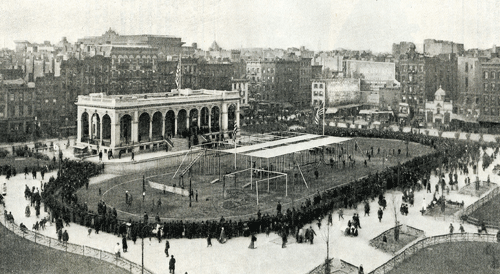
I was first inspired by Rebecca Mead's "State of Play" feature in a July issue of the New Yorker. That article is mostly about a new generation of "imagination playgrounds" that are beginning to appear in Manhattan, but Mead begins her article with a description of the rainy opening day at the Lower East Side's Seward Park Playground, the first ever municipally-built playground in the United States:
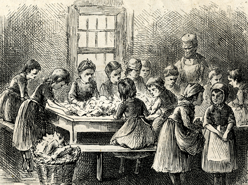
Children stripping tobacco, from "The Little Laborers of New York City,"
Harper's New Monthly Magazine, August 1873.
Mayor Low was one of the first New York City mayors of the progressive era and an anti-Tammany Hall reformer. The playground he opened reflected a philosophy of social reform, that children "have a right to play," and that they needed opportunities to escape the crowded conditions of the tenements.
Seward Park had a lot of the ingredients we associate with playgrounds today: open fields, slides, monkey bars, swings, and sandboxes.
Seward Park at the corner of E. Broadway, Canal, and Essex Streets in 1912. Image from the Library of Congress.
In photographs, the playground equipment of 1903 looks incredibly dangerous to my modern eyes:
The height of those high monkey bars remind me that eugenics for the lower classes was also a progressive era fad that the playground's designers might, possibly, have had in mind. But that's probably just my paranoid perspective as someone who is both afraid of heights and living in a litigious society.
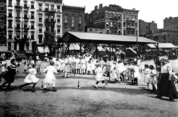
In addition to the play equipment, which was designed to encourage vigorous physical activity, the playground also had designated park employees who would lead children in athletic games, segregated by gender. In this 1908 photo from the Parks Department archives, a Seward Park employee leads a group of girls in something called a "Ten Pin Pursuit Race":
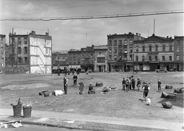
So, in spite of the chaos of the opening day, the city's first playground was clearly designed and programmed to control the playing behavior of the lower-class neighborhood's kids, who had been overrunning the streets in rough reenactments of Spanish-American War battles, and playing in the filth of the city's vacant lots.
This is a theme of playgrounds that continues to this day. Just last week, I attended a neighborhood meeting about a proposal to build fancy new basketball courts next to one of Portland's larger public housing complexes. The phrase "get kids off the streets" came up several times, even though, if the goal is to get troublemakers off the streets, some kind of playground for middle-aged alcoholics might be more useful.
Every park is the product of human values and physical interventions. Even our most remote, backcountry "wilderness" areas are shaped by hiking trails, fire policy, and the historical extirpation of native peoples by military force.
But playgrounds take the physical manifestation of our social values in the outdoors to the extreme. They're the section of a city park where nearly all plants have been removed and the soil itself has been replaced with a kind of soft, antiseptic ground cover (usually wood chips, or sometimes a kind of rubberized pavement). The way playgrounds are designed - how they dictate the terms of how children play - are a faithful reflection of a city's hopes and anxieties for the next generation.
A century later, Seward Park still exists in the Lower East Side, and there's a newly-renovated playground there. It is strikingly less vertical than the first one, and probably safer. But there is no mob of twenty thousand children, breaking down the fences, desperate to start playing.
I was first inspired by Rebecca Mead's "State of Play" feature in a July issue of the New Yorker. That article is mostly about a new generation of "imagination playgrounds" that are beginning to appear in Manhattan, but Mead begins her article with a description of the rainy opening day at the Lower East Side's Seward Park Playground, the first ever municipally-built playground in the United States:
"By 2 p.m., when the opening ceremony was scheduled to begin, twenty thousand children had swarmed the playground and its surrounding streets, climbing on rooftops and fire escapes for a better view of the seesaws, swings, and sandboxes... Eventually, the kids stormed the park gates, overwhelming two hundred police officers who were trying to keep order. 'They swept around and through the policemen, and, without pausing, leaped over the iron fence about the playground,' the Times reported the next day...Now that playgrounds have become a common feature in every city, town, and schoolyard in the nation, it's hard to imagine how the opening of one could inspire a riot of 20,000 children. But in 1903, when Seward Park opened, the Lower East Side was packed solid with poor immigrant families whose children worked from an early age.
Mayor Low did speak, although the noise of the crowd was such that only those in his immediate vicinity could hear what he had to say: 'The city has come to realize that it must provide for its children, that they have a right to play as well as to work.'"-Rebecca Mead, "State of Play"
Harper's New Monthly Magazine, August 1873.
Mayor Low was one of the first New York City mayors of the progressive era and an anti-Tammany Hall reformer. The playground he opened reflected a philosophy of social reform, that children "have a right to play," and that they needed opportunities to escape the crowded conditions of the tenements.
Seward Park had a lot of the ingredients we associate with playgrounds today: open fields, slides, monkey bars, swings, and sandboxes.
In photographs, the playground equipment of 1903 looks incredibly dangerous to my modern eyes:
The height of those high monkey bars remind me that eugenics for the lower classes was also a progressive era fad that the playground's designers might, possibly, have had in mind. But that's probably just my paranoid perspective as someone who is both afraid of heights and living in a litigious society.
In addition to the play equipment, which was designed to encourage vigorous physical activity, the playground also had designated park employees who would lead children in athletic games, segregated by gender. In this 1908 photo from the Parks Department archives, a Seward Park employee leads a group of girls in something called a "Ten Pin Pursuit Race":
This is a theme of playgrounds that continues to this day. Just last week, I attended a neighborhood meeting about a proposal to build fancy new basketball courts next to one of Portland's larger public housing complexes. The phrase "get kids off the streets" came up several times, even though, if the goal is to get troublemakers off the streets, some kind of playground for middle-aged alcoholics might be more useful.
Every park is the product of human values and physical interventions. Even our most remote, backcountry "wilderness" areas are shaped by hiking trails, fire policy, and the historical extirpation of native peoples by military force.
But playgrounds take the physical manifestation of our social values in the outdoors to the extreme. They're the section of a city park where nearly all plants have been removed and the soil itself has been replaced with a kind of soft, antiseptic ground cover (usually wood chips, or sometimes a kind of rubberized pavement). The way playgrounds are designed - how they dictate the terms of how children play - are a faithful reflection of a city's hopes and anxieties for the next generation.
A century later, Seward Park still exists in the Lower East Side, and there's a newly-renovated playground there. It is strikingly less vertical than the first one, and probably safer. But there is no mob of twenty thousand children, breaking down the fences, desperate to start playing.
Posted by
C Neal
at
1:00 PM
1 comments
file under: history, recreation
Tuesday, September 07, 2010
How I Spent My Unemployed Vacation
Last fall, with a month to spare between jobs, I spent a week hiking through Maine's Hundred-Mile Wilderness on a freelance assignment from Maine magazine. It's just been published in their September issue, and illustrated with photos by Craig Dilger. Here's a short excerpt:
...right before our group descended below the tree line, a gust of wind suddenly cleared away the clouds. All at once, the vast forest across which I had trekked over the past week lay spread out below us under remnant wisps of valley fog: wrinkled piles of mountain ridges streaked with yellow birches, red sugar maples, boreal greens, and shimmering ponds.
From up here, it certainly looked like a wilderness. But that name glosses over the complexities of this landscape: it’s a solitary place populated with personable people, and a wild place entangled in the often oppositional industries of tourism and forestry.
Read it online if you're from away and can't find the magazine at a newsstand. Otherwise, buy a copy on paper, because this issue also contains writer Chelsea Holden Baker's and photographer Mark Marchesi's amazing profile of the people and businesses that wrangle huge oil tankers in and out of Portland's harbor.
Posted by
C Neal
at
3:40 PM
4
comments
file under: indulgent self-reference
Subscribe to:
Posts (Atom)