Tuesday, June 08, 2010

The Geotaggers' Atlas


On the photo sharing websites Flickr and Picasa, users can "geotag" their photographs with specific longitude/latitude coordinates on a map, as a way of organizing their own collections and seeing other photographers' images of the same neighborhoods.

Geographer Eric Fisher has mined this data using the sites' public APIs to create the "Geotaggers' World Atlas," a collection of maps of 100 major global cities, overlaid with points representing where users have posted their photographs. The resulting images are fascinating, information-rich portraits of the places where photographers (or, more precisely, web-savvy photographers who upload their photos and tag them with geographical data) congregate.

Thus, the map of London shows dense concentrations of photos in the central business district, but also in Greenwich and Canary Wharf (the two blobs near the east side of the map), in Kew Gardens (on the west side), and along the city's principal streets. The banks of the Thames River are clearly delineated as well, and criss-crossed by dense clusters of photographs taken on the city's bridges:


Other maps reveal more about where digital photographers who use Flickr and Picasa are likely to live and hang out. Here's Portland, Oregon, a city I'm familiar with from my college days at Reed College:

As in London, the banks of the Willamette River are clearly delineated in the downtown area, where there's a popular park on the western bank and a bike path on the eastern bank, as are the city's bridges. The horizontal line just south of downtown is the city's new aerial tramway, a photogenic segment of the transit network that connects the riverfront to the Oregon Health Sciences University complex high above in the city's West Hills.

A small knot of photos on the east side of the map represents Mount Tabor Park. Between there and downtown stretches Hawthorne Boulevard, a business-lined Main Street that runs all the way to the Hawthorne Bridge into downtown. You can also make out North Mississippi Ave., plus Killingsworth and Alberta Streets, north of downtown. These neighborhood Main Streets aren't particularly dense areas of the city, nor are they tourist magnets. But they are the business and entertainment districts for gentrifying neighborhoods where Flickr's young, web-savvy users like to hang out and take digital pictures of their friends.

These maps can also say a lot about a city's distinctive way of life. Here's Istanbul:
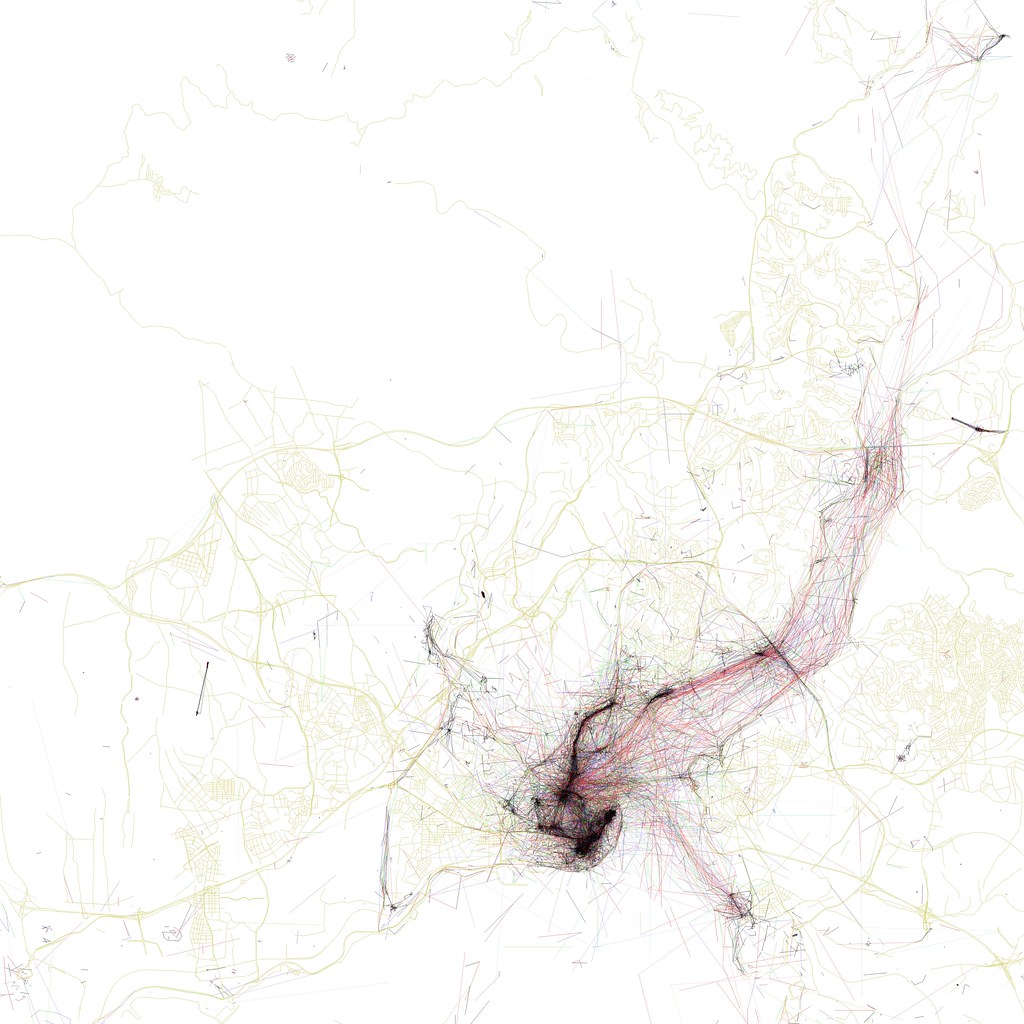
The dense quadrangle in the bottom-center of the photo represents the city's major tourist sites: clockwise from the western corner, they are the Grand Bazaar, the waterfront near the Spice Bazaar, the palace complex, Hagia Sofia, and the Blue Mosque. Extending north from the Spice Bazaar is a dense cluster of photos across the Galata Bridge, up the hill past the Galata Tower, and along the arc of İstiklal Cadessi, a major nightlife and shopping district.

But unlike other cities, Istanbul's map is defined less by streets, and more by the broad waterways that separate its neighborhoods. From the Golden Horn (the central peninsula at the bottom-center of the map) emanates a web of photographs and multiple-exposure photo paths taken from ferries and other boats traveling along and across the Bosporus straits. Clusters along the shore represent ferry terminals at Beşıktaş, Harem, and other neighborhoods. Istanbulites clearly spend lots of time on boats, and like to pass the idle time on the water by snapping photographs.

More recently, Fisher has updated a number of these maps to differentiate photos from tourists and photos from locals (his methodology: if a photo comes from someone who is still geotagging photographs in the same city within 30 days, it qualifies as a "local"). These "Locals and Tourists" maps add another layer of information to distinguish the places where tourists go from the places that locals find to be the most interesting.

Here's New York. Red dots represent "tourist" photographs; blue dots are from locals, yellow dots could be either:

Ellis Island and the Statue of Liberty stand out as bright red clusters in the lower left corner, connected to the red Battery at the southern tip of Manhattan by a dense web of photos from ferry rides. Just to the right is the blue, teardrop-shaped outline of Governor's Island, a newly-opened park that seems not to have caught on yet with visitors, which is itself just above a blue cluster around Red Hook, another neat neighborhood that is definitely far from the tourists' beaten track.

There's a lot of red in midtown Manhattan, especially along 34th Street (the Empire State Building), 42nd Street (with Times Square, Grand Central, and the UN on the East River), around Rockefeller Center, and in the southern reaches of Central Park. Locals predominate along the avenues of the upper west side, in Riverside Park along the Hudson River, in the Lower East Side, and in the Brooklyn neighborhoods of Park Slope, Fort Greene, and Williamsburg, as well as in the old World Fair grounds in eastern Queens. And note the small cluster of red and blue dots around Yankee Stadium in the Bronx (in the upper center of the map) and around the Meadowlands sports arenas over in New Jersey (on the left edge of the map).

And here's San Francisco. Can you spot Alcatraz?

San Francisco is the center of the metro area where both Flickr and Picasa have their headquarters - apparently a lot of their employees and enthusiasts live in the Castro and Mission districts (the dense blue grids just south of downtown).

What I really like about the Locals and Tourists maps is the possibility of using them as a tourist's guide to un-touristy places. If I were going to Washington, for instance, I might want to cut short the sightseeing on the Mall to check out those blue clusters north of Dupont Circle around Meridian Hill Park, or see what the locals find so photogenic about the Potomac River in Georgetown. The Space Needle is clearly popular among visitors to Seattle, but maybe my time there would be better spent finding out why the locals take so many pictures around East Union and North 45th Streets.

Using the maps this way might be particularly useful in Paris, where there's evidently no shortage of photos of the Eiffel Tower. Parisians seem like the kind of people who'd be a lot more friendly and welcoming to visitors who don't contribute to the mobs around the Louvre and Île de la Cité and are brave enough to venture to the more genuine parts of the city. The 19th and 13th arrondissements look promising.

That said, I've also never been to Alcatraz myself, and I'd like to go. Most tourist destinations attract visitors for good reasons - but these maps demonstrate that there are plenty of off-the-beaten-track neighborhoods that are worth visiting as well.

Maybe Fisher will share his secret coding techniques with the rest of us so we can produce maps of our own - I'd be especially curious to see Locals/Tourist maps of the east-coast Portland, and of Houston.

It would also be interesting to slice this data in other ways, in addition to Fisher's clever tourist/locals divisions. For instance, what if we separated out the photos that were taken on weekends from photos that were taken on weekdays? Or map only photos taken between 9 pm and 3 am, to generate a diagram of cities' best nightlife neighborhoods? You could even go so far as to analyze the light and color balances of these photographs and generate maps of places where people go on gray rainy days, versus places where people go to photograph blue skies, versus favorite destinations on white snowy days.

In the meantime, both the Geotaggers' World Atlas and the newer Locals and Tourists maps are very much worth browsing, although, like me, you may lose hours to scrutinizing the richness of their information.



Tuesday, June 01, 2010

A Park Gained, A Wilderness Lost

When I was in New York a few weeks ago, I finally made a visit to the High Line, the city's new park on an abandoned elevated rail line on the west side of Manhattan.

The High Line, in 2007 and in 2010 on TwitpicLeft: the High Line in 2007 and in 2010: cultivating native plants and overpriced condo towers. Click to enlarge.

I had been pretty excited about this park for a long time - I first learned about it in 2006, the year I was working for the City as an Urban Park Ranger, when the project first broke ground. For me, the High Line was a vindication of my idea that a city's hidden pockets of wildness - often on the forgotten margins, like the abandoned industrial neighborhood around the High Line - could be celebrated for their unique ecosystems and natural resources, instead of being condemned as "blight."

Since it's opened to the public, there can't be any doubt that this abandoned railroad has been a cause for celebration from residents and tourists alike.

But when I visited last month, I had to wonder if something was lost in the High Line's transition from abandoned railroad to public park. The High Line is stunningly designed, packed with native plantings, and it's opened up new ways for New Yorkers and visitors to experience the city.

But is it wild anymore?


The High Line in 2001, by Jonathan Flaum:And in 2009, via Inhabitat:


The overwhelming impression I got from walking on the High Line this spring was of wealth. The park was clearly expensive to build, with tropical-wood furniture, elaborate fountains (they were under repair while I was there), and meticulously tended foliage. The carefully selected varieties of native plants were evenly, geometrically spaced in mulched planting beds outfitted with an irrigation system. A forest of new condo high rises and hotels, designed by global celebrity architects, loomed over the rehabbed warehouse buildings of the former industrial district.

Great architecture is all well and good. But I found that the High Line, in its "finished" state, was less like the wilderness I'd hoped for, and more like a formal garden for the gentry of Chelsea: a sort of post-industrial Versailles.

I feel like this is a missed opportunity. After all, ostentatious displays of wealth in New York City are not all that compelling or interesting - they're pretty much a dime a dozen.

The High Line, before it was a park, had been a refuge from a landscape obsessed with capitalizing and selling every square foot of space. Here there were acres of land that existed outside of the consciousness of real estate, where weeds, small mammals, birds, and the occasional human adventurer were free to wander in a two-mile meadow, simultaneously above and surrounded by the city. That's where it derived its wildness.

As a landscaped park, though, the High Line is obviously a real estate amenity. When every prospect offers views of shiny condo towers and expensive lofts in expensively rehabbed warehouses, and designer signage implores you to stay on the designer concrete pathway, it's obvious to the visitor that this park was financed and built by developers and neighbors angling to increase their own property values. In the process of becoming a public park, the High Line became co-opted by New York City's real estate juggernaut.

In the process, an essential part of the High Line's promise - its freedom, and isolation from the commodification and control of New York City's landscape - has been lost.*

The new High Line park's design also botches the structure's historical context. Until 1980, the High Line railroad had been used to deliver agricultural raw materials to various food processing plants in the neighborhood. Refrigerated boxcars full of cows, for instance, were delivered to the slaughterhouses of the Meatpacking District. Several spurs curve from the main line into adjacent buildings, and in some places, the High Line actually travels through the middle of buildings, with old loading docks on either side.

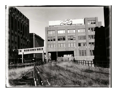
Here's a photo from the mid-twentieth century of the High Line where it runs through the National Biscuit Company (a.k.a Nabisco) complex. These are the same buildings pictured at the top of this post:


For decades, then, the High Line (and its surrounding neighborhood) played an important role in feeding New Yorkers, and commodifying the agricultural bounty of the Midwest into value-added processed foods. There's a rich historical narrative here about the industrialization of agriculture, the centralization of food processing, the rise of supermarkets... but there's no trace of any of this in today's High Line Park.

This was the other big thing that unnerved me about walking along the High Line. The structure's wrought-iron railings, steel I-beams, and the handful of high-ceilinged brick warehouses surrounding the old railway clearly hearken back to a lost industrial past. But everything about the park itself, and the expensive architecture that surrounds it, drives home the fact that that industrial past is entirely gone. This used to be a neighborhood that made things and trafficked in the heavy, bulky products that required massive railroads to move. The High Line itself used to be a vital connection between the City and the natural resources that fed it.

But today, the neighborhood traffics in abstractions: there's tremendous wealth here, but it's anyone's guess where it comes from.

Back in 2007 I wrote about how the abandoned High Line illustrated the ecological succession of urban vacant lots
:
Over the years, more dust, leaves, and soot blew in. Each fall, the topsoil gained another layer of dead grass and leaves from pioneer weeds like goldenrod, Queen Anne's lace, and Ailanthus Altissima... the new High Line park will have benches, new concrete paths, easy access from the street level, and drought-tolerant landscaping that mimics the wild weeds that inspired the park.

It might seem like an interruption and commodification of the wild successional process, but New York is nothing if not habitat for homo sapiens, and the new High Line fits in perfectly with New York's typical neighborhood succession: places once run-down and diverse inexorably become unaffordable and boring. At least until the next large disturbance, anyhow.
When the new park opened in 2009, we were in the middle of a huge financial crisis that seemed to hold out the promise of being that "next large disturbance." Here's an excerpt of the post I wrote at the park's grand opening:
In the new economy, the High Line feels a lot weirder. It was meant to be a futuristic preserve for New York's past - especially its overgrown lots and abandoned industrial infrastructure. Now that the park is open, though, the ultra-slick High Line feels a bit out of place. Instead of evoking New York City's past, the High Line looks more like an expensive simulation of conditions in inner-city Detroit, or of a foreclosed backyard, or of any of the thousands of newly-defunct car dealerships nationwide. Those conditions were rare in New York City two years ago, but now that they're fairly commonplace in society's consciousness, the High Line seems more artificial and contrived.
Now that I've been there, though, I realize that the High Line doesn't feel anything like Detroit or an abandoned car dealership. That's its problem: it lacks any relationship to the economic or environmental conditions of the city. Instead, it sits aloof from the street, a walled garden guarded against the weeds and the history that used to reside there.

But the views are nice, I'll grant it that.


*Footnote: This is related to the age-old debate about whether we can open up "wilderness" areas to the public without ruining the essential qualities that make these areas feel wild - namely, their isolation and freedom. I'm typically inclined to believe that this is not a real trade-off, especially if we can help people appreciate the relative abundance of places like the (old) High Line that exist right under our noses, in our cities and neighborhoods. Cultivating a sense of stewardship for these places, whether they're in an abandoned downtown area or in a national park, will let more people enjoy them without necessarily "ruining" them.

Unfortunately, in the case of the High Line, we (the public) have surrendered our responsibilities of stewardship to profit-motivated architects and developers.


Sunday, May 30, 2010

That Fresh Forest Air

There's a faint smell of smoke hanging in the hazy air this morning here in Portland. I went to a local diner for breakfast and asked if there had been a fire somewhere in the city overnight, but nobody knew of one. Besides, it doesn't have the harsh, metallic odor of a burning building; it's a more woody smell, like a brush fire.

And indeed, that's what it appears to be. This morning's northwesterly winds seem to be carrying a plume of wood smoke across hundreds of miles, from forest fires in the boreal woods of Quebec and eastern Ontario.

Maine's Air Quality Forecast is predicting "Moderate - Limited Health Notice" levels of particulate pollution statewide today, with this explanation:
"Particle pollution values are very high this morning from smoke due to fires in the Province of Quebec. A number of these fires continue to burn out of control. Brisk northwest winds will be directing the smoke and particle pollution toward Maine today. Normally brisk winds cause a lot of mixing and the pollution levels lessen. However, the levels are so high that this turbulence will not be able to completely drop particle pollution levels. In addition, these brisk winds could easily cause these fires to burn more strongly."
As of 9 am, though, particulate pollution levels in Portland had exceeded 50 micrograms per cubic meter - a reading that far exceeds "Moderate" levels and approaches the code-red "Unhealthy" status in the federal Air Quality Index.

It's just my luck that I came down with a serious sore throat yesterday - this morning's bad air isn't helping matters.

Elsewhere in the nation, smoke from agricultural burns in the Mississippi River valley and the upper midwest is also blowing into cities across the southeast and midwest. At right is a snapshot of surface smoke in New England at 11 am today, courtesy of the National Weather Service's excellent Air Quality forecasting site.

Visit this link watch the smoke creep towards the ocean over a 12-hour loop of satellite images (choose "1 hour average surface smoke" from the drop-down menu).

Thursday, May 20, 2010

The Real Dr. Frankenstein: Artificial Life Is Here

As of today, artificial life is real. Craig Venter, one of the founding fathers of genomics, has successfully created a new life form built from scratch from a synthetic, engineered genome.

According to Earth2Tech, "The researchers built a synthetic chromosome and inserted it into a living bacterial cell, where it — for the first time and published in the journal Science today — took over the cell and became a new life form."

So the world's first man-made life form is also a body-snatcher.

Venter's research is being funded largely on the hopes that it will produce new organisms to help convert sugars into ethanol, or to engineer a new algae that not only absorbs CO2, but also could be used as a transportation fuel. In fact, Venter's startup, Synthetic Genomics, Inc., has been operating in partnership with ExxonMobil's research and development office.

There's a strain of environmentalism that believes that climate change is catastrophic and unavoidable, and the best option for us now is not to reduce greenhouse gas emissions, but to embark on large-scale "geo-engineering" projects to reverse-engineer the Earth's atmosphere into a cooler state. Ideas range from pumping smoke into the upper atmosphere to give us more shade, to seeding the oceans with iron to promote plankton growth.

These ideas horrify mainstream environmentalists because there's nothing to indicate that these ideas would work, or that they wouldn't inflict serious unforeseen consequences. To me, the worst thing about the geo-engineers is that they think it's a good idea to spend a lot of money and exert massive efforts in order to treat the symptoms of climate change - not the causes.

It seems to me that Dr. Venter's devotion to synthetic life has too much in common with the geo-engineers' perspective, even though his work is on a microscopic (instead of planetary) scale.

It's a huge effort, a science-fiction fantasy come to life, and for what? So we can fuel our minivans with the world's agricultural crops instead of with oil. Thanks, science - I guess.


Wednesday, May 19, 2010

Loop Current

In 1992, a container ship crossing the Pacific Ocean from China lost its cargo of nearly 29,000 rubber duck toys during a winter storm. In the nearly two decades since then, the toys - easily identified by the "First Years" brand name etched in the plastic - have washed up on the shores of Alaska, Chile, and Australia, drifted through Arctic pack ice, and - as of 2007 - started showing up on the shores of Europe.

But what could have been another banal contribution to the Pacific Garbage Patch instead became a valuable scientific experiment. Oceanographer Curtis Ebbesmeyer has been spending the past two decades keeping track of where the rubber toys end up, and when, for a detailed insight into the nature of ocean currents.

Now, another petroleum-based consumer product is giving us a real-time lesson on how ocean currents work in the Gulf of Mexico. Here's a satellite view of the big oil slick from Monday, via NASA's Earth Observatory:


See that long tendril of an oil slick stretching out towards the southeast? That's the Gulf Loop Current, and here's where it's taking the oil next (via the Palm Beach Post):


Wednesday, May 12, 2010

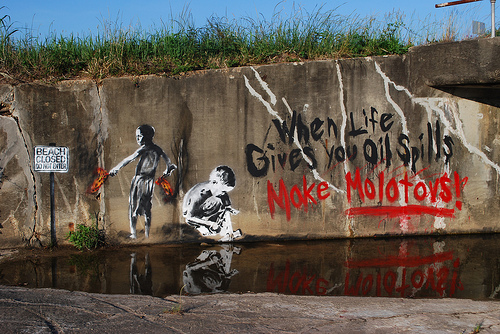
When life gives you oil spills...

New street art from Priest, via Wooster Collective.

Thursday, May 06, 2010

Disaster and Responsibility

At the beginning of this week, Paul Krugman wrote about the Gulf's oil spill as an old-fashioned, photogenic environmental disaster, one that might finally spur America's leaders to grow a backbone and fight for clean energy:
Environmentalism began as a response to pollution that everyone could see. The spill in the gulf recalls the 1969 blowout that coated the beaches of Santa Barbara in oil. But 1969 was also the year the Cuyahoga River, which flows through Cleveland, caught fire. Meanwhile, Lake Erie was widely declared “dead,” its waters contaminated by algal blooms. And major U.S. cities — especially, but by no means only, Los Angeles — were often cloaked in thick, acrid smog.

It wasn’t that hard, under the circumstances, to mobilize political support for action... [yet] as visible pollution has diminished, so has public concern over environmental issues. According to a recent Gallup survey, “Americans are now less worried about a series of environmental problems than at any time in the past 20 years.”

This decline in concern would be fine if visible pollution were all that mattered — but it isn’t, of course. In particular, greenhouse gases pose a greater threat than smog or burning rivers ever did. But it’s hard to get the public focused on a form of pollution that’s invisible, and whose effects unfold over decades rather than days.
So suddenly we have a very visible reminder of why we need alternatives to oil. Some good could come of this, right?

But there's a big problem with this line of reasoning. As terrible as this oil spill has been, and will be, the scale and impacts of this disaster don't come anywhere near the scale and impacts of global climate change. They are separate problems.

True, oil has been a trigger for both problems, and therefore, Krugman reasons, they might share a common solution: generate more clean energy, burn less oil.

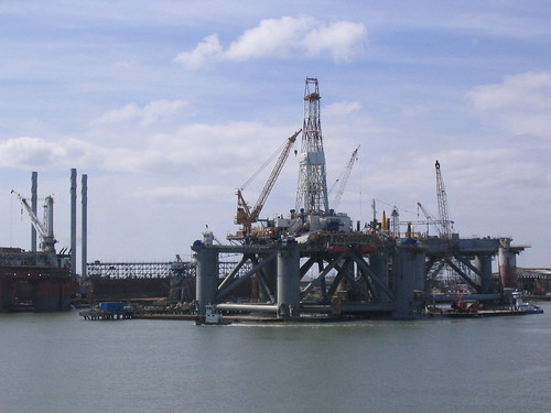
Oil rigs under construction in Galveston, Texas in spring 2008.
These are huge, tremendously complex and expensive machines. BP may have been the organization responsible for the Deepwater Horizon rig, but we - the American motoring public - were the financiers.

But the fact that global warming and this oil spill are very different problems also means that they don't necessarily have to share the same solution. In fact, the dominating conclusion that people on the left have been jumping to is one that actually won't do a damn bit of good for the climate in the long term.

That knee-jerk "solution" is to ban offshore drilling, without doing much of anything to reduce our energy use or develop alternatives. This addresses the visible part of the disaster - the part that Krugman sees as the biggest opportunity. But it doesn't do anything to address the more insidious, less visible threat of climate change.

Attendant with this has been a lot of facile political mockery of the "drill baby drill" contingent. This may be fun, but it's not especially productive. The oil spill is creating a political spectacle as well as an environmental one:


Lisa Margonelli, an expert on oil supplies, explained one of the big problems with these reactions in a thoughtful New York Times op-ed last weekend:
Whether this spill turns out to be the result of a freakish accident or a cascade of negligence, the likely political outcome will be a moratorium on offshore drilling. Emotionally, I love this idea. Who wants an oil drill in his park or on his coastline? Who doesn’t want to punish Big Oil on behalf of the birds?

Moratoriums have a moral problem, though. All oil comes from someone’s backyard, and when we don’t reduce the amount of oil we consume, and refuse to drill at home, we end up getting people to drill for us in Kazakhstan, Angola and Nigeria — places without America’s strong environmental safeguards or the resources to enforce them.
It's worth noting that this disaster is happening in the Gulf Coast because the poorer states of the Deep South share a predilection for weak environmental laws, and therefore their coastlines are the only place in United States waters where drilling is allowed. Plenty of people who find drilling distasteful are only too happy to burn the fruits of the Gulf Coast's rigs and refineries: see "Exporting Pollution to Dixie," from December 2007.

Margonelli goes on to suggest that "we should throw our newfound political will behind a sweeping commitment to use less gas." But that, of course, would require more than political will: it would require environmentalists to set aside our Palin-bashing, "we told you so" grandstanding to actually accept our own personal responsibility for the oil we use, and do something foresighted and intelligent.

It would also require us all to share culpability for this oil spill, by acknowledging that everyone who burns gasoline shares responsibility for the thousands of oil rigs in the world's oceans, and the risks that those rigs create for our environment.

Personally, I'm not holding my breath for that outcome. Earlier in the same column, Margonelli notes that BP's ludicrous "Beyond Petroleum" slogan had been extremely successful, in part, because it "accurately reflect[s] drivers’ desire to buy unlimited gasoline while remaining 'beyond' all the mess" [side note: you may recall that BP was also the force behind Los Angeles's "green" gas station a few years ago].

The facile fantasies that banning offshore drilling will save our environment, or that it's all Sarah Palin's fault, are inextricably linked to the fantasy that driving hundreds of miles every week can ever be "sustainable" - the fantasy of the 20th-century American Dream.

Put another way: it's a lot easier to caricature evil corporations and score political points against stupid Republican slogans than to examine the lifestyle we take for granted, take personal responsibility for it, and work to change the economy that spends trillions of dollars to squeeze oil from our oceans.

It is "Commute Another Way" month, if anyone's interested in burning a little less oil.

Anyone?

Tuesday, May 04, 2010

Spill, Baby, Spill

Two weeks ago, my wife and I spent a weekend in Port Aransas, Texas for our the wedding of Katy and Zach, who love the beach as well as each other. For our first two days there, it was hazy and muggy and difficult to see very far. Still, in the evenings we could see lights out at sea.

But on the third morning, rain showers had cleared the air. When we looked out to the ocean, we were suddenly able to see dozens of oil rigs and platforms scattered along the horizon, as though they had just appeared overnight.

Port Aransas drilling platforms, by Flickr user austrini.

It might be because I grew up in Maine, but looking out at the ocean has never really inspired a sense of awe in me, the way it seems to for others. But seeing the oil rigs at Port Aransas made me feel differently. Looking at these huge machines as tiny blips on the horizon really impressed me with how huge the ocean really is. Each of these rigs had crews that would be flown in by helicopter to live there for month-long shifts. They're tiny villages isolated by miles and miles of ocean, like outposts on a watery and hostile prairie.

But the biggest feeling of awe didn't come from contemplating the vast ocean. It came from contemplating the tremendous wealth and social complexity necessary to plant thousands of these rigs and their crews miles out to sea.

A map of offshore oil and gas platforms in the Gulf of Mexico, from Wikipedia.

From Port Aransas we drove through a landscape of ride fields and petrochemical refineries to Houston, home to the headquarters of most major oil companies doing business in the United States, including BP. While we were there, BP's Deepwater Horizon drilling rig, operating in deep waters beyond the edge of the continental shelf, exploded and sank to precipitate what could become the worst oil spill in history.

But in those first few days, there wasn't much to indicate that it would be such a disaster. With thousands of oil rigs operating in the Gulf, accidents are inevitable. At the airport the next morning, we read through a discarded copy of the April 21st Houston Chronicle. I remember noting that the newspaper was lighter and smaller than it had been five years before, when I'd lived in Houston. But I don't remember any stories about the Deepwater Horizon. We wouldn't know the scale of the disaster until later. We probably still don't know.

How we respond reveals a lot about the state of environmentalism, energy policy, and our economy. I have a lot more to say on this - in the meantime, here's an old post about my visit to the Texas Star offshore oil rig museum in Galveston: