Wednesday, December 27, 2006

Plum Creek's economic benefits: a closer reading

This past weekend, the Maine Sunday Telegram published an op-ed column I'd written about the economic benefits of Plum Creek's plan for the Moosehead region. The article is reprinted in full here at the Natural Resources Council of Maine webpage.

The Telegram gave it the misleading headline "Plan no benefit to region's economy." I argued that the plan does provide some much-needed economic benefits to the region; however, most of those benefits come from investments in the region's forest and tourist industries. The most controversial aspects of the plan - the hundreds of houselots scattered across the wilderness - would contribute little, and might actually detract from, the region's economy.

The graph below shows the expected income, in thousands of dollars, from residential development of house lots compared with expected income from one industrial forest products facility (source: Dr. Charles Colgan, "Estimated Economic Impacts...", 2006):

Note how income from hundreds of house lots plunges to zero after peaking in 2015, while the income from one sawmill rises and exceeds construction income every year. Also, though Colgan doesn't break it down by individual counties, it's widely expected that most of the construction income from residential development will go to construction firms and workers from outside of the Moosehead region (mostly in Bangor, in Penobscot County). The bulk of industrial income, on the other hand, will go to long-term employees living within a feasible commuting distance of the mill, which is proposed to go on the road between Greenville and Rockwood.

Then there's the fact that the sawmill will have fewer demands of municipal services than nine hundred seventy-five new houses. And all of those houselots are going to take thousands of acres of productive forest land out of production, off-limits to the much more lucrative businesses of forestry and recreation.

So yes, Plum Creek's plan does have some economic benefits. But those benefits would be a lot less ambiguous if the company stuck to the business of forestry and struck the wilderness housing developments from its proposal.

Thursday, December 21, 2006

New York still stands, and thinks to look ahead

Twenty-five years ago, New York was almost bankrupt. Robert Caro had written a book subtitled "The Fall of New York" and won a Pulitzer Prize for it. And the new movie "Escape from New York" was premised on the idea that by 1997, Manhattan would be abandoned and adaptively reused as a maximum-security prison.

In hindsight, New York didn't fall. In fact, the city is worth trillions of dollars and is basically ruling the planet. And so, flush with cash and ambition, the city is looking to the future with an optimism it hasn't had in decades.

The Bloomberg administration articulated that optimism last week with PLANYC 2030. The Plan anticipates that "our city will be getting bigger, our infrastructure older, and our environment more unpredictable" (the last is a reference to global warming, which could soon turn downtown New York into a Venice of the New World). These three broad issues are broken down into ten goals sorted under one-word headlines, which, for the sake of print design, all end in the letter "N" (for NYC, get it?).

Under the "OPENYC" initiative, the goals are to build housing for one million new residents, add transit capacity to serve them and improve travel times, and to insure than every New Yorker lives within a 10-minute walk from a park. Goals of the MAINTAINYC initiative deal with upgrading the city's water, transportation, and electicity infrastructure. And the four goals of GREENYC are to reduce climate-change pollutants by 30%, to have the cleanest air of any large American city, to clean all of New York's contaminated brownfields, and to open 90% of city waterways to recreation with natural area restoration and water quality improvements.

In spite of the references to "opening" and "maintaining" the city, every one of the ten goals involves making New York, and by extension, America, more sustainable. The plan claims that "New York is one of the most environmentally-efficient cities in the world." The world can disagree, but certainly NYC is the most efficient place to live in the United States. Imagine how much worse off we would be if New York's 8.5 million people - almost 3% of the nation's population - lived the same SUV-driving, McMansion-living lifestyle that the rest of America practices, instead of riding subways and living on an average of two-hundredths of an acre? If a million more people can live there instead of Peoria, the world will be in comparatively better shape.

Adding transit capacity and accessibility to parks have obvious environmental benefits. Upgrading water infrastructure will likely involve additional investments in protecting the city's upstream watersheds, and offers the possibility that New Yorkers might abandon the stunningly inefficient practice of importing water in plastic bottles from places like Fiji and Poland, Maine. The committment to transportation infrastructure might be a chance for the city to spread the gospel of congestion charging. And electrical infrastructure improvements will look toward cleaner power with better distribution, including buildings that generate their own electricity.

Even though the plan doesn't mince words about the problems that might face the city (flooding, blackouts, all-day rush hours), the overall tone is strikingly optimistic. These goals might be prerequisites for New York's continued dominance, but they also give good reason for the world to keep following New York's lead.

  • PLANYC2030 website
  • The Economist: The new New York
  • Streetsblog: Futurama 2030

  • Tuesday, December 19, 2006

    The Eastern Prom Wilderness: Trailhead

    The Eastern Prom Wilderness Trail begins on the northern tip of the Portland peninsula, where Back Bay empties into Casco Bay. To get to the trailhead, either walk east to the end of Marginal Way or take bus 6 or 7 to the last stop before the bridge.

    Aeration poolsThe trail starts where Marginal Way - which technically becomes Sewage Plant Road as it crosses under the Washington Avenue overpasses - ends. At a small parking area, the Back Bay trail enters from the left and the Eastern Prom Wilderness Trail (paved for both hikers and cyclists) heads straight ahead, between the sewage treatment plant and the bay.

    Many wilderness trails take visitors to the splendors of our rivers and estuaries, and the Eastern Prom Wilderness Trail is no different. This sewage treatment plant, run by the Portland Water District, is the mouth of a huge man-made watershed that runs from Sebago Lake in Standish to the outlet pipe here in Casco Bay.

    Like many coastal estuaries, the plant filters out contaminants from the watershed before emptying into the bay. This plant typically treats about 20 million gallons of sewage a day (a similar amount of water flows through the mouth of the Stroudwater River). During storms, when rain and melting snow washes off all the flotsam of city streets and parking lots into storm sewers, the plant handles as much as 80 million gallons daily. Often, it's not enough, and stormwater, mixed with sewage and whatever garbage was washed from the streets, flows untreated into the Bay.

    Still, before the plant opened in 1979, all of Portland's sewage got dumped into Casco Bay.

    Heading east, the trail passes several excellent signs from the Water District that describe each step of the treatment process. Heading west to east, as the Wilderness Trail does, follows the process in reverse: this is a picture of the last sign the trail passes, at the plant's Process Building.

    Past the plant, the trail descends toward the waterfront and gains the open fields of the Eastern Prom park. Here there are fine views of the harbor, including the landmark that will be the subject of next week's trail report: the East End Beach.

  • Portland Water District wastewater treatment facilities
  • Related posts: The New Watersheds, What New York Can Learn From Houston
  • Saturday, December 16, 2006

    The Plank

    This is the neighborhood of Portland where Congress Street crosses under the freeway. According to the city, the neighborhood is "Libbytown," but I call it "the Plank" because of the hazards involved in walking it.

    This picture is taken from Congress in front of the bus and train station, looking toward downtown. Suppose that you're a hapless pedestrian who's recently arrived by train in the Forest City. Downtown is only a twenty minute walk away. But first, you'll have to traverse the Plank's dozens of acres of on ramps, which the Department of Transportation (motto: "Death to Pedestrians!") has thoughtfully designed to punish anyone who doesn't use a car all the time.

    The photo shows the first of four freeway-style crosswalks that an eastbound walker must navigate. Cross the first lane of turning (but not stopping) traffic to gain the relative safety of a tiny traffic island, where you will be surrounded on three sides by rushing traffic. After that, there's a four-lane crossing and another island, then a hop across another turn lane, then a dark underpass, two more freeway ramps, and that's the Plank.

    At the other side, treat your injuries at Maine Medical Center, only six more blocks ahead (ambulances pass through the Plank frequently, and if you're lucky, that's the kind of vehicle that will hit you).

    The Plank is even more staggering when seen from above: here's the link to the Google satellite image. The Plank is in the middle of a central-city neighborhood: dense residential neighborhoods to the east and north, a growing cluster of medical offices to the west, the future site of Mercy Hospital to the south. The dozens of empty acres that its loopy ramps occupy are probably worth millions of dollars, and it could be a thriving employment district, the home to hundreds of offices and homes within walking distance of hospitals and the train station. Instead, it's a barrier that forces everyone in those surrounding neighborhoods to get into their cars in order to get to the other side. The Plank exists to move traffic, but by taking up so much space, it creates a lot of traffic, too.

    What were those traffic engineers thinking when they built this thing? I'd like to hear from them - perhaps on a rush-hour walking tour of their creation. Let's go, traffic engineers. Get into that crosswalk you designed. I'll be right behind you.

    Thursday, December 14, 2006

    File under: indulgent self-reference

    This blog looks better because the benevolent overlords of world knowledge at Google have upgraded their Blogger software. New features to enhance the vigor of your northern experience include:

    • Labels! Are you frustrated by this blog's lack of focus? Can't waste your time with anything that doesn't have to do with The Hamilton Hustle (i.e., fiscal policy)? Or perhaps you're plain old narrow-minded? If you answered "yes" to any of these questions, the new Gallery of Labels is for you!

    • More Courier! The Courier font plays a much larger role in this new layout. Its bold serifs will serve as valuable structural supports to my weighty arguments.

    Well, the list of improvements could go on and on, but I'm out of breath after two. The long and short of it is this: the upgrade may have caused some panic and ugliness when my old layout was lost in the progressive ether of the Bay Area, but after two hours of fiddling around with the new templates, this blog works better and looks even more DIY (you know, a hip kind of cheap) than before.

    On another note, daily readership has edged up into the double digits. Thanks for the attention, everyone - enjoy and share! Digg!

    Tuesday, December 12, 2006

    No such thing as free parking


    The image above is a satellite image of downtown Portland, with surface parking lots (solid red) and parking garages (shaded red). Congress Street runs diagonally through the picture. This does not include on-street parking or parking garages that occupy the first level of larger office buildings (like One City Center).

    Consider these quick facts:

  • The construction cost of one parking spot in an above-ground garage is $20,000. The land cost for one surface parking spot is about $2,500.
  • The City of Portland provides hundreds of acres of rent-free real estate for automobile storage on its streets. Many of the city's homeless live in cars, because Portland has reserved much more of its land and money for free parking than for affordable housing.
  • Portland taxpayers, businesses, and consumers pay the true costs of parking. Commuters from Standish, Windham, and other outlying communities generally don't pay for them, even though they use the majority of parking infrastructure.
  • It needs further research, but it's my educated guess that subsidies for free parking exceed subsidies for affordable housing by one or two orders of magnitude.

    It comes down to this: like almost every city in the nation, Portland has Socialized Parking. Every developer who wants to do business in the city has to meet Stakhanovite parking production quotas. From each taxpayer according to his means, to each motorist according to his auto-addiction.

    Click the link above to learn more about the book The High Cost of Free Parking, by Donald Shoup.
  • Sunday, December 10, 2006

    The Eastern Prom Urban Wilderness Trail: Introduction

    This is a picture of me in my park ranger uniform: I'm canoeing in the tidal basin at Inwood Hill Park in New York City. I wrote a bit about urban rangering in my op-ed column in last week's Press Herald, when I encouraged readers to think more about how cities use natural resources.
    Here's an excerpt from an earlier draft (the piece was originally intended for this blog):
    Few people care to live near wastewater treatment plants, power stations, or working farms, no matter how much they benefit from the products of these places.

    The problem is, when city- and suburb-dwellers truck off their waste to distant out-of-state landfills (as New York City does) or bury hundreds of streams underneath city streets (as the other Portland did) or otherwise attempt to hide nature and our responsibilities to it, environmental problems tend to follow (e. g., garbage pollution that supports a population of 100 million rats and sewage overflows that render the Willamette River untouchable in New York and Portland, OR, respectively).

    So more power to us that oil tankers still berth past Bug Light, that the Wyman Power Station blinks ominously on Cousins Island, that sewage aerates on the Eastern Prom, that the trash incinerator's smokestack looms over I-95 and the airport. If we don't always find them pretty, they at least remind us that we ourselves are responsible for them - and capable of solving their problems ourselves.
    With this, I'd like to kick off a new feature here on this blog: an urban wilderness tour of the Eastern Prom. First stop, the East End wastewater treatment plant. Stay tuned next week.

    Thursday, December 07, 2006

    Chain stores downtown: another perspective

    In the brouhaha over "formula businesses" in downtown Portland, an article in the latest issue of The Atlantic brings some important arguments to the debate.

    Unfortunately, the links above don't quote the entire article, but the Houston Strategies blog (highly recommended reading, whether or not you live in Texas) quotes extensively from the article, and adds some Space City perspective.

    Particularly applicable to the debate in Portland are these arguments: that chains "increase local variety, even as they reduce the differences from place to place," and that "Chains let people in a city of 250,000 enjoy retail amenities once available only in a huge metropolitan center."

    There are times when author Virginia Postrel seems to be writing specifically about Portland: "Contrary to the rhetoric of bored cosmopolites, most cities don’t exist primarily to please tourists." Zing!

    And there are some choice quotes from planning consultant Robert Gibbs, who works with cities to help revive moribund downtown areas:
    To his frustration, he finds that many cities actually turn away national chains, preferring a moribund downtown that seems authentically local. But, he says, the same local activists who oppose chains “want specialty retail that sells exactly what the chains sell—the same price, the same fit, the same qualities, the same sizes, the same brands, even.” You can show people pictures of a Pottery Barn with nothing but the name changed, he says, and they’ll love the store. So downtown stores stay empty, or sell low-value tourist items like candles and kites, while the chains open on the edge of town. In the name of urbanism, officials and activists in cities like Ann Arbor and Fort Collins, Colorado, are driving business to the suburbs. “If people like shopping at the Banana Republic or the Gap, if that’s your market—or Payless Shoes—why not?” says an exasperated Gibbs. “Why not sell the goods and services people want?”

    Candles and kites? She's got to be writing about Portland. Or maybe she's talking about any one of thousands of quaint tourist trap communities. It's hard to tell - kind of like driving through a strip of chain stores.

    Related post: Buy Local, While You Still Can (November 20)

    Welcome, Press Herald readers!

    Today the Press Herald printed an op-ed column I wrote, as well as the first printed reference to The Vigorous North (identified as my "e-mail" address). So, for those of you visiting from the realm of analog news, welcome! This here blog is updated almost daily with news of the Maine environment and economy. Here's a sample of what you can find here, which will hopefully entice you to stay a while and come back often:

  • The Central Park S'more Inferno

  • Bald eagles of Manhattan Island

  • What's wrong with the property tax

  • The aesthetics of clean air
  • Wednesday, December 06, 2006

    The local psychogeography


    Charlie Poole's map of Portland harbor.

    Today at the Coastal Enterprises office I noticed an old poster for an art project that solicited individals' maps of the Maine coast. The artists, a group called Spurse, look like they were based in Maine until recently, and have since moved on to bigger scenes. Wish I'd been around to see their gallery shows, but the web site's the next best thing, and worth a look.

  • Spurse: mapping Maine coasts
  • Boston's Institute for Infinitely Small Things
  • Monday, December 04, 2006

    Up Plum Creek without a paddle

    Thanks to Maine Environmental News for the tip on this one.

    The Oregonian reported on Saturday that the same Plum Creek we're dealing with in the Moosehead region of Maine is looking to make an end run around Oregon's strict land-use laws in order to develop 32,000 acres of coastal forestland.

    For decades, Oregon's laws have dictated that working farms and forests are strictly off-limits to housing development. These laws allowed foresters and farmers to work in natural resource industries without pressure to sell out to the latest real estate boom, and as a result, Oregon has gained a reputation as the state that does the best job of protecting its natural landscapes from the forces of suburban sprawl.

    Then, a few years ago, Oregon voters passed Measure 37, a proposal from a right-wing property rights advocacy group. Few voters understood what the consequences of Measure 37 would be at the time of the election, but in effect, the initiative allows landowners to either ignore land use laws or demand compensation from the government if they can demonstrate that the regulations have adversely affected the value of their land. Never mind that Oregon's laws have increased state land values tremendously by making the entire place a more attractive place to live, but that's a whole other topic, because this particular blog entry is about Plum Creek.

    Plum Creek, a corporation whose timber interests have benefited tremendously from Oregon's timber-protective laws, is now saying that the rules that have kept them from turning their forests into houselots have cost their company $95 million.

    Which means, that under the auspices of Measure 37, Plum Creek is holding 32,000 acres of Oregon's coast - which is certainly a state treasure, if not a national one - hostage for $95 million.

    The fact that Plum Creek filed their claims with little fanfare at the last minute before a regulatory deadline speaks to their shame in the matter, since they are clearly trying to avoid criticism. The difference between the time zones may only be three hours, but what passes as good timing for Plum Creek in Oregon amounts to horrible timing in Maine. Hearings on Plum Creek's designs on the Moosehead region begin in just a few weeks. The news from Oregon hardly inspires faith in the corporation that would transform Maine's north woods.

  • Measure 37 explained
  • More Measure 37 wackiness, from Sightline
  • Sunday, December 03, 2006

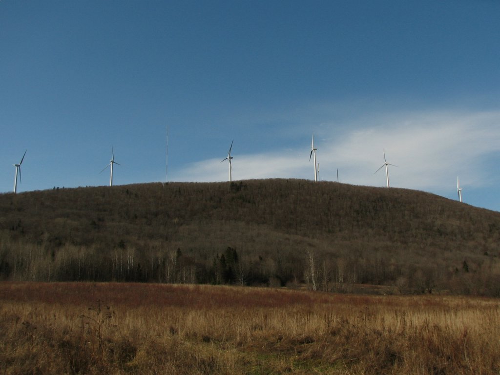
    Just look at that ugly clean air!

    This photo links from The Thing of the Moment, where there are many excellent photos of Mars Hill and other Maine places.


    A pretty good article in today's Press Herald reported on locals' reactions to the Mars Hill wind power project, scheduled to start generating electricity this month.

    Althouth the article's headlines in the front page of the printed edition make much of a supposed "controversy" over an "eyesore," the text of the article only reveals a few objections, which come off sounding relatively petty.

    The Bangor Daily News, in its reports, has focused more on the town's tax benefits. Since Bangor's newspaper is a lot closer, geographically and politically, to Mars Hill, I'm inclined to believe that there's really less controversy than the Portland paper's headlines warrant.

    Still, the Press Herald article brings up the point that the Mars Hill windmills will be a test case for other wind power proposals pending elsewhere in the state. One of those proposals, for Redington Mountain, does face some more serious opposition, due to its proximity to the Appalachian Trail. The Maine Appalachian Trail Club, Audubon Society, and Appalachian Mountain Club have all expressed their opposition to that proposal, not only because of visual impacts, but also because of the project's potential impacts to alpine zone habitats.

    Considering that global warming is a certain way to eliminate all alpine habitats from the state within the next fifty years, these objections, while they have some merit, amount to an attempt to rearrange deck chairs on the Titanic.

    Links to other wind-power projects and news:

  • Redington Mountain
  • A compromise proposal for Redington
  • A three-turbine proposal in Freedom, east of Waterville
  • Cape Wind, an offshore project near Cape Cod.
  •