Tuesday, September 18, 2012

How an Icon of Journalism Became a Hollowed-Out Billboard

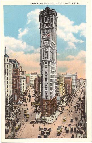
When it was built at the southern end of Longacre Square in 1903, the new headquarters of the New York Times became a landmark of midtown Manhattan, and helped publisher Adolph Ochs convince the city to rename the famous intersection in front of the building as Times Square.

One Times Square in 1904 (source).One Times Square in 2010.
Photo: Bernt Rostad/Flickr
By the mid-20th century, though, the Times had sold the building, and a new owner dismantled the intricate granite and terra-cotta facade to replace the exterior walls with plain concrete panels. In 1996, shortly after the City Council passed new laws that expelled porn theaters from the area, the building got sold again, to Sherwood Outdoor, an advertising firm. By then, the building's signage was covering most of the exterior windows, leaving the offices inside rather dark and dreary.

Rather than spend money to renovate, the new owners decided to simply abandon the building's interior above the 3rd floor, and use the top part of the building exclusively as a billboard (the lower 3 floors are still used, periodically, as retail space — it's currently a Walgreens drug store).

So for the past 15 years, the iconic building that was the namesake of Times Square itself, and a major headquarters of journalism, has become a hollowed-out shell, a mere scaffold for electronic signs.

At the Crossroads of the World, the value of advertising has trumped the value of journalism, and of work in general. 


Postscript: Illustrator Joe Mckendry has made a gorgeous before-and-after elevation drawing of the building's eastern facade in 1904 and in 2010, for his book One Times Square.

Monday, September 10, 2012

The Indian Burial Ground in the Basement

I was walking the dog this weekend along Hammond Street, a quiet residential block squeezed on the hillside between busy Washington Avenue and the industrial district of lower East Bayside here in Portland. They're building two new apartment buildings on a lot at the end of the street, and have started digging out the foundations.

Fascinatingly, the basement excavation has revealed a cross-section of the hillside, which is full of shells. Mostly longneck clams, with a few oysters here and there:


The dense layers of shells are sandwiched between clayey marine soils that are typical of our neighborhood, and they follow the slope of the hillside, such that the same layers are visible twice in the excavation: once against the vertical wall on the uphill side, and once again on the floor:


I'm pretty confident that this is a Native American shell midden — a trash heap from seafood feasts of centuries past. Though it's several blocks and a freeway crossing away from the ocean today, this hillside used to drop straight down into the tidal flats of Back Cove, as you can see in this 1837 map of Portland. The red dot shows the site of this construction site, smack dab on the old shoreline:


Back Cove is a tidal basin — exactly the kind of place where longneck clams thrive, although you wouldn't want to eat them these days. Other parts of the shore around Back Cove were probably marshy and difficult to access from land, but this location, next to a steep hillside, probably offered more direct access to the flats for humans, and for clams, there was relative proximity to the nutrient-rich tidal flows at the Cove's outlet.

I've been kind of stumped by how the shell heaps are interspersed with layers of clayey soil. This photo shows the horizontal cross-section of two layers (on the future basement floor in the foreground) as well as the sloping vertical cross-section (on the street-facing wall, in the center of the photo). At the left edge of the photo is Anderson Street, which was once the shoreline. How did all that clay get in between? 


Stranger still is how some of the shell layers seem to overlap with each other:


My guess is that the steep slopes of the hillside probably set off occasional landslides, which would periodically bury a heap of shells under a thick layer of mud washed down from the higher ground above.

Any archaeologists care to comment?

Related post: Longfellow's Garbage

Update: Howard Reiche e-mailed me this this morning (Sept. 11):
The Knudsen home, which
stood on the site until this
summer. From the City of
Portland's 1924 tax records
.
 Good for you. That was my grandfather’s (Knud Knudsen) house where he raised 13 children after immigrating from Denmark. We have a family photo of my mother, Laura Christine (Knudsen) Reiche, feeding the ducks in the water which came to the foot of their garden which I walked in many times..
    Hammond St. was named after the Hammond rope walk which was originally at that site. Possibly the “layers of clay” mystery had something to do with the construction or changing of the rope walk.