Showing posts with label Pavement pollution. Show all posts

Monday, April 04, 2011

The Utopia Over the Freeway

The Bridge Apartments in Washington Heights. Photo used by permission from photographer Mario Burger,
Burger International, Inc.
.

Last fall, the Cooper Union hosted a show dedicated to Paul Rudolph's Lower Manhattan Expressway (or LOMEX) proposal - a design study intended to enamor New York City's modernist architectural elites with Robert Moses's freeway-building ambitions.

Rudolph was a genius draftsman, and he produced stunning drawings that manage to generate a sense of futuristic optimism and excitement around the idea of living above thousands of exhaust pipes stuck in traffic:


One of Paul Rudolph's LOMEX studies.


From at least the 1930s, when Moses was in charge of the Parks Department, New York's "Master Builder" wanted to build a freeway through lower Manhattan, connecting New Jersey to Brooklyn by way of the Holland Tunnel and the Williamsburg and Manhattan Bridges. Interestingly, Paul Rudolph's proposal came only during the Lower Manhattan Expressway's dying days, and only at the sponsorship of the Ford Foundation.*


Jane Jacobs had published The Death and Life of Great American Cities seven years previously, in 1961; a year after Rudolph began his study of the Expressway, in 1968, Governor Rockefeller would freeze Moses out of the city's transportation agencies. By the time Rudolph stopped working on this proposal in 1972, the city was on the verge of bankruptcy and grand building schemes like this one were relegated to the realm of fantasy. In a review on the Design Observer blogs, Mark Lamster wrote that Rudolph's was "an extraordinary vision, if not a practical one."


Rudolph's drawings are indeed amazing, especially the ones that compare the hugeness of his vision to existing landmarks (the red drawing above frames the towers of the Williamsburg Bridge, which is huge in its own right, in the center).

The show is powerful not just for its audacity, but for what we know now, forty years later, when the historic neighborhoods that Rudolph and Moses would have liked to have bulldozed are worth hundreds of billions of dollars. In hindsight, it's easy for us to say, "something like that could never actually happen."

Except for one thing: something like Rudolph's vision actually did happen. A few miles away, on the same island of Manhattan, urban renewalists and highway builders had actually finished a massive cross-island expressway, topped with apartment towers and a major transit hub, several years before Paul Rudolph started designing the LOMEX.


The new Trans-Manhattan Expressway seen from a tower of the George Washington Bridge. Photo from the LIFE Magazine archives.


This is the Trans-Manhattan Expressway, also known as I-95, the only Interstate highway that crosses Manhattan Island. It was opened in 1963, when a second deck was added to the George Washington Bridge to New Jersey. It crosses the island in Washington Heights, where the island is only one mile wide, but its construction still required the demolition and clearance of dozens of buildings on eight dense city blocks.
When the Expressway opened in 1963, Robert Moses, the freeway's champion, foreshadowed Paul Rudolph's work to come later in the decade:

"This is the first expressway to be built across Manhattan, and we hope that the Lower Manhattan and Mid-Manhattan expressways, both of which have been the victims of inordinate and inexcusable delays caused by intemperate opposition and consequent official hesitation, will follow. These crosstown facilities are indispensable to be effectiveness of the entire metropolitan arterial objective of removing traffic through congested city streets."

Of course, the scorn for opposition that Moses has on display in this quote was even then sowing the seeds of his downfall. And with the benefit of hindsight, it's easy for us to chuckle at the notion that building a fast and convenient route for cars and trucks to enter Manhattan would do anything to remove any traffic from New York's streets:

Photo by Zach K.


The Trans-Manhattan Expressway wasn't merely a freeway, though. It was a linear megastructure that stacked a complex of modernist transportation hubs and huge apartment blocks overhead. On the western end, Moses built a winged bus terminal that squatted over the freeway's entrance ramps:

Looking west towards New Jersey over the new Trans-Manhattan Expressway and the George Washington Bridge bus terminal. Photo courtesy of the Port Authority of NY-NJ.


George Washington Bridge bus terminal. Photo by gezellig-girl.com.


On the eastern end, the city sold development rights to private developers who built four enormous apartment towers, known today as the "Bridge Apartments." The New York Times did a story a few years ago called "Life on the Road," a chronicle of the apartments' history and what it's like to live there. "If the windows are open, the noise is most deafening on the middle floors, and people inside find that they need to raise their voices to hold a conversation or talk on the phone," writes reporter David Chen. "The winds carry vehicle exhaust upward, which is especially noticeable on the terraces. And on most floors, the vibrations of trucks can clearly be felt, along with those of any construction equipment."


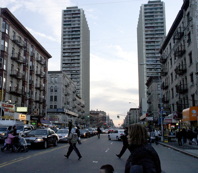
Two of the four Bridge Apartment towers, which mark the path of the Trans-Manhattan Expressway beneath. Photo by Zach K.


The Bridge Apartments loom over Washington Heights like mother ships from a sci-fi movie. I remember catching sight of them from time to time when I worked as a park ranger in Inwood Hill Park, two miles away, and being startled by their incongruous appearance on the skyline. This in a city known for its tall buildings - but the four towers, lined up in a row and hulking over a major freeway, have an otherworldly quality to them (Mario Burger's photo at the top of this post is the best illustration of this feeling that I was able to find online).

In all the reviews I've seen of Rudolph's show, I'm surprised no one has mentioned the Trans-Manhattan Expressway. It was obviously a major precedent in Rudolph's mind and in his designs - when he began working on LOMEX, the Trans-Manhattan Expressway would have still felt new and futuristic, not yet dated and dingy with soot and exhaust as it is now.

And for those modernist romantics who wonder at the ambitions of people like Robert Moses and Paul Rudolph, and yearn for a future that might have been: the gritty reality is on plain view to all in Washington Heights.


*The Ford Foundation's involvement in promoting LOMEX was probably not a self-serving effort to get more New Yorkers into Fords, as I'd initially suspected. By the late 1960s, the Ford Foundation, most famous for sponsoring the Corporation for Public Broadcasting, was separating itself from the Ford Motor Company through stock divestiture and new members of its Board of Directors (source). Instead, the Foundation seems to have hired Rudolph in a well-meaning - if misguided - effort to promote "urban renewal" in what were then some of the city's most impoverished neighborhoods.

Friday, March 05, 2010

The working parking waterfront

Kudos to reporter Tom Bell for bringing attention to the over-supply of cheap parking - on waterfront property, no less, in today's Portland Press Herald. Bell notes that "Until the middle of the last century, when Portland's waterfront was a hub of transportation and fishing activity, the piers were covered with buildings, including warehouses for grain, molasses, coal and wood."

This was the city's working waterfront heritage, which everyone wants to preserve and protect.

However, Bell goes on to observe that "Most of those buildings have been demolished over the years, and today more than three-fourths of the area that could be developed in the central waterfront zone has no buildings. Instead, there is plenty of parking."

It's got some choice quotes, including:
“We don’t have a working waterfront. We have a parking waterfront,” said Don Perkins of the Gulf of Maine Research Institute.
This is kind of a dangerous idea. Portland prides itself so much on its working waterfront - the handful of bait shacks, trawler berths, and chandleries that still remain on the city's piers. Speaking the truth - that 3/4 of the "working" waterfront is really just a big parking lot - really deflates this big source of the city's pride.

Even the hotel and convention business, which is traditionally been seen as a prime economic adversary of marine industrial uses on the city's piers, agree that the acres of empty lots are a blight on the waterfront:

More public transit is the key to eliminating parking lots on the waterfront, said Barbara Whitten, executive director of the Convention and Visitors Bureau of Greater Portland. "A sea of cars," she said, "is not an attractive way to market the waterfront."

Read the full article here.

Thursday, October 01, 2009

The Future Portland, Oregon, as Envisioned by Robert Moses

The other Portland's weekly Mercury published a great article last week about that city's planned-but-unbuilt freeways. The west-coast Portland is very much in love with itself in general, but the fact that it had the foresight in the 1970s to reject millions of dollars in freeway funds, and re-appropriate the money for the first line in its growing light rail network, is something that it should legitimately be proud of. In the decades since, a number of conventional-wisdom-bucking decisions like this one have made the city what it is today, a leader in urban planning and design.

Before the city abandoned its plans for the Mount Hood Freeway or tore out its waterfront Harbor Drive expressway, though, it was gleefully subscribing to the same happy-motoring, urban-renewal fads that poisoned so many other American cities in the second half of the twentieth century. During World War II, the city commissioned an infrastructure plan from Robert Moses, the same "master builder" who bulldozed hundreds of New York City blocks in order to build new freeways to the suburbs of Connecticut and Long Island.

In a follow-up blog post, Mercury writers posted a PDF copy of the Moses report, which calls for an inner-city loop of grade-separated freeways around Portland's downtown. This loop actually did get built in a slightly modified form, as Interstates 5 and 405.

It's striking to see how the city developed in the neighborhoods where actual freeway construction deviated from Moses's plans. Moses's proposal for an East Side freeway probably would be more appealing to Portlanders than what actually got built: while Moses suggested a route through the industrial neighborhood a few blocks away from the river, the city built the freeway right on the Willamette's eastern bank instead.

Moses also proposed a "Foothill Thruway" that would hug the base of Portland's West Hills, through the neighborhoods of Goose Hollow and cutting diagonally through the city's tony NW 23rd Avenue neighborhood. Here's an illustration from the report:

The caption is vague, but by reading the report's description of the proposed route ("a crossing of Burnside Street near the intersection of King Street... crossing Jefferson Street between Eighteenth and Nineteenth Avenues") and looking at maps, this seems to be a westward-looking view of the Goose Hollow neighborhood. I think that the stadium visible at the lower edge of this drawing is today's PGE Park, next door to the Multnomah Athletic Club, a country-clubbish place where I worked through college as a lifeguard. Here's what the neighborhood looks like today:

High-rise condos and apartment buildings occupy the land that Moses had envisioned for freeway on-ramps, and the neighborhoods of Northwest Portland that would have been bulldozed now host some of the city's most valuable retail and residential properties.

Not to say that the city avoided the destruction altogether; the foothills freeway became I-405, which required the demolition and excavation of about 50 city blocks along the western edge of downtown in the mid-1960s.

In a failed bid for the 1968 Olympics, city boosters/saboteurs published a much more ambitious freeway-development plan, which included the infamous Mount Hood Freeway and many others. Oregon's Cafe Unknown blog has a history of the Olympic bid and a few images from the city's Olympic plans, which mostly consist of suburban stadia surrounded by huge parking lots. A map of the ambitious plans for the freeway network is about 2/3rds of the way down the post.

Moses's report was published in 1943, about a decade before the freeway construction binge caused by Eisenhower's interstate highway development bill. In addition to the freeway plans, Moses included a lot more mundane and uncontroversial advice for improving parks, playgrounds, and sewers.

Still, as commenter "atomic" notes in the Mercury's blog post, it's "strange to think that something so apocalyptic was going on in Europe and Asia, and dudes over here were planning how we were going to manage traffic jams when we were done with it."

Wednesday, January 14, 2009

Cheonggyecheon


Cheonggyecheon is a small stream that once flowed from a cirque of mountains that surround the historic center of Seoul into the Han River, 6 kilometers away.

In the years immediately following the Korean War, Cheonggyecheon was overrun by informal refugee camps, shantytowns, and sewage. The stream was soon paved over for a wide boulevard; in 1968, during Korea's own urban renewal fad, an elevated highway was stacked above the road. In spite of its historic and cultural significance to Korea, Cheonggyecheon spent over half a century in an underground culvert, choked with filth.

Then, in 2003, in an act of political will that seems miraculous to me, Seoul mayor Lee Myung-bak began a project to remove 16 lanes of stacked expressway and restore the lost stream beneath. Two years later, a vibrant, wild park had replaced a traffic-choked freeway. Believe it or not, the two photos above show the same section of stream (the two buildings in the center-right of the top photo, taken sometime early in the 2000s, are the same two buildings on the left side of the bottom photo).

Tearing out a huge downtown freeway didn't create mass gridlock, as the project's opponents had promised: traffic actually moves faster and more smoothly today than it did when the freeway was there. In an interview with the Guardian two years ago, Kee Yeon Hwang, a professor of urban planning, said that "as soon as we destroyed the road, the cars just disappeared and drivers changed their habits. A lot of people just gave up their cars. Others found a different way of driving. In some cases, they kept using their cars but changed their routes." In other words, people aren't as stupid as traffic engineers think they are. Koreans gave the project a definitive seal of approval when they gave Lee Myung-bak, the project's primary political champion, a promotion to the presidency in 2007.


By replacing idling cars with a naturalized waterway, Seoul also lowered summer temperatures in the center of the city and improved air quality and circulation. The Cheonggyecheon isn't yet a functioning watershed: the water flowing from the "headwaters" in the center of Seoul is currently being pumped uphill from the Han, instead of trickling down from the mountains. But it's still attracting wildlife, including fish and herons, and there are more plans in the works to restore elements of the stream's natural hydrology.

Of all the parts of the park I've looked at, this one's my favorite: three remnant highway abutments standing in the middle of the stream like a utopian apocalypse scene - a glimmer of hope that the brutal regime of freeways and highway engineering is losing its grip on the world's cities. Credit for the photo goes to Flickr user Ben Harris-Roxas:

Tuesday, September 02, 2008

Portland Combined Sewer Overflow Outlets

Labor Day's come and gone, which means that there are scant opportunities left to enjoy Maine's beaches. The ocean's temperature is at its warmest this time of year, and a stretch of dry weather means that Portland's combined sewers haven't overflowed into Casco Bay since mid-August.

But if we do get any wet weather, you might want to avoid swimming near any of the markers on the map below. These are Portland's combined sewer overflow outlets, where a toxic combination of street runoff and raw sewerage overflow into local watersheds during wet weather (read all the details here):


View Larger Map

Circles on the map are outlets that continue to function as combined CSOs (mixed sewage and street runoff); stars are outlets that only dump street runoff (which is bad enough, but at least the amount of feces in it is limited to that produced by the population of city dogs with irresponsible owners).

Thursday, June 05, 2008

Proposal

Storm drain stencils: a neat idea to get people thinking about how city sewers and storm drains actually work. Here's one in South Portland, Maine:


But how about some alternative messages?


Or, more to the point:

[idea inspired by Pruned]

Wednesday, January 23, 2008

Bollevarts and Urban Renewal

I'm currently reading A Clearing in the Distance by Witold Rybczynski, a biography of Frederick Law Olmsted. This is an enjoyable book for several reasons: it follows Olmsted through the history of nineteenth century America as it happens, from Olmsted's reporting on slavery in the antebellum South to his Civil War volunteerism to his gold mine management in wild west California to the establishment of his landscape architecture firm. Along the way, Olmsted's various careers and interests also reflect America's changing and emergent attitudes about conservation and wilderness, especially in cities.

Anyhow, I just learned from this book that "The first leisure promenades in European cities were on top of abandoned city fortifications. These promenades came to be known as bollevarts, or boulevards, after the German bollwerk (bulwark)."

Now, we don't really have abandoned fortifications on which to build new public spaces here in America. But there is a growing trend of tearing down ugly downtown freeways to replace them with new parks and other walkable, humane public spaces. New York demoted its West Side Highway, and San Francisco removed the rubble permanently when the Loma Preita earthquake rendered the Embarcadero Freeway as useless and dangerous to cars as it had been for pedestrians. As a matter of fact, some people think that we ought to do something similar in my hometown of Portland, Maine.

60s-era freeways are kind of the opposite of medieval fortifications: instead of protecting the cities they encircle, they wage war against them with an assault of murderous vehicles, pollution, noise, and isolation. It's a credit to civilization in general that these aggressive structures are eventually abandoned and transformed.

But if European "boulevards" are an appropriation of Germany's bellicose "bollwerks", what should Americans call their reclaimed freeways? Cabrini Greens, perhaps? The parting of the Moses Seas? How about De-Detroits?

Wednesday, May 30, 2007

They bulldozed it.


Above: Franklin and Oxford Streets in the 1950s. The other historic photo (below) shows another stretch of the long-lost Franklin Street (historic photographs courtesy of Maine Memory Network)
This photograph here is what the corner of Franklin and Oxford Streets looked like about 50 years ago, before the WASPs on the City Council noticed the Irish name on the corner store, called it a "slum," and bulldozed it all to create the hated Franklin Arterial.

Below, another photograph from the same site of another spot on the former Franklin Street. It's hard to know exactly where, since the buildings, shady elm trees, and even the sidewalks have been gone for decades. For those readers who have never been to Portland, here's what urban renewal gave us instead: a grass median full of garbage, some scrubby trees growing over the old neighborhood's rubble, and four lanes of traffic unencumbered by crosswalks or sidewalks. Here's a photo (the Franklin Towers, Portland's tallest building and a fine example of Soviet Sentimental architecture, commands a fine view of the no-man's-land):


Note how all of these "slum dwellings" in the old photos bear striking resemblance to historic homes that now sell for over $1 million in surrounding neighborhoods. Way to invest in real estate, you jingoist highway-engineering dipshits.

Here's some good news, though: my new buddy Patrick writes about schemes to repair past urban renewal idiocy with a new Franklin Boulevard in the Bollard this week: read about it here. Tomorrow at the Franklin Towers will be a "revisioning workshop" to brainstorm new ideas for the blighted pavement - perhaps I'll see you there. Finally, here's a previous post about fixing Franklin Arterial.

Thursday, May 10, 2007

This Is Broken: Tukey's Bridge (of Doom)

Tukey's Bridge crosses Portland's Back Bay between the Munjoy Hill neighborhood and East Deering. It also completes the circuit of Portland's very popular Back Bay running path and links into the Eastern Prom bike path. In short, it is an important and well-used connection in Portland's bike and pedestrian network.

It is also completely and utterly broken: poorly designed and maintained, inconvenient, and unsafe. The fact that so many people still use it nevertheless testifies to its importance as a connector between neighborhoods.

Here's a tour of the bridge from a pedestrian's and cyclist's perspective:

To get to the sidewalk from the south, one must either take the Back Bay path or, if you're coming from any of the neighborhoods on the north side of the bridge, cut through a parking lot and follow a dark, narrow path under an overpass (broken glass abounds, natch).

The bridge makes room for eight lanes of freeway and one meager sidewalk, which is only on one side of the bridge. For most of its length, the sidewalk only has enough room for two people walking abreast. Bicyclists, runners, walkers, and strollers passing each other in both directions are frequently forced to jockey for space: in traffic engineering terms, this sidewalk's level of service gets an "F".

A big part of the problem is the fact that there's no sidewalk for northbound traffic on the other side of the bridge. Cyclists headed north have the choice of breaking one of two laws: either ride (illegally) on the sidewalk that leads into the bridge from Washington Avenue, or stay on the right shoulder of the road, even for the 100 yards over the bridge where it's designated a freeway and bicycles are forbidden (I opt for the latter option, which is faster and safer to my mind).

Anyhow, continuing southward, bikes and pedestrians have a choice between peeling off onto the Back Bay/Eastern Prom trails or continuing on a narrower sidewalk along the off-ramp to Washington Avenue and the Munjoy Hill neighborhood. If you should choose the latter, you'll encounter this off-ramp to Anderson Street:

Note the beefy guardrails. Traffic here is only supposed to be traveling at neighborhood speeds at this point, but this road is obviously designed to encourage much faster traffic. Not that this could be at all related to the speeding pickup truck that hit me, dragged me along the pavement, and ran away just a few blocks down this same street (see previous post).


Because of the guardrails, bikes and pedestrians must cross the off-ramp at the crosswalk, which at least has a bright sign to get the attention of the hurtling traffic.


Once across the off-ramp, bicyclists have two unsavory choices: either continue up the extremely narrow and overgrown sidewalk, as this guy does, until the guardrail ends and you can hop onto the street.

Or, if you want to be legal, wait until the coast is clear...


At the other side of the crosswalk, make a sharp turn against traffic (keeping a sharp lookout to make sure there aren't any cars coming around the bend at 60 MPH)...


Make a tight turn around the end of the guardrail...


...and ride normally up the right side of Washington Avenue (presuming you haven't been vehicularly manslaughtered in the meantime).


The state DOT could easily and cheaply fix the latter hazard by cutting the guardrail at the other end of the crosswalk and installing a curb cut there where bikes can go directly from the sidewalk to the road. This would also make it easier for northbound cyclists to get onto the bridge path from the other side of Washington.

It's kind of a wonder our highway engineers didn't do this in the first place, but I've seen enough highway engineers to know that they aren't fond of using their legs.

I'll be sending this assessment to the following bureaucrats, and I'd encourage you to send your thoughts on this crossing to the same people:

Tuesday, February 13, 2007

The Turnpike of the future

Today, the state legislature began hearing public comments on the Maine Turnpike Authority's request to widen Interstate 95 in the greater Portland area. As I have said in a previous post, this would be a perfect opportunity to install a regional system of commuter bus and rail services. The Turnpike Authority is flush with cash from its tolls, and it's also responsible for traffic nightmares in communities near Turnpike exits: here's its chance to atone.

Frustratingly, although this is clearly a Portland-area project, the early decisions are being made in Augusta, where the legislature must authorize the Turnpike Authority's plans. A representative from the Authority did visit the City Council a while ago, but City Councilor David Marshall reports that "the presentation made it clear that alternative modes of transportation will not be considered until the end of the planning process. At that
point in the process the deal is basically done." This stone-age way of doing things is clearly illegal (see the Sensible Transportation Policy Act), but it looks as though the Turnpike Authority (which might consider changing its name to The Museum of Eisenhower-Era Transportation Policy) will need plenty of reminding.

For now, we can remind our legislators that they have authority over the Authority. Any planning for the Turnpike should consider a range bus and train alternatives, and when considering widening, the Authority should also be forced to examine the consequences of increased traffic on surrounding communities (like Gray, where Turnpike traffic literally reduced the village center to a slum). Here's the letter I wrote to the Transportation Committee (Senator Dennis Damon and Rep. Boyd Marley, chairs):


Re: Authorization of the Turnpike Authority's Capital Program (widening between Scarborough and Falmouth)

To the Joint Standing Committee on Transportation:

A contemporary saw about highway planning states that "trying to solve traffic by building more roads is like trying to cure obesity by loosening your belt." Increasingly, planners from all disciplines are appreciating the costly futility of building new roads in a sprawling landscape.

Given the increasing expense - public and private - of our state's auto-centric transportation policies, the Legislature should include strong stipulations that the next Turnpike construction project, planned between Scarborough and Falmouth, will substantially diversify our region's portfolio of transportation alternatives.

First, and most importantly, the Legislature should require that the Turnpike Authority base its planning on the efficient movement of people and freight - not just vehicles - throughout the Turnpike corridor and surrounding communities.

By the National Environmental Policy Act (NEPA), the Turnpike Authority will be required to examine a range of alternatives in the widening project. In accordance with the Maine Sensible Transportation Policy Act, the Legislature should stipulate that EVERY alternative under consideration (besides the required "no action" alternative) include some combination of regional rail investments, expanded and new commuter bus (ZOOM) services, HOV and HOT lanes, and bike/pedestrian trails.

NEPA also requires that federally-funded projects examine "cumulative effects," i.e., effects beyond the immediate scope of any project. In this case, the Legislature should make clear that the Turnpike Authority must weigh alternatives according to their effects on nearby arterials and town centers. Local and state agencies should not bear additional costs or congestion as a result of the Authority's actions.

I will close by reminding you that automotive costs are beginning to rival housing expenditures among Maine households, and that traffic on the Turnpike alone generates more air pollution than all of the state's power plants combined. Please encourage the Turnpike Authority to make 21st-century investments in true mobility, rather than another 20th-century road
widening.

Yours sincerely,


Christian McNeil

Tuesday, January 23, 2007

Oil slick marsh

If you ever find yourself in dire need of some carcinogenic soil or a bunch of dirty styrofoam cups, keep this place in mind. This small wetland is wedged between a new connector road to I-295 and two large parking lots at the edge of the Plank (aka the Libbytown neighborhood). It seems likely that it was once an inlet to the Fore River estuary before development on Thompson's Point isolated it here.


Gasoline rainbows and a baffling chain-link fence in the middle of the water are symptoms of this wetland's biggest problems: it's surrounded by oil-drenched pavement, and it's on the fringes of property lines and anyone's sense of stewardship. Ironically, most of the polluted runoff comes from the parking lot of 50 Sewall Street, Portland's first certified green office building (its "for lease" sign, advertising not to critters in the water but to drivers on the out-of-sight highway, is visible in the upper left corner of the photo). An inch of rain falling on the adjacent 2-acre parking lot produces more than 54,000 gallons of stormwater, which washes a lot of garbage and petrochemicals on the pavement into this wetland.

Because this space is literally marginalized, at the edge of and several feet lower than the streets and parking lots that surround it, few people are aware of the pollution that affects it - which means that even fewer are willing to do anything about it. And just to kick it while its down, someone added a pointless chain link fence. The fence straddles a natural moat in between two steep embankments, but I suppose that someone wanted to be absolutely positive that no one would walk from the easily accessible public parking lot on one side to the easily accessible public road on the other side. Of course, the very occasional vagrant blogger is able to scale the fence without much difficulty, but whatever.

In spite of all the concrete encroachments, the polluted runoff from acres of surrounding parking lots, a worthless fence, and the noise and exhaust from the bus station next door, this is actually a pleasant, quiet place. When I walked down to take a closer look at it, I even surprised a muskrat in the water. I encourage more people to visit, especially the tenants of the "green" building next door. If we can make this place less marginal, we can make it less polluted as well.

Wednesday, January 10, 2007

The Sensible Transportation Policy Act

Did you know that Maine's Department of Transportation and the Turnpike Authority are required by law to "reduce the State's reliance of foreign oil and promote... energy-efficient forms of transportation"? And that they must give "preference to... other transportation modes before increasing highway capacity through road building activities"?

The Sensible Transportation Policy Act, passed in 1991, says all of this and more. It's a brilliantly progressive law. Too bad our transportation planners habitually break it.

After sixteen years of "sensible transportation," Maine has more roads, more freeway lanes, more traffic, and more pollutants from incinerated foreign oil, but state investments in bike/ped facilities and transit are virtually unchanged (i.e., virtually zero). Sure, we've got a train to Boston and a few scattered bike paths. But compare those investments (wildly successful in spite of their small scale) to the expenditures on new roads. We'll spend $50 million on the Gorham Bypass alone, even though it's going to generate more traffic and congestion in Standish and Westbrook, while energy-efficient, foreign-oil-independent sidewalks and bike routes scrape by with $750,000 a year.

The Maine Turnpike Authority is now looking to widen their freeway to six lanes through the Portland area. So far, environmental groups across the state are letting this one go without so much as a whimper (most of their leaders drive the same road, after all). But the Turnpike Authority is fabulously rich with toll revenues. What if we actually enforced the Sensible Transportation Policy Act, and told the Authority that they may only widen I-95 if they provide regional commuter bus service? Or a bike/pedestrian path running parallel to the freeway to connect the Maine Mall area to Portland, Westbrook, and West Falmouth?

Transit and bike/ped amenities like these would barely dent the Turnpike's budget, and they'd also provide fabulous enhancements to regional mobility. Instead of serving suburban commuters and weekend vacationers, the Turnpike could serve more of the people who actually live in greater Portland. There are already rumblings of these demands from local bike and pedestrian advocacy groups in Portland. The bigger environmental organizations may not yet be on our side, but at least the law is.

Photo: the riverfront bike path in Hoboken, New Jersey.
Budget figures from PACTS Destination Tomorrow plan

Saturday, December 16, 2006

The Plank

This is the neighborhood of Portland where Congress Street crosses under the freeway. According to the city, the neighborhood is "Libbytown," but I call it "the Plank" because of the hazards involved in walking it.

This picture is taken from Congress in front of the bus and train station, looking toward downtown. Suppose that you're a hapless pedestrian who's recently arrived by train in the Forest City. Downtown is only a twenty minute walk away. But first, you'll have to traverse the Plank's dozens of acres of on ramps, which the Department of Transportation (motto: "Death to Pedestrians!") has thoughtfully designed to punish anyone who doesn't use a car all the time.

The photo shows the first of four freeway-style crosswalks that an eastbound walker must navigate. Cross the first lane of turning (but not stopping) traffic to gain the relative safety of a tiny traffic island, where you will be surrounded on three sides by rushing traffic. After that, there's a four-lane crossing and another island, then a hop across another turn lane, then a dark underpass, two more freeway ramps, and that's the Plank.

At the other side, treat your injuries at Maine Medical Center, only six more blocks ahead (ambulances pass through the Plank frequently, and if you're lucky, that's the kind of vehicle that will hit you).

The Plank is even more staggering when seen from above: here's the link to the Google satellite image. The Plank is in the middle of a central-city neighborhood: dense residential neighborhoods to the east and north, a growing cluster of medical offices to the west, the future site of Mercy Hospital to the south. The dozens of empty acres that its loopy ramps occupy are probably worth millions of dollars, and it could be a thriving employment district, the home to hundreds of offices and homes within walking distance of hospitals and the train station. Instead, it's a barrier that forces everyone in those surrounding neighborhoods to get into their cars in order to get to the other side. The Plank exists to move traffic, but by taking up so much space, it creates a lot of traffic, too.

What were those traffic engineers thinking when they built this thing? I'd like to hear from them - perhaps on a rush-hour walking tour of their creation. Let's go, traffic engineers. Get into that crosswalk you designed. I'll be right behind you.

Tuesday, December 12, 2006

No such thing as free parking


The image above is a satellite image of downtown Portland, with surface parking lots (solid red) and parking garages (shaded red). Congress Street runs diagonally through the picture. This does not include on-street parking or parking garages that occupy the first level of larger office buildings (like One City Center).

Consider these quick facts:

  • The construction cost of one parking spot in an above-ground garage is $20,000. The land cost for one surface parking spot is about $2,500.
  • The City of Portland provides hundreds of acres of rent-free real estate for automobile storage on its streets. Many of the city's homeless live in cars, because Portland has reserved much more of its land and money for free parking than for affordable housing.
  • Portland taxpayers, businesses, and consumers pay the true costs of parking. Commuters from Standish, Windham, and other outlying communities generally don't pay for them, even though they use the majority of parking infrastructure.
  • It needs further research, but it's my educated guess that subsidies for free parking exceed subsidies for affordable housing by one or two orders of magnitude.

    It comes down to this: like almost every city in the nation, Portland has Socialized Parking. Every developer who wants to do business in the city has to meet Stakhanovite parking production quotas. From each taxpayer according to his means, to each motorist according to his auto-addiction.

    Click the link above to learn more about the book The High Cost of Free Parking, by Donald Shoup.
  •