Showing posts with label transportation. Show all posts

Thursday, April 03, 2014

Watch Charles and Ray Eames pitch Eero Saarinen's "Mobile Lounges"

Jess and I took a vacation to the Grand Canyon last week, which was fantastic — but as spectacular as it the thing that actually inspired me to post on this neglected blog was a bleak bit of airport architecture we encountered on our way home.

Our flight got diverted through Washington D.C.'s Dulles airport, and on the way through we were herded into one of these bizarre vehicles (which you might recognize if you've been there yourself) for a ride to the next terminal. They kind of resemble an open-plan double-wide trailer stacked atop a tank chassis:
(image from Wikimedia Commons)


Being in Washington, my initial guess was that these were the unwieldy product of some pork-barrel military industrial contract. But I was mistaken — these weird buggies are actually the vestigial remnants from an unfulfilled future of jet travel.

In 1958, the architect Eero Saarinen was commissioned to design Dulles, which would be one of the first major airports built from scratch to serve jet aircraft. Foreseeing the long walks and sprawling terminals of our modern era, Saarinen suggested that it would be better to employ a kind of satellite parking system for planes, with passengers shuttled from a compact, comfortable terminal onto the tarmac via these mobile boarding platforms, which he called "mobile lounges".

I could go into more detail about the details and rationale behind this idea, but luckily for us Saarinen commissioned this wonderful short film from his friends Charles and Ray Eames as part of his campaign to sell the authorities on his design, so I'll just let them explain it:


Untitled from CHRISTINA LAETZ on Vimeo.

The mobile lounges are like a horizontally-oriented elevator: a door opens, you walk in, you wait a while, another door opens and you exit somewhere else. Airport travel was more glamorous back then, though: on our short ride between the modern Dulles terminals, the mobile lounge was pretty dingy and crowded — certainly nothing like the luxury buses depicted in the Eames' cartoon.

Saarinen's concept enjoyed a brief popularity in the early 1960s — mobile lounges were also adopted at Montreal's Dorval airport and Charles de Gaulle in Paris — but like the Betamax video player, they were an innovation that never quite caught on.

Wednesday, May 01, 2013

Fossil fuels bike tour

Late last fall, builders wrapped the construction of the new Veterans' Memorial Bridge, which spans the Fore River in the western reaches of Portland harbor. The project included a beautiful new bike path between Portland and South Portland, and this evening I went out to ride it for the first time this spring.


The old bridge (recently dismantled) used to run through the center of the photo above, immediately parallel to the railroad bridge at left. Its former course is now an empty lot with some remnant orange construction fencing. The coastline here is full of concrete riprap and odd tidepools formed from 20th-century construction debris.


Nearby on the Portland side of the bridge is Merrill's marine terminal, which transfers miscellaneous cargoes between ships and the railroad.  There's usually a large pile of coal here, but not much of it remained this afternoon. Maine has no coal-burning power plants, but at least one of its large paper mills still burns coal to fire its boilers.


I dig the interpretive signage.


Calcium carbonate, according to Wikipedia,  is mainly used in construction "as an ingredient of cement or as the starting material for the preparation of builder's lime by burning in a kiln." But these tank cars are more likely headed to one of Maine's paper mills, which are increasingly specializing in value-added coated paper products. Ground calcium carbonate can be used as a filler to substitute for wood fiber, and can also replace kaolin in glossy paper production.

A few years ago, some local philanthropists decided that they needed to beautify the oil tanks with art, and hired a Venezuelan-born artist to design the patterns. I admit I kind of like it, even though I blanch at how much money they spent on it. 


And I'm put off by the a strange impulse to cover the oil tanks in expensive sanctioned art. I'd like to hope that it brings more attention to the oil tanks and makes passing motorists think about their dependence on the global petrochemical industry. But I think most of the wealthy donors are hoping that the paint job will obscure the dirty truth.

On a bike, though, you don't just see the tanks — you smell them, too. A volatile organic bouquet of benzene and sulphates.

A bundle of pipes lead from these tanks to a wharf on the waterfront, where a fuel barge was docked this evening. Similar barges often can be seen refueling tanker ships in the harbor with bunker fuels — the cheapest and filthiest of oil products, so dirty that they generally can only be burned at sea, outside of state and national jurisdictions. A string of oil-containment booms snake out from the wharf's pilings.


For all the fossil fuels on display here, the ability to see them on foot, or on a bike, is a positive development. The new bridge replaces one that had been built in the mid-1950s and designed as a freeway spur. It had one narrow, crumbling sidewalk that dead-ended at a freeway interchange.

Thanks to extensive local activism, the new bridge includes a well-lit bike path, and a lower speed limit and narrower lanes. The freeway interchange on the South Portland side has been  narrowed to a bottleneck where it meets the bridge, in order to force car traffic to yield to bikes and pedestrians.


I like to think how we forced motorists to sacrifice a second or two on their drives across the harbor in order to make the bridge a friendlier place for those of us who prefer not to burn oil. Though I suppose this also means that a few motorists will live longer by not dying in car accidents, only to burn more oil in their old age.

Tuesday, August 28, 2012

The Pizzashed

PBS has commissioned an amazing-looking documentary series called America Revealed (partially based on the popular BBC series "Britain from Above," from which I learned about the Teatime Deluge). In this segment, they attach a GPS device to Dominos Pizza delivery guys in Manhattan to animate the patterns of pizza delivery on a Friday night.

And then the camera zooms out, revealing the routes of the pizza shops' daily deliveries from a distribution center in northern Connecticut.

And then the camera zooms out more, to show the routes of satellite-embedded, refrigerated trucks moving across the continent, bringing dough, toppings, cheese, and tomato sauce from farms and food processing facilities to the distribution centers.

Behold, the American pizzashed:

Watch Pizza Delivery on PBS. See more from America Revealed.

Wednesday, May 09, 2012

Ten thousand public bikes bloom in Manhattan

Later this summer, New York City city will roll out thousands of publicly-owned bikes parked at stations, spaced a few blocks apart across three boroughs, where visitors, workers, and neighborhood residents will be able to borrow a bike for short-term rentals.

Lots of other cities have already pioneered the bikesharing idea (even Houston, Texas managed to implement bikesharing before New York did, with a much smaller 3-station downtown network that opened this spring). With origins in Paris and Montreal, bikesharing has always had a tinge of utopian socialism to it, promoting the shared use of public property over privately-owned vehicles.

But it's a socialist idea that works brilliantly, thanks to mobile technology: users can use their smartphones to locate bikes and a station near their destination, while bikeshare managers can locate lost or broken bikes with GPS, and dynamically track which stations need more bikes due to high demand. Lots of new business startups seek to duplicate the same communistic idea of letting people share their private property (whether spare bedrooms or automobiles) in exchange for small rental payments. Bikesharing makes cycling in cities easier, cheaper, and more fun, resulting in more people riding bikes for short trips in the cities where it's been established.

Private property, it turns out, is a hassle to take care of. But new technology allows people to enjoy the communitarian benefits of shared property thanks to the capitalist accountability of credit card security deposits and rental payments.

New York City's state-owned bicycles wholeheartedly embrace this ironic marriage of utopian environmentalist socialism with hard-nosed capitalism. They've been named "Citi Bikes," after Citibank, which contributed a $41 million for the naming rights.

Wall Street quants riding to work like Maoist factory workers (although even Maoists own their own bikes) will do so astride bikes plastered with the Citibank logo, and pay at stations that prefer MasterCard, another corporate sponsor.

And so here is a photo, via Streetsblog, of three transportation policy wonks (from left: NYC Deputy Mayor Robert Steel, Alta Bikeshare CEO Alison Cohen, NYC DOT Commissioner Janette Sadik-Khan) and three billionaires (Mayor Michael Bloomberg, MasterCard CEO Ajay Banga, and Citigroup CEO Vikram Pandit).

In a few more years, bikesharing stations will be as much a part of our stereotypical vision of the generic urban landscape as newsstands and bus shelters are today.

Wednesday, August 25, 2010

Refugee Camps for the Middle Class

A 100 kilometer traffic jam that's persisted for nine solid days on a highway west of Beijing this week is just another spectacle of the sort we've come to expect out of the growing nation - an epic traffic jam to complement its equally epic public works, skyscrapers, and factories.


Xinhua, a state-run news agency, reports that truck drivers are camped out on the jammed highway, playing cars amongst themselves and forced to buy supplies from opportunistic vendors at inflated prices. Reports printed in this morning's newspapers claimed that some drivers had managed only to move a mile over the course of an entire day on the road's worst stretches, and that the jam could last another month, until a road construction project ends.


All of these mythic reports come closely on the heels of news that China's economy has surpassed Japan's to become the world's second largest. The surreal traffic jam was an emblem of the nation's surreal growth and ambition.

But instead of delivering the promised capitalist paradise, an overdose of machinery and trade creates a sort of homeless gypsy encampment on the road to Beijing.

The news story reminded me of this scene in Week End, when bourgeois French families exercise their "freedom" to leave the city and enjoy the countryside, only to get imprisoned in an interminable traffic jam:


This scene itself was said to be inspired by Julio Cortazar's surrealist short story, "L'Autoroute du Sud," in which a Sunday afternoon traffic jam south of Paris dissolves into a days-long purgatory of survivalism and black market trade. Characters throughout the story are named only by the cars they occupy:
"Surprise would have been the last thing expressed by anyone at the way in which the water and supplies were being obtained. The only thing Taunus could do was manage the pot of money and try to barter as best he could. Ford Mercury and Porsche came every night to peddle their provisions; Taunus and the engineer took charge of distributing them, taking into consideration each person’s health. Incredibly, the old woman in the ID was still alive, lost in a stupor the women were trying to dissipate. The lady in the Beaulieu, who just a few days before had been vomiting and suffering from nausea, had recovered in the cold weather and and was one of those who helped the nun most with her companion, weak still and a little disoriented. The soldier’s wife and the woman from the 203 were minding the children; the travelling salesman, perhaps to distract himself from the fact that the girl in the Dauphine had preferred the engineer, spent hours telling them stories. At night the lives of the group took on a stealthy, more private character; the car doors would open silently to let in or out some shivering silhouette; no-one looked at anyone else, their eyes as blind as their very shadow. Beneath dirty anoraks, with overgrown fingernails, smelling of being confined in stale, old clothes, there was still a degree of happiness here and there."

- translation by Danny Fitzgerald

France's situation in the 1960s was similar to China's today: record-breaking economic growth after the war, greater mobility, and increasing status among the world's great nations. In both 1960s France and contemporary China, the traffic jam is a symbol of modern opportunity and success, but it's also a nervous reminder of the brutal, survivalist lifestyle that both nations had recently left behind. They're refugee camps for the new middle class.


Wednesday, July 21, 2010

Dumpster Pools on Streets Without Cars

Damn, that last post was a real downer. Sorry, everyone. Why don't we beat the heat by taking a dip in a recycled dumpster parked on a car-free Park Avenue in front of Grand Central Station?


This is roughly what Park Avenue near 42nd Street will look like on three consecutive Saturdays in August, when the city invites pedestrian and cyclists to enjoy major streets without any motor vehicle traffic. It has all the trappings of a futuristic Ecotopia, where fashionable pedestrians have re-conquered the highways from automobiles and dumpsters hold swimming pools instead of garbage. Luckily the image above is just a Photoshop job, so that kid diving into the shallow end isn't really going to break his neck.

The dumpster pools are a new addition for the second annual "Summer Streets" event. This massive prohibition of motor vehicle traffic on one of Manhattan's major avenues to is actually an initiative of the city's Department of Transportation under the leadership of Janette Sadik-Kahn, an avid cyclist and pedestrian. Let this be a lesson to all the other Departments of Transportation: while your pencil-necked bureaucrats are making life more difficult for pedestrians and designing expensive new ways for people to waste their time in traffic, New York City is showing us how transportation planners can actually be lovable.

Saturday, April 24, 2010

Safari 7: a wilderness tour of Queens


During a few days spent in New York, I had a chance to briefly visit the Safari 7 Base Camp, set up in Grand Central for Earth Week.

Safari 7 is pretty much exactly what I have been thinking about doing ever since I worked as an Urban Park Ranger a few years ago in Inwood Hill Park: a guided tour that highlights nature and ecology in the places we typically overlook those things. I'm glad that someone actually had the initiative to make it happen. From the project's description:

“The 7 line is a physical, urban transect through New York City's most diverse range of ecosystems. Affectionately called the International Express, the 7 line runs from Manhattan's dense core, under the East River, and through a dispersed mixture of residences and parklands before terminating in downtown Flushing. Safari 7 circulates an ongoing series of podcasts and maps that explore the complexity, biodiversity, conflicts, and potentials of New York City's ecosystems. Tours are available online and can be experienced independently, or in group expeditions and workshops organized by the Safari 7 team.”


The "Base Camp" at Grand Central included an array of gorgeous banners that highlighted things like the aquatic wildlife of the East River, the ecosystems of decomposition at work in the city's huge “cemetery belt,” and the dual role of urban chickens, as food sources and as illegal fighters. The centerpiece of the project is a series of podcasts, short enough to listen to between stops, that describe various ecological phenomena at work at each stop along the line.

Thus, as you ride under the East River, you can listen to a podcast about the tiny island formed from that tunnel's excavation, and learn about the cormorants that nest there. Or hear about the ecology of courtyard gardens in Queens, while you try to get a glimpse of one from the elevated portion of the line.

Over the next few weeks, I plan to write more about those individual podcasts and some of the issues they discuss in more detail. Much of the subject matter isn't unique to Queens - no matter what city or backwoods internet-enabled cabin you live in, there's something for you to learn about your own human habitat. Visit safari7.org to download your own safari audio tour.

Friday, January 29, 2010

Ski Your City!

Last week, most of Maine got a soaking 3 inches of rain, which washed away most of the season's snow. It was a sad day.

But as I write this, an unlikely alliance of scaffolders, public works employees, and snowmaking crews from the Sunday River ski resort in western Maine are converging in Monument Square, the center of downtown Portland, to put together an artificial ski hill and cover it in snow. Tonight, hotshot skiers and snowboarders will spend the evening running dozens of loops up the scaffold's stairs, down the short hill and its stunt-rails, and up the stairs again. Here's a video of last year's event:


Admittedly, the main intention of this is to get the kids to drink more Red Bull and surrender $60 for a day's lift ticket at the big ski resorts that are sponsoring this. Still: a temporary ski-slope installation in the central public space of your city's downtown is pretty cool. They've brought the mountains to the people.

It also reminds me of a proposal to redevelop Berlin's Templehof airfield as a giant mountain, girdled at its base by the Nazi-era terminal building. It wasn't a serious proposal, but it was meant to inspire more creative and interesting ideas for redevelopment beyond the typical mix of apartments, parks, and office buildings:


Templehof Mountain, by Jakob Tigges and Malte Kloes, via Der Spiegel

And it also reminds me of the mid-century craze for winter carnivals, with the massive ski-jump constructions they brought to the nation's big stadia. Pruned posted a good compendium of those historic photos last year - my favorite might be this one from Dodger Stadium:


Ski jump in Dodger Stadium, 1963. Photo by Tom Courtney, via Pruned.
Note the palm trees in the photo. Skiing in Los Angeles required both architectural and meteorological interventions.

Historically, skiing has always served to open up new ways of crossing the landscape in the winter. Before it became a "sport," it was a mode of transportation for Swedish postal carriers, soldiers in Italy, and Ernest Hemingway. It wasn't until the sport was commercialized and commodified after World War Two that skiing became limited to something that you primarily did downhill, on mountains with elaborate and expensive cable lifts.

Why should it be that way, though? The ski slope in Monument Square doesn't particularly make me want to drive 2 hours to the ski resorts. Instead, I look up at the even taller buildings that surround the Square and think about what it would take to ski down the four-story terraces on the office building at One City Center.

Two or three times a year, there are snowstorms big enough to overwhelm plowing crews downtown, and it actually is possible to ski through the streets. And in back alleys, snowdrifts pile up and open up new, otherwise inaccessible shortcuts between buildings.

Skiing in the city can be, like skateboading or parkour, a radical act to rearrange our understanding of and relationships with the urban environment. As such, we should probably expect these attempts to commercialize and control it, but that doesn't mean we have to buy it. Skiing in the city is free - and fun.


Friday, December 18, 2009

Using Bikes, and the Social Web, for Environmental Monitoring

MIT's Senseable City Lab has a lot of great projects loosely organized around the idea that a proliferation of cheap sensors, hand-held electronics, and mobile networks offers people more ways to collect and interpret data about their city.

So, for instance, you can embed a cheap radio beacon into a piece of garbage and learn about your city's waste-handling practices (something that city governments rarely like to talk about publicly). The Senseable City Lab did it.

The Lab has a new project they're launching in Copenhagen now, in conjunction with the global climate suicide pact treaty negotiations.

Copenhageners love riding their bikes: it's the dominant mode of transportation in the city, and how 57 percent of workers and students commute. The Senseable City Lab designed a new bicycle wheel (pictured at right) that includes a small electric motor and a 3-speed internal hub, which can transform any bike into a hybrid human-powered/electric bike.

But the hub also includes a GPS unit and an array of environmental sensors that measure levels of pollutants like carbon monoxide and nitrogen oxides, plus temperature and weather conditions. As users ride through the city, they can share their data online with others, and offer real-time environmental transects on a daily basis.


As more users use the wheel and share their data, the city can get a bigger, more complete sense of environmental hotspots, how pollutant levels change over the course of a day, and how to better-manage pollution sources.


I want one. Imagine being able to do your environmental ground-truthing on a leisurely bike ride, or a crowd-sourced revelation of the embarrassing hotspot of volatile organic compounds (from the basement laundry) next to the luxury hotel downtown. I'm hoping these come to the mass market soon.

Thursday, October 01, 2009

The Future Portland, Oregon, as Envisioned by Robert Moses

The other Portland's weekly Mercury published a great article last week about that city's planned-but-unbuilt freeways. The west-coast Portland is very much in love with itself in general, but the fact that it had the foresight in the 1970s to reject millions of dollars in freeway funds, and re-appropriate the money for the first line in its growing light rail network, is something that it should legitimately be proud of. In the decades since, a number of conventional-wisdom-bucking decisions like this one have made the city what it is today, a leader in urban planning and design.

Before the city abandoned its plans for the Mount Hood Freeway or tore out its waterfront Harbor Drive expressway, though, it was gleefully subscribing to the same happy-motoring, urban-renewal fads that poisoned so many other American cities in the second half of the twentieth century. During World War II, the city commissioned an infrastructure plan from Robert Moses, the same "master builder" who bulldozed hundreds of New York City blocks in order to build new freeways to the suburbs of Connecticut and Long Island.

In a follow-up blog post, Mercury writers posted a PDF copy of the Moses report, which calls for an inner-city loop of grade-separated freeways around Portland's downtown. This loop actually did get built in a slightly modified form, as Interstates 5 and 405.

It's striking to see how the city developed in the neighborhoods where actual freeway construction deviated from Moses's plans. Moses's proposal for an East Side freeway probably would be more appealing to Portlanders than what actually got built: while Moses suggested a route through the industrial neighborhood a few blocks away from the river, the city built the freeway right on the Willamette's eastern bank instead.

Moses also proposed a "Foothill Thruway" that would hug the base of Portland's West Hills, through the neighborhoods of Goose Hollow and cutting diagonally through the city's tony NW 23rd Avenue neighborhood. Here's an illustration from the report:

The caption is vague, but by reading the report's description of the proposed route ("a crossing of Burnside Street near the intersection of King Street... crossing Jefferson Street between Eighteenth and Nineteenth Avenues") and looking at maps, this seems to be a westward-looking view of the Goose Hollow neighborhood. I think that the stadium visible at the lower edge of this drawing is today's PGE Park, next door to the Multnomah Athletic Club, a country-clubbish place where I worked through college as a lifeguard. Here's what the neighborhood looks like today:

High-rise condos and apartment buildings occupy the land that Moses had envisioned for freeway on-ramps, and the neighborhoods of Northwest Portland that would have been bulldozed now host some of the city's most valuable retail and residential properties.

Not to say that the city avoided the destruction altogether; the foothills freeway became I-405, which required the demolition and excavation of about 50 city blocks along the western edge of downtown in the mid-1960s.

In a failed bid for the 1968 Olympics, city boosters/saboteurs published a much more ambitious freeway-development plan, which included the infamous Mount Hood Freeway and many others. Oregon's Cafe Unknown blog has a history of the Olympic bid and a few images from the city's Olympic plans, which mostly consist of suburban stadia surrounded by huge parking lots. A map of the ambitious plans for the freeway network is about 2/3rds of the way down the post.

Moses's report was published in 1943, about a decade before the freeway construction binge caused by Eisenhower's interstate highway development bill. In addition to the freeway plans, Moses included a lot more mundane and uncontroversial advice for improving parks, playgrounds, and sewers.

Still, as commenter "atomic" notes in the Mercury's blog post, it's "strange to think that something so apocalyptic was going on in Europe and Asia, and dudes over here were planning how we were going to manage traffic jams when we were done with it."

Tuesday, June 23, 2009

Alpha Site: the Navy's nuclear Grand Central, in the suburbs of San Francisco

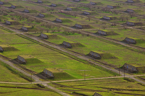
Here's a ground-level photo of yesterday's mystery site on the eastern fringes of Concord, California, from flickr user topherus:


Looking at the map, I noticed that these rails all led to the US Naval Station Port Chicago, about three miles away on the shore of Suisun Bay (the Sacramento-San Joaquin River Delta). A quick search uncovered this globalsecurity.org blurb about the base:
The Detachment’s primary purpose is the loading and unloading of large quantities of weapons and equipment from cargo and pre-positioning ships. This differs substantially from most other naval weapons stations and detachments, where weapons are loaded aboard combatants, amphibious vessels or replenishment ships one at a time or in very small groups. Base infrastructure is uniquely suited for bulk quantity operations with one floating crane, seven shore cranes, 1 superstacker, one Rough Terrain Container Handler, 342 forklifts, 101 miles of railroad track, and 79 miles of roadway. During wartime conditions, Detachment Concord has the capability to load 4,500 tons of munitions per day.
This is how frightened we used to be of the Communists: imagine building all this in order to send hundreds of bomb-packed boxcars to explode over Siberia on a daily basis, because the Russians were also planning to send hundreds of bomb-packed boxcars to explode over California on a daily basis. Stuff like this gives me some comfort in knowing that our global society isn't quite as batshit crazy as we were during the Cold War.

The base's inland portions, including those pictured above and in yesterday's post, are massive weapons bunkers, designed to transfer boxcars full of explosives into storage, and then onto waiting Navy ships. The area is currently in the process of being decommissioned, and in the course of planning for redevelopment, newly-declassified details are emerging. One "community representative" at a recent meeting learned from the Navy’s “Historic Radiological Assessment” team that nuclear missiles were stored in these bunkers, and moved through these railyards on a fairly regular basis. The "Halfway to Concord" blogger reports:

The area of these bunkers can be seen from Willow Pass Road as your approach Highway 4 looking South East, there is a set of bunkers set aside surrounded by a double wire fence with telephone poles surrounding it with floodlights on them. It was called in various documents: the Alpha Site or in RAB records as Site 22 Bunker Group 2...

The period of atomic weapon storage was ended “long ago”, but the implication elsewhere is that they removed more than 25 years ago and maybe into the late 70’s...

In the main ‘Bunker City’ area [pictured above] opposite the Dana Estates there were 6 bunkers that housed ammunition for the Phalanx Weapon System that used depleted Uranium bullets. This material is about 1/3 denser than lead, which is why it makes for a better bullet for this weapon system.
The author also notes that, in the city's redevelopment plan, much of the base would be sold off to housing developers to house 33,000 new residents. The area of these bunkers, the Grand Central station of Cold War naval warheads, would become the site of "low density ‘Estate’ style housing," which is Californian for "McMansions."

Other than the fact that Contra Costa County has averaged about 100 foreclosures a day for the past year, building new, radioactive trophy houses is probably a fantastic idea! Hey, Californians: here's some inspiration from ye olde East Coast.


PS- Kudos for commenter Jake D. in the previous post for guessing correctly what these were.

Wednesday, May 20, 2009

The Overseas Shirley


This oil tanker frequents the Portland Pipeline Corporation's oil terminals in South Portland, and was tied up to the Maine State Pier in downtown Portland for a few days this past winter for some repair work. She was last here on April 20th.

Shirley is also a felon, unfortunately.

According to MarineTraffic.com, the Overseas Shirley arrived in Portland early this morning after a stop in Halifax. Curiously, after departing from Halifax on May 14th, the Overseas Shirley took a northeasterly course towards Newfoundland, and was steaming towards Placentia Bay on the morning of May 16th, apparently destined to arrive at the Come-By-Chance oil refinery in Arnold's Cove. On the morning of May 17th, however, it was recorded steaming south out of the bay, about 10 miles away from the refinery - apparently it was either a very quick or a cancelled trip to Newfoundland's sole oil refinery.

Instead, the Overseas Shirley came here, to Portland, apparently to deliver crude oil into the Portland Pipeline and on to a larger refinery complex in Montreal. According to this Canadian history site, the Come-By-Chance refinery has had financial troubles in the past, probably owing to its geographic isolation. It seems likely that the Overseas Shirley filled its tanks with crude oil in Halifax (where, as in Portland, there are huge "tank farms" for oil storage), took some of it to Newfoundland, then delivered the rest to Montreal via the Portland Pipe Line.

Portland's harbor functions primarily as a foreign waystation for the Canadian oil industry. The United States is famously addicted to oil, but in this particular commerce, Maine plays the role of a junkie and of the cross-border mule.

Thursday, April 02, 2009

Packard's Corner, Boston, and the World's Oldest Car Park


During a bike ride through the Allston and Brighton neighborhoods of Boston last weekend, I passed by the building pictured above at a bend in Commonwealth Avenue called "Packard's Corner."

I snapped the photo because the building, which today houses apartments above first-floor shops, looked a lot like a repurposed parking garage, and the name of the building (like the name of the neighborhood) is the same as a defunct American car company, Packard Motors.

After some research, I found out that this building isn't merely a historic garage, but a historic car factory. In fact, this was the first car manufacturing plant designed by Albert Kahn, who later in his career would become famous as "the architect of Detroit."

According to the Brighton Allston Historical Society,
The name Packard's Corner refers to Packard's Sales Stable and Riding School which was located in the vicinity of Commonwealth Avenue's intersection with Brighton Avenue from 1885-1920. The Packard name was perpetuated by the important early 20th century Boston businessman and political figure Alvan T. Fuller who built the Packard Motor Car Company building at 1079-1089 Commonwealth Avenue in several stages between 1909 and 1930. This area has significant historical associations with Boston's early 20th century automobile industry. It was part of a larger "auto mile" of office buildings, show rooms and automobile related businesses which stretched from Kenmore Square to Packard's Corner along Commonwealth Avenue.

So Packard's Corner turns out to be an influential nexus in the history of Boston transportation. When the neighborhood was first known and named for its stables, the neighborhood was a hinterland. The stables occupied rural and urban spheres simultaneously.

And, in part because that's where the stables were, the neighborhood developed well-used road and street links with the rest of the city. In 1909, electric trolley service along Commonwealth Avenue helped to establish the neighborhood's dominant industry: the manufacture of automobiles and auto parts. The streetcar (which runs to this day as the B branch of the green line) enabled the transport of car factory workers and customers to Packard's Corner, which occupied a strategic middle ground between the city itself and its growing customer base in well-to-do suburbs like Brookline, just to the west. That Packard Motors happened to share a name with Packard Stables turns out to have been a coincidence (albeit one that helped potential car customers navigate their way to the showroom).

Packard Motors shut down along with Studebaker in the late 1950s, and through the late 20th century, the influence of motor vehicles on the landscape of Packard's Corner declined significantly. At some point in the late 1980s or 1990s, the Packard building was gutted and transformed into apartments, pictured above. It looks odd, with the apartment windows set back from the original windows, but the facade itself is probably preserved as a historic landmark. After all, according to the Brighton Allston Historical Society, "Kahn, in his design of the Packard building, 'deviated from traditional design to use a reinforced concrete frame and steel sash, introducing a new form of industrial architecture which combined beauty with utility.'"

In 1909, when it was built, this building was something entirely new: a reinforced concrete structure designed so that its interior spaces were substantial and open enough to handle motor vehicle traffic. In looks like a parking garage because it was designed like one: in fact, it's the first example of this type of architecture in the entire world.

Tuesday, February 10, 2009

Where is the Front Brabant?


Back in December, I'd mentioned how my friend Nate has taken on a new hobby of "shipspotting" from his third-floor apartment on Portland's Munjoy Hill, where he has an excellent view of the Portland Pipe Line oil terminal and the tankers that dock there.

At the time, I wrote that "if more curious harbor-watchers like Nate were able to accurately track the transoceanic commerce of these ships, we might have a better idea of where our oil is really coming from... Is our oil British, from the fields of the North Sea? Or Arabian? Russian? Venezuelan? For now, that's the proprietary knowledge of shipping and oil corporations - but it's knowledge that's free for the taking, for anyone with harbor views."

Since then, I've subscribed to Nate's new "Ships in Port" blog, where he's been posting updates of harbor traffic along with tidbits on the ships' histories and crews (this information is still surprisingly scarce - most oil tanker companies haven't embraced the internet, with a few exceptions). And thanks to Nate's latest post, I've learned that you don't even need harbor views to keep track of harbor traffic: new marine regulations actually require every large vessel to carry an electronic transponder, "which transmits their position, speed and course, among some other static information, such as vessel’s name, dimensions and voyage details."

Naturally, a web developer has designed a Google Maps mash-up to post the transponders' transmissions on a world map at marinetraffic.com. Here's a link to the map of what's in Portland Harbor; here's a view of Philadelphia's harbor, and here's the very busy Port of Long Beach, in Los Angeles.


So indeed, it is possible to keep track of where our oil might be coming from, by tracking the positions of the ships that visit Portland. Back on January 20, for instance, the Front Brabant was unloading oil at the Portland Pipe Line terminal. A search for the vessel on marinetraffic.com reveals that after about 2 weeks of transponder silence, while the vessel was at sea, the Front Brabant suddenly popped up again at longitude -44.22946, latitude -23.06147: the Port of Angra Dos Reis, just west of Rio de Janeiro, Brasil.

According to Wikipedia, Angra Dos Reis has "countless beaches, islands and pristine waters perfect for swimming or scuba diving," plus an oil terminal and Brasil's only nuclear power plant. If those sound like odd neighbors, keep in mind that Casco Bay, an emblem of the rugged Maine coast and a big tourism destination in its own right, also sports a major oil terminal and a major fossil-fueled power station on Cousins Island that produces a lot more pollution than Brasil's nuclear reactors ever will.

Unfortunately, marinetraffic.com doesn't reveal what cargo the Front Brabant is loading or unloading in Brasil - but my bet is that it's re-loading its hold with Brasil's soy-based biofuels. I'm planning to track the Front Brabant over the next few months to see where it goes - and where our oil comes from.

Thursday, December 04, 2008

The Fabulous Ruins of Detroit

With overpaid executives begging Congress to keep a shrinking, 1920s-era industry limping along for another few months (just in case Hummers come back in style), it seems like a good time to showcase one of my favorite websites: The Fabulous Ruins of Detroit.

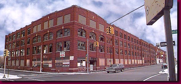
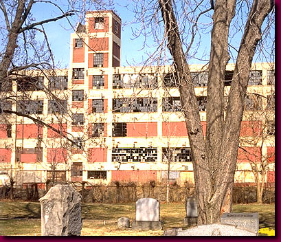
This Studebaker plant built autos between 1910 and 1928, and burned to the ground in 2005. The Studebaker corporation produced its first electric autos in 1902, and its first gasoline autos in 1904. Its car manufacturing business was defunct by 1964:


Packard Motors produced its first automobiles in 1899, and closed its last plants in 1956:


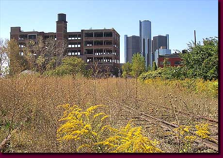
East of downtown, the former industrial Rivertown neighborhood is one of many accidental restoration sites where wild prairie ecosystems are re-infiltrating the city center. Looming in the background is "The Renaissance Center," the ironically-named GM headquarters complex, aloof from its surroundings, destined to become Detroit's next fabulous ruin.

Tuesday, September 16, 2008

The Migration Patterns of the Shipping Container

BBC News has bought a shipping container, outfitted it with a GPS Unit, and set it free to track the migration patterns of the 21st century global economy. Here's their description of the project, from bbc.co.uk/thebox:

"We have painted and branded a BBC container and bolted on a GPS transmitter so you can follow its progress all year round as it criss-crosses the globe. The Box will hopefully reach the US, Asia, the Middle East , Europe and Africa and when it does BBC correspondents will be there to report on who's producing goods and who's consuming them."
It's a brilliant journalistic conceit: everywhere the box stops to drop off or pick up a load of cargo, the BBC has a new story to tell about global business.

Moreover, the migratory routes of shipping containers are generally poorly understood to anyone who lacks an insider's proprietary knowledge. As the box moves around the globe, the BBC will track its progress on this online map, along with details about its cargo (so far, it's gone from the port of Southampton in southern England, overland to Scotland to pick up a load of whiskey, and back, by sea, to Southampton, where it's allegedly awaiting a ship to take it to thirsty Asia).  At the end of the year-long project, the BBC and its audience will have a rough map of the game paths of global commerce, and dozens of stories about the businesses, people, and economic conditions that shaped its path.

So, just as conservation biologists attach satellite transceivers to track the migratory routes of things like sea turtles to learn about the animals' habitat needs, habits, and response to things like storms and currents...


... so the BBC project should provide a rough idea of how, and where, products in the global economy respond to supply, demand, monetary crises, resource shortages, and other natural phenomena of international capitalism. I now have yet another website to track obsessively.

Monday, August 11, 2008

Migratory Industries

Late last week, a ship unloaded dozens of huge steel tubes on Portland's waterfront - the first activity at Portland's cargo terminal since a container-shipping barge ceased operations a few weeks ago. These were the segmented towers that will soon be assembled into the state of New Hampshire's first large-scale wind farm, in Lempster.


According to the local paper, "The turbines, produced by the Spanish company Gamesa, were originally headed for Fairless Hills, Pa., but were diverted because Portland proved to be a more efficient and affordable option for the shipment of the freight."

What's in Fairless Hills? A quick google search reveals that Fairless Hills is an industrial city west of Trenton, New Jersey, where Gamesa recently invested millions of dollars to build modern windmill factories on the former site of U.S. Steel. The news article is scant on specifics, but apparently these turbine parts will be shipped directly to New Hampshire and assembled there, instead of being routed through Pennsylvania, in order to save on shipping costs.

So here, on the Portland waterfront, the changing industrial migration patterns of the early 21st century are coming together like Matryoshka dolls. With a weakening economy, Maine's exports of container-shipped goods dry up. The state's only container-shipping terminal goes dormant, leaving room for a Spanish corporation to open a temporary logistics office.

Meanwhile, an abandoned steel mill in Pennsylvania witnesses millions of dollars of new investment from a European wind-energy corporation. On a site that had once imported coal and iron ore from Appalachia and exported finished steel, a Spanish company now imports steel from China to export renewable energy generators to American prairies and hilltops.

And as always, huge oil tankers come and go in a regular, unceasing beat, delivering increasingly expensive crude oil into Portland's pipeline and to the refineries of New Jersey.

Sunday, July 06, 2008

Comeuppance: the decline and fall of Ford and General Motors

"Fascism should more appropriately be called Corporatism because it is a merger of state and corporate power." - Benito Mussolini

Since 1990, Ford and General Motors have protested new fuel-efficiency standards in Washington, because improving gas mileage might make their SUV-dependent business models less profitable. Today's NY Times business section has a great story about how we can essentially thank Ford and GM for $4/gallon gas.

These GM workers were photographed protesting fuel-efficiency standards in 2002. They wanted to continue building the company's ridiculously profitable SUVs:

(Photo by Joe Polimeni, via the AP)

I like the sign that says "America Means Choice." Because now, Americans are choosing not to buy any of their piece-of-shit vehicles.

GM is shuttering several of its truck factories. Another great story in today's NY Times talks about how much it sucks to cough up a Benjamin every time you need to fill your gas tank.

Even Starbucks is worth twice as much as GM these days. Sometimes capitalism works just the way it's supposed to.

Wednesday, May 07, 2008

The city is organic.

According to the New Scientist News Service:
"French and US physicists have shown that the road networks in cities evolve driven by a simple universal mechanism despite significant cultural and historical differences. Marc Barthélemy of the French Atomic Energy Commission in Bruyères-le-Châtel and Alessandro Flammini of Indiana University, US, analysed street pattern data from roughly 300 cities, including Brasilia, Cairo, Los Angeles, London, New Delhi, and Venice."
Old world, new world, grid city or not, the researchers found that all of these cities have road networks that are mathematically similar. According to the article's abstract,
"We propose a simple model based on a local optimization process combined with ideas previously proposed in studies of leaf pattern formation. The statistical properties of this model are in good agreement with the observed empirical patterns."

The mathematical model assumed that road networks based on immediate needs to connect destinations - a downtown area to a new factory, for example, or a neighborhood to a train station. As more houses and businesses get built, they connect to existing roads. Which is exactly how capillary networks grow as new cells develop in living organisms.

This organic development of roads holds true even in cities, like Los Angeles, that ostensibly follow a north-south, east-west grid layout. LA's grid streets are only a small part of a larger, more chaotic network of big freeways (like major arteries) and tiny cul-de-sacs (like capillaries):


View Larger Map


And so, just as two genetic clones will develop different patterns of veins, capillaries, and arteries depending on chaotic environmental factors during cell growth, so a city's infrastructure develops randomly regardless of its social or governmental DNA. Whether it's a built-from-scratch city like Brasilia or an ancient city like Paris or a master-planned, for-profit city like Texas's The Woodlands, the city grows organically.

Wednesday, November 21, 2007

Welcome to Squaresville, Pops


"Hey Dad, I want you to drop me off a block from the theater."

Here's some commentary to this funny ad from Brad Aaron, a writer on New York City's Streetsblog:
"At first you think that, considering dad's expanding waistline, she's looking to get some exercise. But it turns out she's embarrassed to be seen in an SUV, since 'people in that [presumably urban] part of town are riding bikes and have hybrids and stuff.'"
Which makes sense. If her friends saw this guy driving up in an SUV, they'd draw the perfectly obvious conclusion that this is just another chubby, mid-life-critical condition who needs a big car to help him feel better about his emasculating suburban existence. Seeing a dude reduced to this is terribly embarrassing for everyone involved. I mean, check out this guy I saw in a Burger King drive-thru a few years ago:


He thinks he's the Burger King himself. I know this photo isn't easy to look at, but these people are out there, and it's tragic.

But wait! Objects Pop. This overpriced vehicle for fantasies of superiority IS a hybrid. "Like a hybrid hybrid?" asks daughter. "I don't know what a 'hybrid hybrid' is, but yes," answers Pops smugly.

They drive off. Pop's fantasy of responsible masculinity deflates slightly as he spies his receding hairline in the rear-view mirror, and a voiceover proclaims their car to be the most fuel-efficient SUV in the world. Brad Aaron speculates on the inaudible continuation of the father-daughter conversation:
"The daughter, now inaudible, explains that an anemic 34 miles-per-gallon hardly qualifies the Escape as a "hybrid hybrid" -- any more than the Chevy Tahoe is the 'Green Car of the Year' -- and asks dad why the family can't move closer to the theater so he and mom might stave off heart disease and she wouldn't have to be ferried around in 'the greenwashing machine.'"
OK, that's about enough jackass environmentalism from the auto industry, and lunch break is over. I could go on for ages, but it's like shooting fish in a barrel. Apologies for the editorial laziness.