The Indian Burial Ground in the Basement
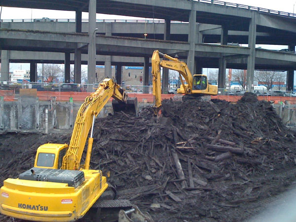
I was walking the dog this weekend along Hammond Street, a quiet residential block squeezed on the hillside between busy Washington Avenue and the industrial district of lower East Bayside here in Portland. They're building two new apartment buildings on a lot at the end of the street, and have started digging out the foundations.
Fascinatingly, the basement excavation has revealed a cross-section of the hillside, which is full of shells. Mostly longneck clams, with a few oysters here and there:


I'm pretty confident that this is a Native American shell midden — a trash heap from seafood feasts of centuries past. Though it's several blocks and a freeway crossing away from the ocean today, this hillside used to drop straight down into the tidal flats of Back Cove, as you can see in this 1837 map of Portland. The red dot shows the site of this construction site, smack dab on the old shoreline:

Back Cove is a tidal basin — exactly the kind of place where longneck clams thrive, although you wouldn't want to eat them these days. Other parts of the shore around Back Cove were probably marshy and difficult to access from land, but this location, next to a steep hillside, probably offered more direct access to the flats for humans, and for clams, there was relative proximity to the nutrient-rich tidal flows at the Cove's outlet.
I've been kind of stumped by how the shell heaps are interspersed with layers of clayey soil. This photo shows the horizontal cross-section of two layers (on the future basement floor in the foreground) as well as the sloping vertical cross-section (on the street-facing wall, in the center of the photo). At the left edge of the photo is Anderson Street, which was once the shoreline. How did all that clay get in between?


My guess is that the steep slopes of the hillside probably set off occasional landslides, which would periodically bury a heap of shells under a thick layer of mud washed down from the higher ground above.
Any archaeologists care to comment?
Related post: Longfellow's Garbage
Update: Howard Reiche e-mailed me this this morning (Sept. 11):
Fascinatingly, the basement excavation has revealed a cross-section of the hillside, which is full of shells. Mostly longneck clams, with a few oysters here and there:

The dense layers of shells are sandwiched between clayey marine soils that are typical of our neighborhood, and they follow the slope of the hillside, such that the same layers are visible twice in the excavation: once against the vertical wall on the uphill side, and once again on the floor:

I'm pretty confident that this is a Native American shell midden — a trash heap from seafood feasts of centuries past. Though it's several blocks and a freeway crossing away from the ocean today, this hillside used to drop straight down into the tidal flats of Back Cove, as you can see in this 1837 map of Portland. The red dot shows the site of this construction site, smack dab on the old shoreline:
Back Cove is a tidal basin — exactly the kind of place where longneck clams thrive, although you wouldn't want to eat them these days. Other parts of the shore around Back Cove were probably marshy and difficult to access from land, but this location, next to a steep hillside, probably offered more direct access to the flats for humans, and for clams, there was relative proximity to the nutrient-rich tidal flows at the Cove's outlet.
I've been kind of stumped by how the shell heaps are interspersed with layers of clayey soil. This photo shows the horizontal cross-section of two layers (on the future basement floor in the foreground) as well as the sloping vertical cross-section (on the street-facing wall, in the center of the photo). At the left edge of the photo is Anderson Street, which was once the shoreline. How did all that clay get in between?

Stranger still is how some of the shell layers seem to overlap with each other:

My guess is that the steep slopes of the hillside probably set off occasional landslides, which would periodically bury a heap of shells under a thick layer of mud washed down from the higher ground above.
Any archaeologists care to comment?
Related post: Longfellow's Garbage
Update: Howard Reiche e-mailed me this this morning (Sept. 11):
 |
| The Knudsen home, which stood on the site until this summer. From the City of Portland's 1924 tax records. |
Good for you. That was my grandfather’s (Knud Knudsen) house where he raised 13 children after immigrating from Denmark. We have a family photo of my mother, Laura Christine (Knudsen) Reiche, feeding the ducks in the water which came to the foot of their garden which I walked in many times..
Hammond St. was named after the Hammond rope walk which was originally at that site. Possibly the “layers of clay” mystery had something to do with the construction or changing of the rope walk.