Showing posts with label NYC. Show all posts

Wednesday, May 14, 2014

Art laundry

Postcard, c. 1900, from the Detroit Publishing Company collection. Courtesy of collection Marc Walter / published in An American Odyssey (TASCHEN, 2014). 


Central Park Gates, by Jean Claude and Christo, 2005. Photo courtesy of The City Project.

Thursday, February 28, 2013

The Chase Manhattan Bank of Cholera

You probably know that Aaron Burr murdered Alexander Hamilton in a duel. But I recently learned of Burr's surprising and grotesque role in some of New York City's worst plagues — including one we're still suffering through to this day.

My dad recently gave me a fascinating (but not online, unfortunately) medical history of New York City's water supply by Dr. David E. Gerber, from which I learned this:
"In 1799, New York City passed on the responsibility of constructing and maintaining a waterworks to the newly charted Manhattan Company. The company, the brainchild of the improbable team of Alexander Hamilton and Aaron Burr, received from the state legislature a mandate to supply New York City with 'pure and wholesome' water."

Left: Manhattan Company log pipes excavated in 2004 near Coenties Slip. Via New York City Walk (photographer unknown)

But the Manhattan Company was terrible at providing "pure and wholesome water." They employed cheap wooden pipes and instead of procuring fresh Bronx River water, as had been proposed by city officials, they dug wells on the outskirts of the growing city (near today's Greenwich Village) where the water supply quickly became polluted with the city's sewage, or dried up altogether from overuse.

So in spite of a $2 million charter from New York's state government, the growing city continuted to suffer from polluted water. In 1832, the very first year that cholera arrived in New York City (from Asia, via overseas trade), 3,515 New Yorkers died.

There was a reason why the Manhattan Company was so negligently, fatally incompetent at its purpose: it was run by some of the city's earliest investment bankers, including the murderer Aaron Burr.

At Burr's initiative, the Manhattan Company's charter was amended shortly before it took effect to allow the new company to spend its excess capital "in any way not inconsistent with the Constitution and laws of the United States."

The Legislature and Burr's business partner, Alexander Hamilton, seemed to believe that this would allow for additional, future waterworks. But Burr almost immediately exercised this clause to capitalize a new bank, using the money intended for waterworks to give out loans to New York merchants.

The Bowery Boys, the New York history podcasters, have an episode on the Croton Aqueduct that tells some of this same story, and they put it this way:
"There was a banking monopoly where you had the US Federal Bank [i.e., Alexander Hamilton's First Bank of the United States] and the Bank of New York, which was founded by Hamilton, Burr's rival and victim. Burr and his company got a $2 million contract from the state legislature to bring fresh water into New York City.

They decided to spend it thusly: $100,000 on waterworks and bringing fresh water into the city — so 1/20th of the total — and $1.9 million on creating a bank!"

Providing "pure and wholesome water" was just a distracting sideline. In fact, the more the Manhattan Company spent on public waterworks (there were no water meters back then, thus no reliable user-fee system, thus no profit motive), the less they had to spend on high-interest loans to New York City's merchant class.

Hamilton evidently didn't like the competition from a new bank in town: he left the Manhattan Company shortly after Burr capitalized his new bank with 1.9 million New York State taxpayer dollars.

The citizens of New York suffered the Manhattan Company's filthy water until 1842,  when the City of New York finally opened an aqueduct from the Croton River, which provided public drinking water that was genuinely pure and wholesome, and does so to this day.

So New York eventually addressed its sanitation problems and cured its epidemics of cholera and yellow fever.

Unfortunately, Aaron Burr was only an early vector in New York City's raging plague of assholes who collect millions of dollars from the government in order to enrich themselves in the global banking casino.

In 1955, Aaron Burr's Bank of the Manhattan Company merged with the Chase National Bank to become Chase Manhattan. And in 2000, Chase Manhattan bought out the investment firm JP Morgan to become JP Morgan Chase, on whose website you can today download a short history that tells part of this very same story. This document includes some pictures of old wooden pipes and a quaintly threatening engraving (below) of their company's founding chief executive ballistically perforating the Founding Father on our $10 bill.

However, somehow JP Morgan Chase's PR department neglected to mention the part about all the cholera — hopefully they'll appreciate this addendum.


Monday, October 29, 2012

Buried Wetlands Rise from the Grave

This evening, Hurricane Sandy's storm surge will combine with astronomical high tides to give eastern seaboard cities an exciting preview of sea level rise. Forecasters are predicting storm surges up to 10 feet above the average high water mark — especially in western Long Island Sound and New York Harbor, where the storm is funneling massive volumes of seawater into the right-angled corner formed by New Jersey and Connecticut.

As I wrote last week in Grist, most big cities have buried their wetlands and creeks underground. But big storms and flood events like this one have a way of making those hidden waterways reassert themselves, as underground sewers and stormwater channels fill up beyond their design capacity and overflow into the streets above.

That can happen in unexpected places. Here in Portland it wasn't even particularly stormy today, and there was only light rain. But the astronomical high tide did push water up to the surface of Somerset Street, four blocks away from Back Cove (note the empty tree wells — similar events killed the street trees planted here in 2006 due to salt water in the roots).

Meanwhile, in Philadelphia, heavy rains may once again cause problems in the sewer-bound Mill Creek.

And in New York City's Boerum Hill and Park Slope neighborhoods, the old marshes of the Gowanus Canal may once again take over the streets. This overlay of the Brooklyn section of the 1782 British Headquarters Map shows (roughly) how far the old marshes of the Gowanus used to extend across central Brooklyn:
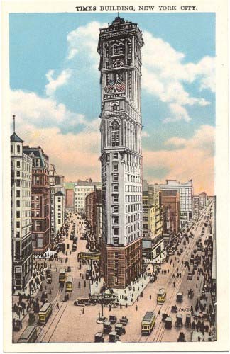
Tuesday, September 18, 2012

How an Icon of Journalism Became a Hollowed-Out Billboard

When it was built at the southern end of Longacre Square in 1903, the new headquarters of the New York Times became a landmark of midtown Manhattan, and helped publisher Adolph Ochs convince the city to rename the famous intersection in front of the building as Times Square.

One Times Square in 1904 (source).One Times Square in 2010.
Photo: Bernt Rostad/Flickr
By the mid-20th century, though, the Times had sold the building, and a new owner dismantled the intricate granite and terra-cotta facade to replace the exterior walls with plain concrete panels. In 1996, shortly after the City Council passed new laws that expelled porn theaters from the area, the building got sold again, to Sherwood Outdoor, an advertising firm. By then, the building's signage was covering most of the exterior windows, leaving the offices inside rather dark and dreary.

Rather than spend money to renovate, the new owners decided to simply abandon the building's interior above the 3rd floor, and use the top part of the building exclusively as a billboard (the lower 3 floors are still used, periodically, as retail space — it's currently a Walgreens drug store).

So for the past 15 years, the iconic building that was the namesake of Times Square itself, and a major headquarters of journalism, has become a hollowed-out shell, a mere scaffold for electronic signs.

At the Crossroads of the World, the value of advertising has trumped the value of journalism, and of work in general. 


Postscript: Illustrator Joe Mckendry has made a gorgeous before-and-after elevation drawing of the building's eastern facade in 1904 and in 2010, for his book One Times Square.

Wednesday, May 09, 2012

Ten thousand public bikes bloom in Manhattan

Later this summer, New York City city will roll out thousands of publicly-owned bikes parked at stations, spaced a few blocks apart across three boroughs, where visitors, workers, and neighborhood residents will be able to borrow a bike for short-term rentals.

Lots of other cities have already pioneered the bikesharing idea (even Houston, Texas managed to implement bikesharing before New York did, with a much smaller 3-station downtown network that opened this spring). With origins in Paris and Montreal, bikesharing has always had a tinge of utopian socialism to it, promoting the shared use of public property over privately-owned vehicles.

But it's a socialist idea that works brilliantly, thanks to mobile technology: users can use their smartphones to locate bikes and a station near their destination, while bikeshare managers can locate lost or broken bikes with GPS, and dynamically track which stations need more bikes due to high demand. Lots of new business startups seek to duplicate the same communistic idea of letting people share their private property (whether spare bedrooms or automobiles) in exchange for small rental payments. Bikesharing makes cycling in cities easier, cheaper, and more fun, resulting in more people riding bikes for short trips in the cities where it's been established.

Private property, it turns out, is a hassle to take care of. But new technology allows people to enjoy the communitarian benefits of shared property thanks to the capitalist accountability of credit card security deposits and rental payments.

New York City's state-owned bicycles wholeheartedly embrace this ironic marriage of utopian environmentalist socialism with hard-nosed capitalism. They've been named "Citi Bikes," after Citibank, which contributed a $41 million for the naming rights.

Wall Street quants riding to work like Maoist factory workers (although even Maoists own their own bikes) will do so astride bikes plastered with the Citibank logo, and pay at stations that prefer MasterCard, another corporate sponsor.

And so here is a photo, via Streetsblog, of three transportation policy wonks (from left: NYC Deputy Mayor Robert Steel, Alta Bikeshare CEO Alison Cohen, NYC DOT Commissioner Janette Sadik-Khan) and three billionaires (Mayor Michael Bloomberg, MasterCard CEO Ajay Banga, and Citigroup CEO Vikram Pandit).

In a few more years, bikesharing stations will be as much a part of our stereotypical vision of the generic urban landscape as newsstands and bus shelters are today.

Saturday, March 17, 2012

David Lynch's Nature Film

Hollywood types supposedly love making heavy-handed ecological allegories to brainwash us into being more considerate and thoughtful. It turns out that David Lynch was no exception. Here's a short film about inner-city wildlife in Lynch's signature "neo-noir" style, from 1991:

Monday, April 04, 2011

The Utopia Over the Freeway

The Bridge Apartments in Washington Heights. Photo used by permission from photographer Mario Burger,
Burger International, Inc.
.

Last fall, the Cooper Union hosted a show dedicated to Paul Rudolph's Lower Manhattan Expressway (or LOMEX) proposal - a design study intended to enamor New York City's modernist architectural elites with Robert Moses's freeway-building ambitions.

Rudolph was a genius draftsman, and he produced stunning drawings that manage to generate a sense of futuristic optimism and excitement around the idea of living above thousands of exhaust pipes stuck in traffic:


One of Paul Rudolph's LOMEX studies.


From at least the 1930s, when Moses was in charge of the Parks Department, New York's "Master Builder" wanted to build a freeway through lower Manhattan, connecting New Jersey to Brooklyn by way of the Holland Tunnel and the Williamsburg and Manhattan Bridges. Interestingly, Paul Rudolph's proposal came only during the Lower Manhattan Expressway's dying days, and only at the sponsorship of the Ford Foundation.*


Jane Jacobs had published The Death and Life of Great American Cities seven years previously, in 1961; a year after Rudolph began his study of the Expressway, in 1968, Governor Rockefeller would freeze Moses out of the city's transportation agencies. By the time Rudolph stopped working on this proposal in 1972, the city was on the verge of bankruptcy and grand building schemes like this one were relegated to the realm of fantasy. In a review on the Design Observer blogs, Mark Lamster wrote that Rudolph's was "an extraordinary vision, if not a practical one."


Rudolph's drawings are indeed amazing, especially the ones that compare the hugeness of his vision to existing landmarks (the red drawing above frames the towers of the Williamsburg Bridge, which is huge in its own right, in the center).

The show is powerful not just for its audacity, but for what we know now, forty years later, when the historic neighborhoods that Rudolph and Moses would have liked to have bulldozed are worth hundreds of billions of dollars. In hindsight, it's easy for us to say, "something like that could never actually happen."

Except for one thing: something like Rudolph's vision actually did happen. A few miles away, on the same island of Manhattan, urban renewalists and highway builders had actually finished a massive cross-island expressway, topped with apartment towers and a major transit hub, several years before Paul Rudolph started designing the LOMEX.


The new Trans-Manhattan Expressway seen from a tower of the George Washington Bridge. Photo from the LIFE Magazine archives.


This is the Trans-Manhattan Expressway, also known as I-95, the only Interstate highway that crosses Manhattan Island. It was opened in 1963, when a second deck was added to the George Washington Bridge to New Jersey. It crosses the island in Washington Heights, where the island is only one mile wide, but its construction still required the demolition and clearance of dozens of buildings on eight dense city blocks.
When the Expressway opened in 1963, Robert Moses, the freeway's champion, foreshadowed Paul Rudolph's work to come later in the decade:

"This is the first expressway to be built across Manhattan, and we hope that the Lower Manhattan and Mid-Manhattan expressways, both of which have been the victims of inordinate and inexcusable delays caused by intemperate opposition and consequent official hesitation, will follow. These crosstown facilities are indispensable to be effectiveness of the entire metropolitan arterial objective of removing traffic through congested city streets."

Of course, the scorn for opposition that Moses has on display in this quote was even then sowing the seeds of his downfall. And with the benefit of hindsight, it's easy for us to chuckle at the notion that building a fast and convenient route for cars and trucks to enter Manhattan would do anything to remove any traffic from New York's streets:

Photo by Zach K.


The Trans-Manhattan Expressway wasn't merely a freeway, though. It was a linear megastructure that stacked a complex of modernist transportation hubs and huge apartment blocks overhead. On the western end, Moses built a winged bus terminal that squatted over the freeway's entrance ramps:

Looking west towards New Jersey over the new Trans-Manhattan Expressway and the George Washington Bridge bus terminal. Photo courtesy of the Port Authority of NY-NJ.


George Washington Bridge bus terminal. Photo by gezellig-girl.com.


On the eastern end, the city sold development rights to private developers who built four enormous apartment towers, known today as the "Bridge Apartments." The New York Times did a story a few years ago called "Life on the Road," a chronicle of the apartments' history and what it's like to live there. "If the windows are open, the noise is most deafening on the middle floors, and people inside find that they need to raise their voices to hold a conversation or talk on the phone," writes reporter David Chen. "The winds carry vehicle exhaust upward, which is especially noticeable on the terraces. And on most floors, the vibrations of trucks can clearly be felt, along with those of any construction equipment."


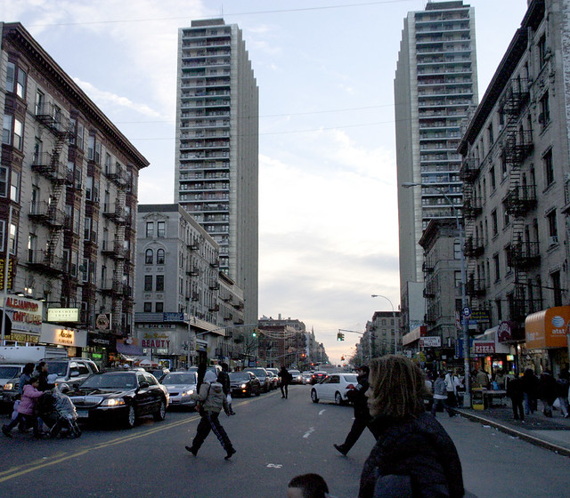
Two of the four Bridge Apartment towers, which mark the path of the Trans-Manhattan Expressway beneath. Photo by Zach K.


The Bridge Apartments loom over Washington Heights like mother ships from a sci-fi movie. I remember catching sight of them from time to time when I worked as a park ranger in Inwood Hill Park, two miles away, and being startled by their incongruous appearance on the skyline. This in a city known for its tall buildings - but the four towers, lined up in a row and hulking over a major freeway, have an otherworldly quality to them (Mario Burger's photo at the top of this post is the best illustration of this feeling that I was able to find online).

In all the reviews I've seen of Rudolph's show, I'm surprised no one has mentioned the Trans-Manhattan Expressway. It was obviously a major precedent in Rudolph's mind and in his designs - when he began working on LOMEX, the Trans-Manhattan Expressway would have still felt new and futuristic, not yet dated and dingy with soot and exhaust as it is now.

And for those modernist romantics who wonder at the ambitions of people like Robert Moses and Paul Rudolph, and yearn for a future that might have been: the gritty reality is on plain view to all in Washington Heights.


*The Ford Foundation's involvement in promoting LOMEX was probably not a self-serving effort to get more New Yorkers into Fords, as I'd initially suspected. By the late 1960s, the Ford Foundation, most famous for sponsoring the Corporation for Public Broadcasting, was separating itself from the Ford Motor Company through stock divestiture and new members of its Board of Directors (source). Instead, the Foundation seems to have hired Rudolph in a well-meaning - if misguided - effort to promote "urban renewal" in what were then some of the city's most impoverished neighborhoods.

Monday, November 29, 2010

The abandoned spaceport

I finally made it to Flushing Meadows Corona Park last weekend to visit the ruins of the 1964 World's Fair. Technically, the abandoned New York State Pavilion is closed to the public, but the fence is poorly maintained and it's easy to sneak in:


And here's how it looked in 1964:


The park is an hour's bike ride from the Queensboro Bridge, or you can ride the 7 train to the Mets-Willets Point station. If you're in NYC, visit soon before the Parks Department fixes the fence, or worse, tears down the historic structure altogether.

Much more to come about Flushing Meadows Corona Park in future posts here...

Thursday, October 28, 2010

Marble Hill in Manhattan (not the Bronx)

I recently discovered* Pathological Geomorphology, where various geobloggers share "images of extreme landscapes, landforms, and processes," organized around a monthly theme. Last month was dedicated to landslides, for instance. This month: "the juxtaposition (or superposition) of distinctly human-made landscapes with nature's geomorphic forms."

This immediately reminded me of Marble Hill, a neighborhood in the borough of Manhattan that is physically attached to the Bronx. Here's an aerial view - to orient you, this is the Harlem River ship canal where it curves around the northern tip of Manhattan. A small corner of the Hudson River is in the upper-left corner, and Broadway, and the West Side IRT subway lines, run diagonally from the middle of the bottom edge to the upper right-hand corner:


You can clearly see a looping s-curve through the middle of the picture. It's the old course of the Spuyten Duyvil Creek, which was widened and straightened in the nineteenth century for use as a ship canal between the Harlem and Hudson Rivers. On the left side of the photo is Inwood Hill Park, where I worked as an urban park ranger in 2005. The old creek is still more or less a waterway there, though it's been filled in substantially. The nature center and baseball field at the northeastern entrance of the park (the small peninsula left of center in the photo above) actually used to be connected to the Bronx.

The eastern loop is more interesting. It's been completely filled in - parking lots, warehouses, and big box stores now occupying the former creek bed. But the streets still trace the lines of the historic creek banks. The neighborhood between the new ship canal and the old creek bed is called Marble Hill. It was attached to Manhattan Island until 1895, when the ship canal sliced it off and marooned it as an island. Here's a map from that turn-of-the-century period, via Forgotten New York:


The creek was filled in 1917 to attach Marble Hill to the mainland of the Bronx, but the neighborhood, for political and judicial purposes, remained in New York County, and the borough of Manhattan.

I've heard, anecdotally, that a number of Marble Hill residents still insist on snubbing the borough that surrounds them by telling people they live in Manhattan, which sounds more upscale than the Bronx. So, while the historic geomorphology of the former Spuyten Duyvil Creek does survive to this day in a ghost-pattern of street layouts and land uses, it survives in a more tangible sense in the neighborhood's civic affairs and a general sense of inter-borough snootiness.

Of course, this is probably my best example of how ancient geomorphic forms have influenced human-made landscapes - but I've already written about that one.


*via mammoth, another blog I've discovered and really come to enjoy in the last couple of months - it writes extensively about urban infrastructure and how it relates to our economy and ecologies. If you like this blog, you'll enjoy theirs, too.

Tuesday, June 01, 2010

A Park Gained, A Wilderness Lost

When I was in New York a few weeks ago, I finally made a visit to the High Line, the city's new park on an abandoned elevated rail line on the west side of Manhattan.

The High Line, in 2007 and in 2010 on TwitpicLeft: the High Line in 2007 and in 2010: cultivating native plants and overpriced condo towers. Click to enlarge.

I had been pretty excited about this park for a long time - I first learned about it in 2006, the year I was working for the City as an Urban Park Ranger, when the project first broke ground. For me, the High Line was a vindication of my idea that a city's hidden pockets of wildness - often on the forgotten margins, like the abandoned industrial neighborhood around the High Line - could be celebrated for their unique ecosystems and natural resources, instead of being condemned as "blight."

Since it's opened to the public, there can't be any doubt that this abandoned railroad has been a cause for celebration from residents and tourists alike.

But when I visited last month, I had to wonder if something was lost in the High Line's transition from abandoned railroad to public park. The High Line is stunningly designed, packed with native plantings, and it's opened up new ways for New Yorkers and visitors to experience the city.

But is it wild anymore?


The High Line in 2001, by Jonathan Flaum:
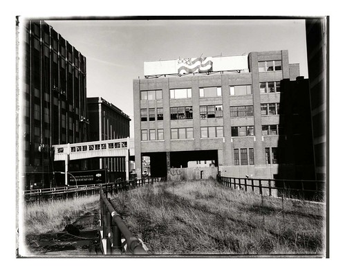
And in 2009, via Inhabitat:


The overwhelming impression I got from walking on the High Line this spring was of wealth. The park was clearly expensive to build, with tropical-wood furniture, elaborate fountains (they were under repair while I was there), and meticulously tended foliage. The carefully selected varieties of native plants were evenly, geometrically spaced in mulched planting beds outfitted with an irrigation system. A forest of new condo high rises and hotels, designed by global celebrity architects, loomed over the rehabbed warehouse buildings of the former industrial district.

Great architecture is all well and good. But I found that the High Line, in its "finished" state, was less like the wilderness I'd hoped for, and more like a formal garden for the gentry of Chelsea: a sort of post-industrial Versailles.

I feel like this is a missed opportunity. After all, ostentatious displays of wealth in New York City are not all that compelling or interesting - they're pretty much a dime a dozen.

The High Line, before it was a park, had been a refuge from a landscape obsessed with capitalizing and selling every square foot of space. Here there were acres of land that existed outside of the consciousness of real estate, where weeds, small mammals, birds, and the occasional human adventurer were free to wander in a two-mile meadow, simultaneously above and surrounded by the city. That's where it derived its wildness.

As a landscaped park, though, the High Line is obviously a real estate amenity. When every prospect offers views of shiny condo towers and expensive lofts in expensively rehabbed warehouses, and designer signage implores you to stay on the designer concrete pathway, it's obvious to the visitor that this park was financed and built by developers and neighbors angling to increase their own property values. In the process of becoming a public park, the High Line became co-opted by New York City's real estate juggernaut.

In the process, an essential part of the High Line's promise - its freedom, and isolation from the commodification and control of New York City's landscape - has been lost.*

The new High Line park's design also botches the structure's historical context. Until 1980, the High Line railroad had been used to deliver agricultural raw materials to various food processing plants in the neighborhood. Refrigerated boxcars full of cows, for instance, were delivered to the slaughterhouses of the Meatpacking District. Several spurs curve from the main line into adjacent buildings, and in some places, the High Line actually travels through the middle of buildings, with old loading docks on either side.

Here's a photo from the mid-twentieth century of the High Line where it runs through the National Biscuit Company (a.k.a Nabisco) complex. These are the same buildings pictured at the top of this post:


For decades, then, the High Line (and its surrounding neighborhood) played an important role in feeding New Yorkers, and commodifying the agricultural bounty of the Midwest into value-added processed foods. There's a rich historical narrative here about the industrialization of agriculture, the centralization of food processing, the rise of supermarkets... but there's no trace of any of this in today's High Line Park.

This was the other big thing that unnerved me about walking along the High Line. The structure's wrought-iron railings, steel I-beams, and the handful of high-ceilinged brick warehouses surrounding the old railway clearly hearken back to a lost industrial past. But everything about the park itself, and the expensive architecture that surrounds it, drives home the fact that that industrial past is entirely gone. This used to be a neighborhood that made things and trafficked in the heavy, bulky products that required massive railroads to move. The High Line itself used to be a vital connection between the City and the natural resources that fed it.

But today, the neighborhood traffics in abstractions: there's tremendous wealth here, but it's anyone's guess where it comes from.

Back in 2007 I wrote about how the abandoned High Line illustrated the ecological succession of urban vacant lots
:
Over the years, more dust, leaves, and soot blew in. Each fall, the topsoil gained another layer of dead grass and leaves from pioneer weeds like goldenrod, Queen Anne's lace, and Ailanthus Altissima... the new High Line park will have benches, new concrete paths, easy access from the street level, and drought-tolerant landscaping that mimics the wild weeds that inspired the park.

It might seem like an interruption and commodification of the wild successional process, but New York is nothing if not habitat for homo sapiens, and the new High Line fits in perfectly with New York's typical neighborhood succession: places once run-down and diverse inexorably become unaffordable and boring. At least until the next large disturbance, anyhow.
When the new park opened in 2009, we were in the middle of a huge financial crisis that seemed to hold out the promise of being that "next large disturbance." Here's an excerpt of the post I wrote at the park's grand opening:
In the new economy, the High Line feels a lot weirder. It was meant to be a futuristic preserve for New York's past - especially its overgrown lots and abandoned industrial infrastructure. Now that the park is open, though, the ultra-slick High Line feels a bit out of place. Instead of evoking New York City's past, the High Line looks more like an expensive simulation of conditions in inner-city Detroit, or of a foreclosed backyard, or of any of the thousands of newly-defunct car dealerships nationwide. Those conditions were rare in New York City two years ago, but now that they're fairly commonplace in society's consciousness, the High Line seems more artificial and contrived.
Now that I've been there, though, I realize that the High Line doesn't feel anything like Detroit or an abandoned car dealership. That's its problem: it lacks any relationship to the economic or environmental conditions of the city. Instead, it sits aloof from the street, a walled garden guarded against the weeds and the history that used to reside there.

But the views are nice, I'll grant it that.


*Footnote: This is related to the age-old debate about whether we can open up "wilderness" areas to the public without ruining the essential qualities that make these areas feel wild - namely, their isolation and freedom. I'm typically inclined to believe that this is not a real trade-off, especially if we can help people appreciate the relative abundance of places like the (old) High Line that exist right under our noses, in our cities and neighborhoods. Cultivating a sense of stewardship for these places, whether they're in an abandoned downtown area or in a national park, will let more people enjoy them without necessarily "ruining" them.

Unfortunately, in the case of the High Line, we (the public) have surrendered our responsibilities of stewardship to profit-motivated architects and developers.


Saturday, April 24, 2010

Safari 7: a wilderness tour of Queens


During a few days spent in New York, I had a chance to briefly visit the Safari 7 Base Camp, set up in Grand Central for Earth Week.

Safari 7 is pretty much exactly what I have been thinking about doing ever since I worked as an Urban Park Ranger a few years ago in Inwood Hill Park: a guided tour that highlights nature and ecology in the places we typically overlook those things. I'm glad that someone actually had the initiative to make it happen. From the project's description:

“The 7 line is a physical, urban transect through New York City's most diverse range of ecosystems. Affectionately called the International Express, the 7 line runs from Manhattan's dense core, under the East River, and through a dispersed mixture of residences and parklands before terminating in downtown Flushing. Safari 7 circulates an ongoing series of podcasts and maps that explore the complexity, biodiversity, conflicts, and potentials of New York City's ecosystems. Tours are available online and can be experienced independently, or in group expeditions and workshops organized by the Safari 7 team.”


The "Base Camp" at Grand Central included an array of gorgeous banners that highlighted things like the aquatic wildlife of the East River, the ecosystems of decomposition at work in the city's huge “cemetery belt,” and the dual role of urban chickens, as food sources and as illegal fighters. The centerpiece of the project is a series of podcasts, short enough to listen to between stops, that describe various ecological phenomena at work at each stop along the line.

Thus, as you ride under the East River, you can listen to a podcast about the tiny island formed from that tunnel's excavation, and learn about the cormorants that nest there. Or hear about the ecology of courtyard gardens in Queens, while you try to get a glimpse of one from the elevated portion of the line.

Over the next few weeks, I plan to write more about those individual podcasts and some of the issues they discuss in more detail. Much of the subject matter isn't unique to Queens - no matter what city or backwoods internet-enabled cabin you live in, there's something for you to learn about your own human habitat. Visit safari7.org to download your own safari audio tour.

Monday, January 11, 2010

Haliaeetus leucocephalus in the Heights


The people at the Trinity Church Cemetery and Mausoleum in Manhattan's Washington Heights snapped these photos of an American Bald Eagle, enjoying a lunch plucked from the Hudson in a tree near the cemetery offices. It's a big fish - maybe a striped bass?

This just happens to be the same cemetery where the famed naturalist John James Audubon has been buried since 1851. During most of Audubon's lifetime, bald eagles were a common sight in the ecologically-rich Hudson River estuary, which had been a teeming mixing-basin of saltwater and freshwater habitats. But by the mid-nineteenth century, sewage and industrial waste from the booming city (in an era without pollution controls) laid waste to the estuary's food chain -from the oysters near the bottom to the bald eagles at the top.

The Clean Water Act and other environmental laws of the 1960s and 1970s gave the Hudson River a chance to recover, though. Fish came back, but state and federal wildlife programs had to resort to importing eagles from Canada in order to lure the big birds of prey back to the city.

In the summer of 2006, when this blog was just getting started, I was part of the Urban Park Rangers team that maintained a bald-eagle hack site in Inwood Hill Park on the final year of a five-year program (here are some of my photos). Eagles typically wander around for a five-year adolescence before returning to nest near the place where they were raised, so it tickles me to think that this bird in the Trinity cemetery might be one that was raised in Inwood Hill Park.

Birdwatchers in New York City can look for this eagle themselves at 770 Riverside Drive, between 153rd and 155th streets.

10031

Thursday, October 04, 2007

More Mannahatta

Amazing...


From the New Yorker's online slideshow, a supplement to Nick Paumgarten's highly recommended article on the Mannahatta Project.

Related:

Wednesday, October 03, 2007

The Mannahatta Project

There's a great article in the most recent New Yorker about the Wildlife Conservation Society's Mannahatta Project, a forensic ecology experiment that attempts to envision what Manhattan Island might have looked like before European settlers arrived.


The project is just getting underway, but its investigative naturalism sets my heart a-flutter. Researchers are poring over historical maps, surveys, and archaeological evidence to re-create a long-lost landscape.

Of course, there are two ways to interpret this project: there's the "paradise lost" perspective, which compares the Manhattan of today to the Mannahatta of 1609 and bemoans the loss of wild nature. Certainly that attitude is tempting when we consider how Manhattan Island was once surrounded by two incredibly rich tidal estuaries, which once helped to sustain some of the richest oyster beds on the planet in addition to a spectacular diversity of migrating birds and terrestrial fauna.

But dismissing Manhattan as "paradise lost" discounts the ecological diversity that still exists in the city, and loses sight of the fact that people are a part of nature, too.

The island's ecological richness is precisely what attracted people here in the first place: first the Lenape Indians, then the Dutch, then the entire world. So a more productive way of interpreting the Mannahatta project might be to look at the island not as "paradise lost," but as paradise changed, with fewer oysters but a lot more people. Through these recreations of pre-European habitats, the WCS hopes, "we will discover a new aspect of New York culture, the environmental foundation of the city... Today’s New Yorkers use the landscape in a much different way, but have the same fundamental needs, [and] finding ways to meet our needs while sustaining the natural processes on which we depend is the most important question of the 21st century."

If this project helps people imagine the wild nature that once existed here, I would hope that it will also help New Yorkers better appreciate and understand the wild nature that still survives - from the big, wild parks like Inwood and Pelham Bay to the scraggly Ailanthus trees growing out of the pavement in Red Hook.

Learn more here: The Mannahatta Project

Thursday, August 16, 2007

Lower Manhattan, then (in 1757) and now

Lower Manhattan today...


...and as it was in 1757. In both views, the street running up the center is Broadway.

Note the "Collect Pond" in the historic map, near present-day Foley Square. This spring-fed pond was once New York City's main source of drinking water, until the pollution from tanneries and thousands of chamberpots made it unfit for consumption. After one too many typhoid outbreaks, the City drained the pond by digging a 40-foot trench that drained into the Hudson. That trench is now Canal Street.

Also note how Lower Manhattan's original Hudson River waterfront was beneath present-day Greenwich Street.

As with last week's historic map of Portland, Maine, you can download this overlay as a Google Earth KML file. Use the opacity slider to transition between the 1757 map and the present-day satellite view - it's pretty neat.

Also, if you enjoy these historic map overlays of modern-day cities, you might also be entertained by the Strange Maps blog, which kind of inspired this little project. And here's a Brooklyn blogger's investigation into the history of his own neighborhood's street grid.

Previously: The Sepulture of Portland Harbor. Next week, we'll head out west to Los Angeles!

Saturday, August 04, 2007

Escape From New York

Back in the late 1970s, John Carpenter wrote and directed a movie based on the premise that Manhattan Island would be abandoned and turned into a maximum-security prison by 1997.

"Escape from New York" (which has a highly recommended Wikipedia article) nicely sums up the pessimistic attitudes people had about our cities only 30 years ago. The movie was actually filmed in East St. Louis, where a massive urban fire had reduced hundreds of downtown blocks to rubble. The city had suffered one of the nation's worst cases of white flight, and its bankrupt government had no objections to its streets being used as a post-apocalyptic movie set.


Mort Gerberg cartoon from the New Yorker, 2002.
Fifteen years later, Giuliani was Disneyfying Times Square, and urban desperation had followed its manifest destiny westward to Los Angeles. "Escape from LA" came out in 1996, following the Northridge earthquake, the Rodney King riots, and OJ Simpson's terminal celebrity. The movie's plot, about a religious fascist who rises to power when "the big one" floods the San Fernando Valley, both exploited and mocked the 1990s' national hatred of Southern California.

In 2007, we still have spectacular urban disasters: 9/11, Katrina, the bridge collapse in Minneapolis. And yet (with the possible exception of New Orleans) these disasters don't elicit fantasies of abandoning/escaping our cities. In the real-life 21st century, the closest thing we have to "Escape from New York" is a weekly section of recommended vineyard tours and golf resorts in the Times.

In fact, most of our 21st-century penal colonies are actually being built in economically-depressed rural hinterlands. Perhaps "Escape from Berlin, New Hampshire" could be a part of Kurt Russell's retirement plan?

Tuesday, July 10, 2007

Red-tailed hawks are awesome

This is a red-tailed hawk that lives in Washington Square Park, in the middle of New York City's Greenwich Village. It is eating a pigeon on top of the New York Daily Photo blogger's air conditioning unit.

Red-tailed hawks are doing quite well in Manhattan: they have nests in Inwood Hill Park at the northern tip of the island (where I worked last summer) and in Bowling Green Park near the Battery, as well as in many places in between. They feast on the city's bounty of fat pigeons and nest either on the ledges of high-rise buildings or in dense tree canopies in city parks.

I had the good luck to witness a red-tailed hawk hunting high above Broadway last summer. I was walking down the street towards the subway station when I heard a red-tail's scream above me. I looked up just in time to see an explosion of feathers burst from the middle of a panicked mob of pigeons, and the burdened hawk coasting out from the middle of it and into the trees in Isham Park.

I've lived in the New Hampshire wilderness, hiked at the edges of the Tibetan plateau, skied down volcanoes, etcetera, etcetera, but watching a red-tail eviscerate a pigeon a hundred feet above Broadway in New York City ranks among the most amazing spectacles of nature I've ever witnessed.

Wednesday, April 18, 2007

Whale watch in the Gowanus Canal

Brooklyn's Gowanus Canal isn't exactly teeming with wildlife the way it was in 1630, when the Dutch government first began to take an interest in Brooklyn real estate. A network of creeks in the area once drained a network of wild salt marshes and meadows; nearly four centuries of European settlement have paved the banks and straightened out the watercourse into one channel surrounded by auto shops, oil tanks, scrap yards and all-you-can-eat PCBs.

But if you think that the Gowanus Canal is the antithesis of nature, there's at least one baleen whale that would disagree:


This critter swam into the Gowanus Canal yesterday and immediately became a New York City celebrity (the local tabloids dubbed it "Sludgy the Whale"). What makes the story even more incredible is the fact that the heavy rains associated with the Patriot's Day storm had overloaded Brooklyn's sewers and sent thousands of gallons of raw sewage into the canal (see The New Watersheds, my post on New York's sewer system that I wrote while working as an Urban Park Ranger last summer).

Sludgy didn't swim into the Gowanus to make a point, but that won't stop me from making on on her behalf: for all the concern that exists in our cities for our natural environment, and for all of the laments over the loss of "wild nature", we too often disregard the wild places that still exist right under our noses. Who knows how many whales might visit Gowanus if those famously progressive environmentalists who live in Park Slope cared more about the watershed in their own brownstone back yards?

The Gowanus Canal might not have made a great impression on this particular whale, but perhaps the water will be in better shape for the next cetacean who wanders in.

Thursday, December 21, 2006

New York still stands, and thinks to look ahead

Twenty-five years ago, New York was almost bankrupt. Robert Caro had written a book subtitled "The Fall of New York" and won a Pulitzer Prize for it. And the new movie "Escape from New York" was premised on the idea that by 1997, Manhattan would be abandoned and adaptively reused as a maximum-security prison.

In hindsight, New York didn't fall. In fact, the city is worth trillions of dollars and is basically ruling the planet. And so, flush with cash and ambition, the city is looking to the future with an optimism it hasn't had in decades.

The Bloomberg administration articulated that optimism last week with PLANYC 2030. The Plan anticipates that "our city will be getting bigger, our infrastructure older, and our environment more unpredictable" (the last is a reference to global warming, which could soon turn downtown New York into a Venice of the New World). These three broad issues are broken down into ten goals sorted under one-word headlines, which, for the sake of print design, all end in the letter "N" (for NYC, get it?).

Under the "OPENYC" initiative, the goals are to build housing for one million new residents, add transit capacity to serve them and improve travel times, and to insure than every New Yorker lives within a 10-minute walk from a park. Goals of the MAINTAINYC initiative deal with upgrading the city's water, transportation, and electicity infrastructure. And the four goals of GREENYC are to reduce climate-change pollutants by 30%, to have the cleanest air of any large American city, to clean all of New York's contaminated brownfields, and to open 90% of city waterways to recreation with natural area restoration and water quality improvements.

In spite of the references to "opening" and "maintaining" the city, every one of the ten goals involves making New York, and by extension, America, more sustainable. The plan claims that "New York is one of the most environmentally-efficient cities in the world." The world can disagree, but certainly NYC is the most efficient place to live in the United States. Imagine how much worse off we would be if New York's 8.5 million people - almost 3% of the nation's population - lived the same SUV-driving, McMansion-living lifestyle that the rest of America practices, instead of riding subways and living on an average of two-hundredths of an acre? If a million more people can live there instead of Peoria, the world will be in comparatively better shape.

Adding transit capacity and accessibility to parks have obvious environmental benefits. Upgrading water infrastructure will likely involve additional investments in protecting the city's upstream watersheds, and offers the possibility that New Yorkers might abandon the stunningly inefficient practice of importing water in plastic bottles from places like Fiji and Poland, Maine. The committment to transportation infrastructure might be a chance for the city to spread the gospel of congestion charging. And electrical infrastructure improvements will look toward cleaner power with better distribution, including buildings that generate their own electricity.

Even though the plan doesn't mince words about the problems that might face the city (flooding, blackouts, all-day rush hours), the overall tone is strikingly optimistic. These goals might be prerequisites for New York's continued dominance, but they also give good reason for the world to keep following New York's lead.
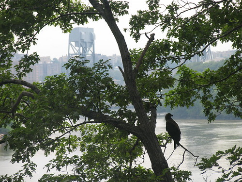
  • PLANYC2030 website
  • The Economist: The new New York
  • Streetsblog: Futurama 2030

  • Monday, August 21, 2006

    haliaeetus leucocephalus

    Some photos of Inwood's bald eagles (click to enlarge). One bird has already crossed the Hudson and is headed north; the others are expected to follow soon.


    A bald eagle perched above the Harlem River in Manhattan. The Broadway Bridge and the Bronx are in the background.


    An eagle in flight over the tidal basin.


    This is one of the birds "branching" a few weeks ago. Before they're able to really fly, bald eagles typically spend a few weeks hopping around branches and getting a feel for how their wings work.