Showing posts with label watersheds. Show all posts

Thursday, February 28, 2013

The Chase Manhattan Bank of Cholera

You probably know that Aaron Burr murdered Alexander Hamilton in a duel. But I recently learned of Burr's surprising and grotesque role in some of New York City's worst plagues — including one we're still suffering through to this day.

My dad recently gave me a fascinating (but not online, unfortunately) medical history of New York City's water supply by Dr. David E. Gerber, from which I learned this:
"In 1799, New York City passed on the responsibility of constructing and maintaining a waterworks to the newly charted Manhattan Company. The company, the brainchild of the improbable team of Alexander Hamilton and Aaron Burr, received from the state legislature a mandate to supply New York City with 'pure and wholesome' water."

Left: Manhattan Company log pipes excavated in 2004 near Coenties Slip. Via New York City Walk (photographer unknown)

But the Manhattan Company was terrible at providing "pure and wholesome water." They employed cheap wooden pipes and instead of procuring fresh Bronx River water, as had been proposed by city officials, they dug wells on the outskirts of the growing city (near today's Greenwich Village) where the water supply quickly became polluted with the city's sewage, or dried up altogether from overuse.

So in spite of a $2 million charter from New York's state government, the growing city continuted to suffer from polluted water. In 1832, the very first year that cholera arrived in New York City (from Asia, via overseas trade), 3,515 New Yorkers died.

There was a reason why the Manhattan Company was so negligently, fatally incompetent at its purpose: it was run by some of the city's earliest investment bankers, including the murderer Aaron Burr.

At Burr's initiative, the Manhattan Company's charter was amended shortly before it took effect to allow the new company to spend its excess capital "in any way not inconsistent with the Constitution and laws of the United States."

The Legislature and Burr's business partner, Alexander Hamilton, seemed to believe that this would allow for additional, future waterworks. But Burr almost immediately exercised this clause to capitalize a new bank, using the money intended for waterworks to give out loans to New York merchants.

The Bowery Boys, the New York history podcasters, have an episode on the Croton Aqueduct that tells some of this same story, and they put it this way:
"There was a banking monopoly where you had the US Federal Bank [i.e., Alexander Hamilton's First Bank of the United States] and the Bank of New York, which was founded by Hamilton, Burr's rival and victim. Burr and his company got a $2 million contract from the state legislature to bring fresh water into New York City.

They decided to spend it thusly: $100,000 on waterworks and bringing fresh water into the city — so 1/20th of the total — and $1.9 million on creating a bank!"

Providing "pure and wholesome water" was just a distracting sideline. In fact, the more the Manhattan Company spent on public waterworks (there were no water meters back then, thus no reliable user-fee system, thus no profit motive), the less they had to spend on high-interest loans to New York City's merchant class.

Hamilton evidently didn't like the competition from a new bank in town: he left the Manhattan Company shortly after Burr capitalized his new bank with 1.9 million New York State taxpayer dollars.

The citizens of New York suffered the Manhattan Company's filthy water until 1842,  when the City of New York finally opened an aqueduct from the Croton River, which provided public drinking water that was genuinely pure and wholesome, and does so to this day.

So New York eventually addressed its sanitation problems and cured its epidemics of cholera and yellow fever.

Unfortunately, Aaron Burr was only an early vector in New York City's raging plague of assholes who collect millions of dollars from the government in order to enrich themselves in the global banking casino.

In 1955, Aaron Burr's Bank of the Manhattan Company merged with the Chase National Bank to become Chase Manhattan. And in 2000, Chase Manhattan bought out the investment firm JP Morgan to become JP Morgan Chase, on whose website you can today download a short history that tells part of this very same story. This document includes some pictures of old wooden pipes and a quaintly threatening engraving (below) of their company's founding chief executive ballistically perforating the Founding Father on our $10 bill.

However, somehow JP Morgan Chase's PR department neglected to mention the part about all the cholera — hopefully they'll appreciate this addendum.


Monday, October 29, 2012

Buried Wetlands Rise from the Grave

This evening, Hurricane Sandy's storm surge will combine with astronomical high tides to give eastern seaboard cities an exciting preview of sea level rise. Forecasters are predicting storm surges up to 10 feet above the average high water mark — especially in western Long Island Sound and New York Harbor, where the storm is funneling massive volumes of seawater into the right-angled corner formed by New Jersey and Connecticut.

As I wrote last week in Grist, most big cities have buried their wetlands and creeks underground. But big storms and flood events like this one have a way of making those hidden waterways reassert themselves, as underground sewers and stormwater channels fill up beyond their design capacity and overflow into the streets above.

That can happen in unexpected places. Here in Portland it wasn't even particularly stormy today, and there was only light rain. But the astronomical high tide did push water up to the surface of Somerset Street, four blocks away from Back Cove (note the empty tree wells — similar events killed the street trees planted here in 2006 due to salt water in the roots).

Meanwhile, in Philadelphia, heavy rains may once again cause problems in the sewer-bound Mill Creek.

And in New York City's Boerum Hill and Park Slope neighborhoods, the old marshes of the Gowanus Canal may once again take over the streets. This overlay of the Brooklyn section of the 1782 British Headquarters Map shows (roughly) how far the old marshes of the Gowanus used to extend across central Brooklyn:

Wednesday, October 24, 2012

On Grist.org: "Sewer Discretion is Advised"

I've just published a new film review on the environmental news site grist.org about two new documentaries that profile the new watersheds. Here's an excerpt:

Most urban streams and creeks are hidden from sight — in huge sewer tunnels under streets and expressways, in concrete ditches behind razor-wire fences, and sometimes even in pipes under the manicured lawns and gardens of city parks.

These are hardly the kinds of places you’d see on the cover of an L.L. Bean catalog — although you might find a few L.L. Bean catalogs in these concrete creeks.

But a growing network of urban explorers, who sometimes call themselves “drainers,” are sneaking into the storm sewers and aqueducts to rediscover these long-hidden waterways. They’re finding lush forest groves among the concrete ditches and waterfalls and grand vaulted grottoes in underground sewers. Their photography and field notes remind residents that the rivers and streams that nursed their cities’ early growth still survive below the pavement, and are still worthy of appreciation — maybe even restoration.

Now, not one, but two new documentary films follow this small subculture of urban river enthusiasts, and celebrate the outsized impact of their civilly disobedient urban river expeditions.
Read the rest at grist.org.

Thursday, August 02, 2012

L.A. River series on Grist

This week, Grist is running a 4-part series I wrote about the Los Angeles River, based on my trip to L.A. earlier in July. You can read it starting here, with the introduction.

And though Grist was very generous with room to write, there were still lots of fascinating details that I had to leave out of the narrative. I hope to cover some of those stories here in the weeks to come. So if you've just found this blog, please consider subscribing to my RSS feed or following me on Twitter (@vigorousnorth). Also, feel free to send me an email if you'd like to share an interesting story that I missed: the address is c.neal.milneil at gmail dot com.

The Los Angeles River has more than enough stories to fill a book. If you're a publisher, please get in touch!

Tuesday, March 13, 2012

A Relic from the Gold Rush Space Program

A couple years ago I wrote about the Mannahatta project, an effort to reconstruct the pre-colonial ecosystems that existed on Manhattan Island, and the gorgeous computer-generated birds-eye-views that it produced.

Now, a Californian geographer named Mark Clark has made a similar speculative map, showing most of California as it might have looked from space in 1850 (via the Strange Maps blog):

What's most striking to me is how edenic the Central Valley looks with its original rivers and marshes streaming snowmelt from the Sierra Nevada into the lush swirl of marshes in the Sacramento-San Joaquin delta in the north, or, in the south, into the long-lost Tulare Lake, once the largest freshwater body west of the Great Lakes.

Now, the same landscape is all massive monoculture farm fields spotted with dusty, heat-blasted cities like Bakersfield and Fresno. Even more remarkable is that most of the transformation happened within a single generation during the early 20th century. Why aren't there more Hollywood blockbusters about this story?

And speaking of native Californian hydrology, a friend recently turned me onto the L.A. Creek Freak blog, which is all about trying to restore watersheds and their ecological functions in the Los Angeles metro area. I'm actually planning a visit to southern California early this summer — if any Californian readers want to leave tourism suggestions in the comments, or just say "hello," it would make my day.

Monday, January 30, 2012

The Drone Surveillance Agents of the Amateur E.P.A.

"And the third angel poured out his vial on the rivers and fountains of waters; and they became blood." - Revelation 16:4


In Dallas, an amateur drone hobbyist, flying his homemade surveillance rig around the skies of Oak Cliff, recently noticed something strange about the hue of Cedar Creek, which flows into the Trinity River just upstream of the city's showcase new kayaking park.


The amateur surveillance agent submitted his photographic evidence to the Texas Commission on Environmental Quality, which discovered an underground pipe from a nearby pork slaughterhouse that was sloughing volumes of pig blood and other slaughterhouse wastes directly into the stream. The slaughterhouse now faces serious criminal charges while the residents of the Trinity River watershed cope with their nausea (the Trinity watershed doesn't merely encompass greater Dallas; it also empties into Galveston Bay on the outskirts of Houston, which means the shrimp I ate last month might have included a few nanograms of diluted pig blood or the various pathogens that feed on it).

I have to wonder how long this was going on: the photo above shows how egregiously bloody the stream was, and it was happening within the inner neighborhoods of a huge city. Why did it take a hobbyist's flying machine to notice that something terrible was going on in Cedar Creek? Why didn't any of the millions of gravity-bound residents of Dallas think to ask why the river was running red — or did any of them even notice?

Maybe nobody had ever thought to look at the creek before this. Maybe, running through the middle of a city of millions of people, the creek had managed to surround itself in enough urban camouflage — industrial warehouses and power lines and cyclone fencing and weed-choked empty lots — to become completely anonymous, a secret hidden in plain sight.

Maybe the camera on a flying drone and a hobbyist's enthusiasm provided the first opportunity in years for a Dallas resident to peer into Cedar Creek without disregarding it as a short-lived streak of weeds seen peripherally through the car window at 40 miles per hour.

[as seen on the Field and Stream Conservationist blog, and at grist.org]

Monday, June 20, 2011

Where not to go swimming in Casco Bay

Tonight, Portland's City Council will vote on a 25-year plan to reduce the amount of sewage that gets dumped into Casco Bay during wet weather.


The green warning signs like the one pictured above (located next to the city's cruise ship dock) mark the locations of Portland's combined sewer overflow outlets. During wet weather, when millions of gallons of rainwater flow into storm drains and overwhelm sewer pipes, these outlets keep sewerage from backing up into the streets, by dumping it into local waterways instead (read all the details here).

These combined sewer outlets can be found in surprising places: there are three in the heart of the Old Port, the city's tourism district, including one right next to the outdoor dining area of the Portland Lobster Company, another at the busy ferry terminal, and a third next to the city's cruise ship berth. Along with a few more further down the waterfront, these outlets collectively dump 145 million gallons of sewage into Portland Harbor in a typical year.

Seventeen more outlets ringing Baxter Boulevard, a popular city park, dump over 400 million gallons of mixed sewage into the shallow, stagnant waters of Back Cove. By way of comparison, last year's BP oil spill in the Gulf of Mexico dumped about 210 million gallons of oil into the Gulf.

Nearly twenty years into the city's efforts to separate storm drains from toilet flushings, the city has managed to shut down ten CSO outlets, including the one located nearest to the city's East End Beach, as well as most of the outlets that had dumped into Capisic Brook in the city's western suburbs. But dozens of overflow outlets still remain. The map below shows where they all are (the handful of star icons represent former outlets that have been closed):


As disgusting as this problem is, solving it won't be cheap, quick, or easy. The City is looking at a range of strategies, from building new green infastructure that can absorb rainwater into the ground before it flows into storm drains, to building huge underground storage tanks that can expand the system's capacity to hold sewage without spewing it out into the harbor.

Altogether, the recommended projects will cost the city $170 million - about $2,500 for every individual resident of the city - over the course of 25 years. That would roughly double our sewer bills, and not even then would we have a sewer system that avoids dumping sewage into Casco Bay altogether (the engineers estimate that we'd still dump 87 million gallons a year, an 88% reduction over current levels).

A fair and effective way to pay this bill would ask property owners who contribute the most to the city's sewer overflows to pay a greater share, by charging a fee in proportion to the amount of sewage and stormwater their properties send into the pipes. A one-inch rainstorm on an acre of pavement sends 26,000 gallons of oil-soaked stormwater (the equivalent of 15,000 toilet flushes) down the drains, so the owner of a large parking lot ought to pay substantially more to fix our sewers than an apartment dweller or a homeowner with a rain-absorbing garden.

This wouldn't just be a fairer way to pay for the city's sewer upgrades - it would also encourage property owners to make their own small efforts to help relieve the amount of stormwater flowing into our sewers, whether by tearing up some pavement to install a rain garden, or by fitting in more housing units on smaller lots. Small efforts multiplied thousands of times across the city's watersheds could substantially reduce the impacts of Portland's sewer problems, and the costs of fixing them.

Thursday, March 03, 2011

Glaciers at risk!

It's that time of year again when hundreds of truck-loads of snow get dumped near the bottom of Chestnut Street to form the Bayside Glacier (documented previously here, here, and here).

In last week's Portland Phoenix, I wrote a short follow-up piece about recent legislation that proposes to dump these icebergs of sewage directly into rivers and harbors.

PS - It's bullshit like this that has kept me from blogging much lately. Elections have consequences.

Thursday, October 28, 2010

Marble Hill in Manhattan (not the Bronx)

I recently discovered* Pathological Geomorphology, where various geobloggers share "images of extreme landscapes, landforms, and processes," organized around a monthly theme. Last month was dedicated to landslides, for instance. This month: "the juxtaposition (or superposition) of distinctly human-made landscapes with nature's geomorphic forms."

This immediately reminded me of Marble Hill, a neighborhood in the borough of Manhattan that is physically attached to the Bronx. Here's an aerial view - to orient you, this is the Harlem River ship canal where it curves around the northern tip of Manhattan. A small corner of the Hudson River is in the upper-left corner, and Broadway, and the West Side IRT subway lines, run diagonally from the middle of the bottom edge to the upper right-hand corner:


You can clearly see a looping s-curve through the middle of the picture. It's the old course of the Spuyten Duyvil Creek, which was widened and straightened in the nineteenth century for use as a ship canal between the Harlem and Hudson Rivers. On the left side of the photo is Inwood Hill Park, where I worked as an urban park ranger in 2005. The old creek is still more or less a waterway there, though it's been filled in substantially. The nature center and baseball field at the northeastern entrance of the park (the small peninsula left of center in the photo above) actually used to be connected to the Bronx.

The eastern loop is more interesting. It's been completely filled in - parking lots, warehouses, and big box stores now occupying the former creek bed. But the streets still trace the lines of the historic creek banks. The neighborhood between the new ship canal and the old creek bed is called Marble Hill. It was attached to Manhattan Island until 1895, when the ship canal sliced it off and marooned it as an island. Here's a map from that turn-of-the-century period, via Forgotten New York:


The creek was filled in 1917 to attach Marble Hill to the mainland of the Bronx, but the neighborhood, for political and judicial purposes, remained in New York County, and the borough of Manhattan.

I've heard, anecdotally, that a number of Marble Hill residents still insist on snubbing the borough that surrounds them by telling people they live in Manhattan, which sounds more upscale than the Bronx. So, while the historic geomorphology of the former Spuyten Duyvil Creek does survive to this day in a ghost-pattern of street layouts and land uses, it survives in a more tangible sense in the neighborhood's civic affairs and a general sense of inter-borough snootiness.

Of course, this is probably my best example of how ancient geomorphic forms have influenced human-made landscapes - but I've already written about that one.


*via mammoth, another blog I've discovered and really come to enjoy in the last couple of months - it writes extensively about urban infrastructure and how it relates to our economy and ecologies. If you like this blog, you'll enjoy theirs, too.

Tuesday, August 17, 2010

The Great Plastic Migration

This nature documentary about the trans-oceanic migrations of plastic bags is making the rounds today. The Californian nonprofit Heal the Bay is promoting the video as a means to rally support Assembly Bill 1998, which proposes to ban single-use plastic bags at California shops.


Note the appearance of the Los Angeles River around 2:20.

Though tongue-in-cheek, I would love to see more nature documentaries like this one. How about an episode about the larval stages of plastic bags, from the oil refinery to the grocery store?

Anyway, it's one thing to zoomorphize plastic bags. Why not anthropomorphize them as well - let them carry a human personality as they drift through the wind, freed from their more material cargo? This personality would necessarily need to have mixed feelings about its immortality - simultaneously self-important and lonely. And it would also have to feel a deep bitterness about its lack of agency, and resentment for the external natural forces that dictate its fate.

If you're saying to yourself, "Hey, that sounds a bit like Werner Herzog," you're in luck! He's precisely the man who narrates the thoughts of a lonely plastic bag in this video by director Ramin Bahrani:


After a tedious journey, Herzog the bag ends up in the Pacific Ocean as well, not particularly fulfilled by its migration, and somewhat bitter at its own failure to die.

Tuesday, March 09, 2010

Intermission Floods

Early last year I wrote a post about the sudden spikes in demand for electricity that happen nightly in Britain, when millions of Britons put on their teakettles at the conclusion of the soap opera Eastenders. A lone engineer sitting in a high-tech control room watches the program with the rest of the nation, and as soon as the credits roll, he opens the floodgates through dozens of European hydroelectric dams in order to deliver enough electricity.

It's a deluge equivalent to ten Niagara-sized waterfalls set loose for fifteen minutes every evening. On the surface, it's hard to see any connection between a cultural predilection for hot beverages, a television drama, and the ecosystems of European rivers. But it's certainly there - unfortunately, most Brits are too busy making tea to notice the hydrologic spectacle that their utility bills are paying for.

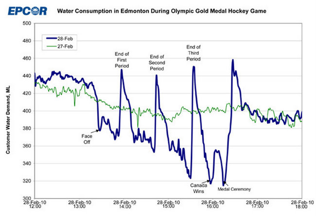
The big gold-medal hockey game between Canada and the United States provided another striking example of how a cultural phenomenon can set loose Biblical floods through the pipes of our modern infrastructure. EPCOR, the water utility in Edmonton, Alberta, recently published this chart of water consumption during the big game, which two-thirds of Canadians were watching (graph courtesy of Pat's Papers):

The scale of the y-axis is in megaliters, which means that between the final seconds of the third period and the pre-overtime intermission, water consumption spiked by 140 million liters, or 37 million US gallons - roughly the amount of water that flows over Niagara Falls in a two-minute interval. During the span of one commercial break, this water flowed from huge city reservoirs, through arteries of water mains and millions of bathroom pipe capillaries, then out through another mesh of pipes, into Edmonton's sewer system.

How's that for a natural wonder? Unfortunately, most Canadians missed the opportunity to witness it in person - they were locked in their bathrooms instead.

Thursday, August 27, 2009

The Aral Sea Is Gone

Via NASA's Earth Observatory, an image of the (former) Aral Sea, this August:


Near the dry harbor of Aral, Kazakhstan. Via Wikipedia.
The Aral Sea used to straddle the border between Uzbekistan and Kakakhstan as the world's fourth-largest saltwater lake. A Soviet industrialization program in the 1940s diverted most of its source water to irrigation projects for thirsty cotton farms in the desert. By the 1960s, most of the sea's water supplies had been diverted, and it began to shrink.

As the sea evaporated, a new desert, known locally as the Aralkum, took its place. The desert's soils consist of fine marine deposits mixed with highly polluted runoff from the former industrial cotton farms that used to surround it. Massive dust storms have blown this soil and its pollutants all over the world. The disappearance of the Sea has also removed a tempering influence on the regional climate: winters are now colder, summers are hotter, and there's less rainfall. Ironically, these problems haven't helped the industrial cotton farms that continue to divert water from the former sea's source rivers.


The Aral Sea seen from space in 1985. Via Wikipedia.
At the same time, as the lake shrank, its waters became increasingly saline. The water that remains in the disappearing southern lagoon is now three times saltier than typical ocean water.

The Kazakh government has undertaken a number of projects to restore the northern part of the sea, where water levels have recently stabilized and a fishing industry has even been able to re-establish itself. But the much larger southern portion has been written off as a lost cause, and continues to shrink at rapid rates.

Pretty amazing: in roughly half a century, a sea that was once the size of Missouri has essentially disappeared.

So long, Aral Sea.
We hardly knew ye.

Monday, August 24, 2009

A Field Guide to North American Seafood Menus


The Monterey Bay Aquarium has put together a consumers' guide to sustainable seafoods. The idea is to encourage grocery shoppers and restaurant patrons to support responsible fisheries, like wild Alaskan salmon, and to avoid fisheries that are environmentally harmful or near collapse, like farm-raised Atlantic salmon.

Snapper, Red

Rating: Avoid


Red snapper is in decline worldwide, and fishing pressure on this species remains excessive. Red snapper should therefore be avoided.

Market Names:
Mule Sow, Rat, Tai, American Red Snapper
The guides started as printable pocket versions that you could fold into your wallet and consult at the supermarket. But now there's an even better, more discreet version for mobile phones, accessible at mobile.seafoodwatch.org (part of the mobile-phone webpage about Red Snapper, a species that's in serious decline, is shown at right). Or, if you prefer, get the iPhone app. There's even a guide tailored for sushi restaurants that translates common Japanese fish names.

These guides are meant to accompany your menu at the restaurant, but I find them pretty fascinating in their own right. For instance, the Aquarium's guide for the Northeast region endorses Pacific halibut as "best choices," but we're advised to "avoid" Atlantic halibut and flounder caught here in the Gulf of Maine.

Clams (both farmed clams and wild steamers) are also endorsed as a "best choice." Which is good news, as long there's no red tide.

And Monterey is lukewarm about Maine lobster, a fishery that's long been hailed for its socially-driven sustainable management techniques. Maine lobster ranks as merely as a "good alternative," not as one of the "best choices," since the "current population status is considered weak or unknown" and there are concerns about right whales getting trapped in the buoys and lines attached to traps. Haddock also falls into the middling "good alternatives" category, with the caveat that "the majority of U.S. Atlantic haddock is caught using bottom trawl gear [which causes] considerable habitat damage to seafloor habitats."

So maybe I'll switch my preferred clam-shack order from fried haddock with tartar sauce to fried clams, and just opt for salad during red tides or after big rainstorms.

If you're a chef looking for sustainable-fisheries cred, Monterey Bay and a number of other marine research institutions also recently launched fishchoice.com, a tool for restaurants and other commercial seafood buyers.

Wednesday, June 24, 2009

Heavy rains and the fecal ocean

A public health advisory:

In the past week, most of the northeastern Atlantic seaboard has received several inches of rain. The storm drains and sewers of the region's cities have been overwhelmed by millions of gallons of runoff, carrying whatever garbage was lying in the gutters and frequently discharging a mix of raw sewage and street runoff in older cities' combined sewer systems.

So (and I'm sorry to be such a bummer), even though it's finally sunny and warm, it would be kind of gross to take a dip in the ocean right now.

Here in Portland, for instance, the East End Beach has been under a pollution advisory for most of the past week, and was closed completely over the weekend. In New York, several beaches in the Bronx and North Queens are under advisory or closed, and a number of beaches around Boston in Massachusetts Bay are either closed or nearing the health limit.

Beach water quality is determined by the number of enterococci bacteria found in a 100 milliliter sample, which is highly correlated with the number of other pathogenic bacteria that are often found in sewage, including fecal coliform. The federal limit defined by the EPA is 35 colonies per 100 mL, but keep in mind that the federal standard has been influenced by lobbyists: Hawaii, the state with the strictest water-quality standards, posts warnings on its beaches if its testing samples find any more than 7 bacteria in 100 ml of water.

So, for instance, you might not want to swim at Boston's Carson Beach, even though its open, since the sample taken yesterday found 31 colony-forming units of enterococci. Scarborough Beach State Park found 20 colony-forming bacteria in its sample on Tuesday. And even in relatively isolated areas of the coast, weird stuff is washing up on beaches - for instance, dozens of used hypodermic needles on a beach in Harpswell, in midcoast Maine.

So, as tempting as it is, I will not be visiting a beach this afternoon. If I were you, I'd lay off the bottom-feeding bivalves and crustaceans for a week or two as well. Luckily, the ocean is good at washing itself out with several tides every day, and if the dry weather continues I might take a dip this weekend.

Here are the public health websites where you can read up on bacteria counts and beach advisories for the Northeast's major cities:

Maine Healthy Beaches
Massachusetts Bureau of Environmental Health
New York City Beach Quality Reports
New Jersey Ocean Beach Information - NJbeaches.org

Wednesday, May 13, 2009

Premium/Flavored/Enhanced

Via Planet Money.

The American economy has taken some hard knocks lately, but at least it's still able to quench our thirst for getting mind-fucked with an overwhelming array of meaningless choices.

And now, please enjoy this advertisement:

Monday, April 13, 2009

Return to Inwood Hill Park

Last weekend, a friend of mine recruited me to come down to NYC to lead a nature walk for some sixth-graders from Washington Heights. So I brought them to my old park-rangering haunt, Inwood Hill Park, for my first visit back there in almost three years (n.b.: my experience as an Urban Park Ranger at Inwood is more or less how this blog was born).

We walked up the hill through the old-growth woods in the Clove, climbed through the Indian caves, and we saw:
  • the red-tailed hawk
  • several cardinals
  • a downy woodpecker
  • lots of house sparrows and squirrels
It's hard to tell what the kids thought of it. They were very well behaved, but then, they were also attending a Saturday-morning educational program on their own free will. They definitely liked the caves, though, and they seemed to think that the cardinals were neat. I wish we could have seen the hawk attack a pigeon or something: then the kids definitely would have loved nature, forever.

Anyhow, the park is much as I remember it, although it feels much smaller without any leaves on the trees. There was one very exciting change, though. A crescent-shaped piece of the playing field next to the "salt marsh" (pictured above) has been fenced off, with signs announcing the following:
RESTORATION IN PROGRESS: This area is being passively restored to native salt marsh. Sensitive vegetation, including Salt Marsh Cordgrass (spartina alternafolia), is in the process of regenerating.
This is pretty exciting. Before it was filled in with gravel and debris from the subway excavations, this entire field had been an expansive, ecologically-rich salt marsh. Large oyster-shell middens in the park's woods attest that the marsh helped support, among other things, one of the Hudson estuary's more productive oyster beds in the adjacent Spuyten Duyvil Creek. In the decades since, the adjacent mudflat (which park personnel optimistically refer to as the "tidal marsh") hosted the last remnants of the old marsh around its fringes, but even these sad shreds were sorely abused with picnic garbage, combined-sewer overflows, and park workers who hacked the marsh plants down with machetes for unclear "safety" purposes.

It's funny how often "safety" gives pencilneck bureaucrats the fiat to act like dicks.

In recent years, the edges of the filled-in playing field have been sinking, as the decades-old landfill settles and as tides from the adjacent mudflats gradually rise higher. When I worked there in 2006, there were two big London Plane trees on this location. During the course of the summer, their leaves dried up and fell, as the trees' roots parched themselves on increasingly briny groundwater. Instead of adding new landfill and planting new trees, the Parks Department has decided to let it sink: a decision that will be a lot cheaper and do a lot more good to the Spuyten Duyvil's water quality.

Wednesday, April 08, 2009

More Glaciers of Portland

Belatedly fulfilling my promise of more glacier photos...


The Fore River Glacier.
Just like other glaciers in the wild, the Fore River Glacier possesses an alluvial fan pattern that spreads out as it approaches the water.


The Bayside Glacier.
It's only a fraction of a size of last year's glacier, thanks to a planned office building and parking garage that was due to begin construction this spring. The construction project has been canceled due to the financial crisis. As long that the same crisis doesn't also cancel the city's Public Works Department, we can look forward to a Bayside Glacier returned to its former glory next winter.


The Sable Oaks Glacier.
A view from the summit of the city's main snow dump. More Sable Oaks Glacier photos here.

Wednesday, March 25, 2009

The Sable Oaks Glacier

Above: the mighty Sable Oaks Glacier, the final resting place of most of Portland's plowed snow and all the street grime and garbage that was buried beneath it during the past winter's snow storms.

The Sable Oaks Glacier is the city's main "snow dump," a larger version of the Bayside Glacier that has showed up downtown in the past couple of years. I've written about the city's glaciers previously on this blog (here and here), and in a feature for the Portland Phoenix last spring, but this was my first visit to the big one.

I visited this natural wonder this evening right before sunset. It's a time we scenic nature photographers call "the magic hour," because of the magical way the light dances across the filthy, shit-streaked snow.


The Glacier is out by the airport, past the overflow parking lot, at the city's public works yard. There are nice views and these photos can't convey the scale of this thing. I highly recommend visiting. More photos to come tomorrow.

Thursday, February 19, 2009

The untreated sewage of Canis familiaris

Every year around this time, the melting snow and ice reveals hundreds of turds that lazy dog owners have left behind over the course of the winter. It's disgusting and infuriating: why do people see fit to turn our streets and sidewalks into open sewers?

If you read this blog, you know where the street shit is destined: it'll wash down a storm drain, and into the nearest river or harbor. In many cities, domesticated dogs are a significant source of fecal coliform bacteria in urban waterways and beaches. For those of us who live next to Casco Bay in Portland Maine, all that water-borne fecal bacteria will be absorbed and filtered by the bivalves and bottom-feeding crustaceans that are beloved to gourmands. Although maybe a bit less so, now.

According to the EPA, "Pets, particularly dogs, are significant contributors to source water contamination. Studies performed on watersheds in the Seattle, Washington, area found that nearly 20 percent of the bacteria found in water samples were matched with dogs as the host animals." A 2002 USA Today article summarized more research about the problem:
"The environmental impact of dog waste went unrecognized for decades. Then scientists developed lab techniques to determine the origin of fecal bacteria contaminating water... At Morro Bay, Calif., for example, dogs contribute roughly 10% of the E. coli, says Christopher Kitts, a microbiologist at California Polytechnic State University-San Luis Obispo. "And that can be the difference between a beach closing and a beach not closing," he says."
Let's be perfectly clear about this: if you're not picking up after your dog, you're essentially dumping untreated sewage into the nearest stream, lake, or ocean.

Monday, January 26, 2009

The teatime deluge: how a British soap opera sets loose ten Niagara-sized waterfalls every evening

Writing this blog, I'm regularly astounded by the interconnectedness of our post-industrial global economy - a system whose intricate complexities rivals those studied by biologists in wild ecosystems.

Our economy and our global ecosystem aren't just similarly complex - they're intimately related and reliant on each other. This fact riles traditional environmentalists, who lament mankind's peculiar niche, but trying to deny it would require denying that humans live on Earth. We can't understand how nature works without understanding how our economy works. Nor can anyone claim to understand how our economy works without also understanding how our ecosystems work.

For an elegant demonstration of this fact, consider this clip from the BBC, which explains what happens to Britain's electric grid and watersheds as soon as the credits roll on a popular soap opera every evening:


In order to manage the electrical demands of a million tea kettles being turned on at once, then, British utility managers unleash a nightly deluge from reservoirs all over the island. Hundreds of billions of gallons of water are set loose to fall through hydroelectric turbines: it's roughly the equivalent of ten Niagara-sized waterfalls turned on for a few minutes while the tea boils (see the footnote for the math and some mind-boggling numbers).

Ten Niagaras synchronized with the end-credits of the BBC's most popular soap opera: how's that for a spectacle of nature? Doesn't this phenomenon deserve its own national park? Or at least a highway rest stop?

Instead, it's mostly ignored and taken for granted. Even the engineer in this clip seems blithely indifferent to the deluge he's setting loose: entire lakes are reduced to buttons on a spreadsheet at his desk. A power delivery from France fails, but a few clicks and another lake empties out, no big deal.

We might be prone to dismiss this force of nature because it's manmade, but that's precisely the reason we ought to be paying attention to it. Dams, after all, can inflict serious harm on watersheds and fisheries; maybe Britain would need fewer of them if more people were aware of the teatime deluge, and made their own efforts to reschedule their kettle use.

At the very least, knowing that the hydrological equivalent of Moses's Red Sea miracle was being put into the daily service of their tea kettles might lead Britain's soap opera audience to feel more humility and respect towards the natural resources they use, wittingly or not, every day.


* The physics: producing 3 gigawatts of electricity for a fifteen minute period is equivalent to 0.75 gigawatts of work, or 2.7 trillion joules. That amount of energy requires the equivalent of over 700 billion gallons of water (or 2.8 trillion kilograms) falling 100 meters through dams: 2.8 trillion kg * 9.8 m/s2 * 100 m = 2.74 trillion joules.

Niagara Falls is 53 meters tall and pours 150,000 gallons per second, or 135 million gallons in a 15 minute interval. 135 million gallons weighs 511 million kg, so Niagara's water produces 53 m * 511 million kg * 9.8 m/s2 = 265.4 billion joules, or 73.72 megawatt hours of (unharnessed) energy.