Showing posts with label astronomy. Show all posts

Friday, January 27, 2012

The Whole Earth 2012: Snowless and Drought-Ridden

Yesterday, NASA released a composite photo of the "Whole Earth" as seen from space, like the ones taken by Apollo astronauts of the 1970s. This one was taken on January 4, 2012 (around 4 pm Eastern time, by the looks of it - you can just barely see New England in the upper right corner passing the horizon into the winter nighttime).


Source: NASA (click for the large version)

It's a stunning image, without a doubt. And it got lots of attention yesterday on Twitter and on various blogs.

But the most relevant insights, I think, came from Dr. Jeff Masters at the Weather Underground blog:
The image is very interesting meteorologically, and extremely strange. It is obvious that it is a winter image, as revealed by the large area of stratocumulus clouds off the U.S. East Coast all the way to South Florida, caused by cold Canadian air blowing offshore. However, the U.S. and Canada are virtually snow-free and cloud-free, which is extremely rare for a January day. The lack of snow in the mountains of the Western U.S. is particularly unusual. I doubt one could find a January day this cloud-free with so little snow on the ground throughout the entire satellite record, going back to the early 1960s.
Such is the Earth in 2012: baked and drought-ridden.

Monday, August 01, 2011

Back to the land... in outer space!

The peak of the American suburban impulse may well have been the year 1975, the year a group of earnest technocrats and back-to-the-land hippies converged to make the case for orbiting shopping plazas and ranch-style homes in deep space.

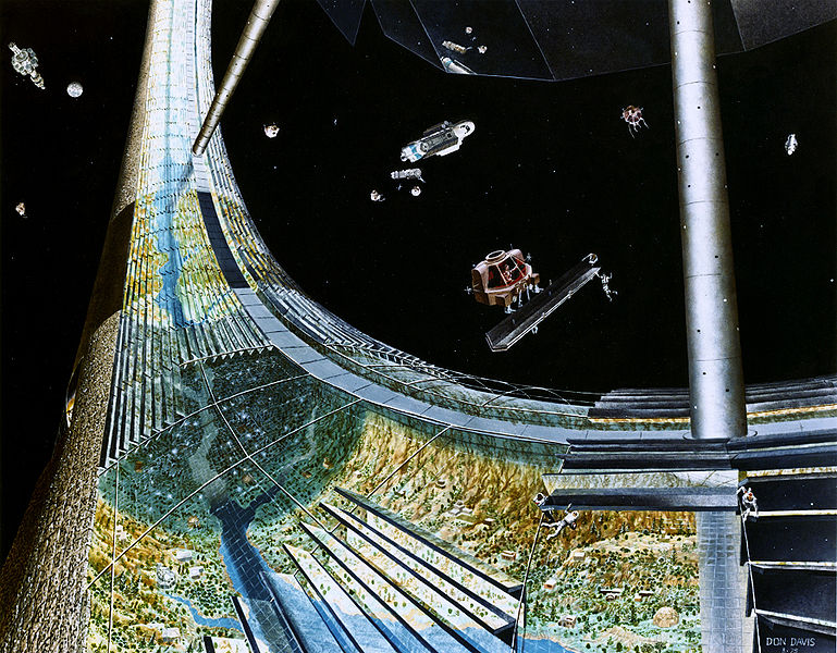
When I was a kid obsessed with astronomy, I spent hours staring at paintings by Don Davis, an American artist best known for his sci-fi illustrations. The works that I remember most vividly were his depictions of the space colonies advocated by Princeton physicist Gerard O'Neill in the mid-1970s, which were brought to my attention recently by a recent blog post on The Atlantic's technology blog.


These paintings were, and still are, utterly bewildering. To simulate gravity by centrifugal force, the theoretical colonies generally had a cyclindrical or toroidal design, which meant that landscapes didn't recede to a vanishing point on a horizon, but instead curved up and overhead. Meanwhile, mirrors and shades on the exterior controlled night and day cycles, and blended scenes of clouds with the starry dark of deep space. All in all, trying to figure out the logic of perspective in these paintings is like puzzling through a complicated Escher print.


But even weirder than all that were the pastoral scenes depicted, floating around in tubes through the vacuum of space. The picture above was intended to simulate the northern Californian coast, according to an autobiographical statement on Davis's website:
"It was painted this way under the direction of Gerard O'Neill himself, who related a recent impression of the vantage point from Sausalito being an excellent scale reference for a possible setting inside a later model cylindrical colony... I deliberately wanted to imply the challenge of trying to transplant a workable ecosystem to a giant terrarium in Space."
Many of these paintings came out of a NASA-sponsored summer camp for space theorists held at Ames research center in 1975. In that same year, Stewart Brand, the creator of the Whole Earth Catalog, gave O'Neill several pages to make the case for space colonies in his new publication, the CoEvolution Quarterly.


It's easy to ridicule these space suburbs now, with the benefit of hindsight. In 1975, though, the brand-new Space Shuttle was being designed and promoted as our cargo utility truck to the heavens, and the idea of space colonies resonated with at least a few back-to-the-land hippies (like Stewart Brand) who dreamed of a new frontier in which to escape the Earthbound troubles of energy shortages, nuclear war, and the decline of American cities.

Big-name environmentalists of the era mostly ridiculed the idea of space colonies - but they still took the idea seriously enough to send in responses to the idea for Brand's magazine, something that would be hard to imagine today.

Some, like Buckminster Fuller and Carl Sagan, doubled down on their faith in high technology and fully endorsed the concept. But most of Stewart Brand's readers and contemporaries were more skeptical. Steve Baer, a designer of off-grid houses, had this critique, which reads like a purloined passage from J. G. Ballard or Don Delillo:
"I don't see the landscape of Carmel by the Sea as Gerard O'Neill suggests... Instead, I see acres of air-conditioned Greyhound bus interior, glinting slightly greasy railings, old rivet heads needing paint - I don't hear the surf at Carmel and smell the ocean - I hear piped music and smell chewing gum. I anticipate a continuous vague low-key "airplane fear."
And Gary Snyder, the beat poet who practiced Zen Buddhism in the rural suburbs of the Sierra Nevada foothills, bemusedly shrugs off Brand's enthusiasm:
"Thanks for the invitation to comment on O'Neill's space colony. I'm sure you already suspect that I consider such projects frivolous, in the all-purpose light of Occam's Razor my big question about such notions is "why bother?" when there are so many things that can and should be done right here on earth. Like Confucius said, 'Don't ask me about life after death, I don't understand enough about life yet.' Anyway. I'm hopelessly backwards, I'm stuck in the Pleistocene. That is, seriously... I'm still mucking around in the paleo-ethno botany, which is a kind of zazen."


While I agree with the substance of what Snyder and Baer say, I find their commentary ironic in light of the back-to-the-land lifestyles they practiced and advocated. Baer, after all, made his living by designing off-the-grid homes for communes like Drop City - space stations for the deserts of the southwest, in other words. And while I admire much of what Snyder wrote, I also regret that his political and environmental activism suffered from his self-imposed suburban exile in the Californian foothills. When he writes "there are so many things to be done right here on Earth," I want to shake him out of his meditation long enough to point out the racial and social iniquities in his own backyard.

In the end, isn't an idyllic sylvan landscape millions of miles away from the nearest city the logical extreme of the back-to-the-land movement that Baer, Snyder, and a million other Whole Earth Catalog readers dreamed of? Lewis Mumford, the famous champion of closely-knit urban neighborhoods, is a more reliable critic of space suburbs, and sure enough, his critique was the sharpest and most succinct of the bunch:
"I regard Space Colonies as another pathological manifestation of the culture that has spent all of its resources on expanding the nuclear means for exterminating the human race. Such proposals are only technological disguises for infantile fantasies."
Simply replace "Space Colonies" with "shopping centers" or "subprime mortgages", and it can still apply today in our post-space age.

Friday, July 08, 2011

End of the Space Age

The Space Shuttle Atlantis rides off into the sunset (photo from 2006, courtesy of NASA).

Two weeks before I was born, in April, 1981, the first Space Shuttle mission went into orbit over Cape Canaveral.

Now, thirty years later, the Space Shuttle will soon make its final landing, never to rise again. Earthbound, at the beginning of my thirties, I'm left with a strange feelings of nostalgia for my old childhood expectations of the twenty-first century.

I feel like I've outlived the future.


Thursday, December 02, 2010

The alien life in Mono Lake

NASA's astrobiologists have discovered a new form of life that uses arsenic, a toxic chemical, as a critical building block in its organic chemistry.

If you haven't read more about the discovery of arsenic-based life in California's Mono Lake, blog io9 has a great writeup of what it's all about, why it's such a big deal, and some of the implications - from the possibilities of new biofuels to the possibilities of life on Titan.

Alien life has been discovered right here on Earth. Nature is pretty incredible.

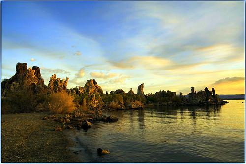
Mono Lake at sunrise, by John Muller.


Friday, February 12, 2010

Double Aurorae on Saturn

The planet Saturn takes thirty Earth-years to orbit the sun, which means that its equinoxes happen only once every fifteen years. One of those equinoxes happened last September, and astronomers took the opportunity to focus the Hubble telescope on the planet to photograph it with both poles visible at once, and equally illuminated by the sun. The result is this image, which shows two simultaneous aurorae (!) on the poles of the distant gas giant:


Hubble captured a series of images like this one to assemble a short film of the aurorae, which are helping scientists to better understand Saturn's magnetic fields. "Given the rarity of such an event," comments ScienceDaily, "this new footage will likely be the last and best equinox movie that Hubble captures of our planetary neighbour."

Saturday, December 26, 2009

Portlandhenge: Winter Street


These photos were taken the morning after the winter solstice - December 22nd at about 7:30 am - on Winter Street in Portland, Maine.

As you can see, the length of Portland's "Winter Street" is almost perfectly aligned with the rising sun on the winter solstice (as well as on the days immediately preceding and following).

Coincidence?

More on Portlandhenge, Manhattanhenge, and other city-henges here.

Tuesday, November 24, 2009

Archaeology of the Space Age

In the previous century, our ancestors went to the moon.

They left Earth in antique capsules perched on top of a million pounds of explosives - the largest rockets ever built.

They navigated with wristwatches, slide-rules, and primitive computers with less processing power than a basic cellphone.

And they took pictures. America's first unmanned satellites carried chemical darkrooms on board, where film was developed, translated into radio waves, and beamed back to Earth. On the ground, the satellites' analog photographic data was stored on magnetic tapes.

And then we forgot about them.

The original data for our earliest pictures of the moon, like the one at left, were very nearly lost - the tapes were filed away, and the machines necessary to translate them into images again were discarded as government surplus.

But a few years ago, a team of technological archaeologists, working in an abandoned McDonald's restaurant, recovered the tapes and painstakingly re-constructed the antique equipment required to translate their data into images.

The Apollo-era tape-readers themselves had been saved by a former NASA planetary phtographer, Nancy Evans, who stored several of the wardrobe-sized machines in her garage for decades in the hope that someone, someday, would want to recover the photos.

It's a pretty remarkable project - as though the complete journals of Sir Walter Raleigh had been found written in an obscure Elizabethan code, and the only way to translate the treasure were by refurbishing a heavy cabinet full of derelict gears and pulleys that someone had found in a cobwebbed dungeon of the Tower of London.


The archivists are working not in a museum, but in a defunct burger joint, with the tapes piled on the floor next to the grills, and a pirate flag hanging from the window. In this headquarters of the Lunar Orbiter Image Recovery Project (LOIRP), workers are rehabbing the old machinery with the goal of recovering and digitizing the old images in their original level of detail.

It's a digital archaeological expedition: recovering precious artifacts of the space age, using machines whose operations have been forgotten, in a fast-food ruin.

The Lunar Orbiter missions produced images of extremely fine detail in order to scout landing and exploration sites for the manned missions. In fact, one reason behind the restoration project is because they're still some of the most detailed images we have of the moon's surface, and NASA is interested in going back.

At the time, due to security concerns about revealing the capabilities of American satellites, the public only ever saw second-hand images - photographs of the original photographs. The LOIRP project will not only digitize these landmark images; they'll also make them available to the public for the first time in all their glory.


Above: crew sleeping quarters and tapes in the McDonald's kitchen. Each canister contains one photograph's worth of data. Photo by jurvetson on flickr.

Read more:

NASA: LOIRP images

KN6DJMJUJGFU

Friday, March 20, 2009

THIS WEEKEND: Portlandhenge, Chicagohenge, District of Columbiahenge, Houstonhenge...


Winter is nearly over! Today, March 20th, marks the spring equinox: here in the northern hemisphere, the sun will spend more time over the horizon than under it for the next six months.

Among other things, this means that for the next couple of days, the sun will rise almost exactly to the east, and set exactly to the west. Which, if you live in one of the hundreds of American cities whose street grid is oriented to the cardinal directions, your east-west streets will function as an urban Stonehenge this weekend.

I wrote about the Cityhenge phenomenon here back in September during the fall equinox, and in an article for the local alt-weekly, the Portland Phoenix. Quoting from the latter:
"On the National Mall, the Washington Monument casts its first shadow of the day over Lincoln’s statue, and then, 12 hours later, over the peak of the Capitol dome. In Houston, the setting sun is blinding commuters on the Katy Freeway. Throughout most of Chicago, people can watch the sun rise over Lake Michigan and set over the prairie."
If the skies are clear this weekend, head out to the nearest east-west street at sunset, and enjoy the view while celebrating some pagan astrological rituals. Portlanders: you'll find me outside the Soap Bubble (where I snapped the photo above last fall) this evening at sunset. See you there!

Friday, March 13, 2009

The Receding Tide of Winter

Up here in Maine, the days are getting longer and warmer, but the ground is still covered in deep snow. It happens every March: the calendar says it's spring, but the legacy of a four-month winter remains.

This animation from NASA's Earth Observatory shows the extent of snow cover in the Northern Hemisphere every month since February 2000. The gray disk in the center that appears, grows, and shrinks every winter is the extent of the Arctic's 24-hour darkness, which prevents NASA's satellite from collecting snow-cover data.


I love how this animation reveals the mountain ranges of the middle latitudes every winter: first the Rockies and the Alps, then the Caucasus, Appalachians, and Atlas ranges. The Ural Mountains lead the vanguard of winter snow from the Arctic Ocean towards the Caspian Sea. The snow is like an ebbing and flowing tide that hides and reveals islands of cold.

Click here for the original, more detailed animation from NASA.

Wednesday, September 24, 2008

Portlandhenge

As several commenters inferred, the photo in the last post demonstrates the "druidic/pagan significance" (as Turboglacier puts it) of several streets in Portland's West End. Due to their precise east-to-west alignments along the earth's lines of latitude, these streets - Bowdoin, Carroll, Pine, and the appropriately named West - function as an urban Stonehenge during the year's two equinoxes, when the sun rises due east and sets due west.

I've written more about the phenomenon in this week's Phoenix. That article talks a bit about how the Stonehenge effect repeats itself on different streets in Portland in different times of year. For instance, on the winter solstice, the sun rises roughly along the length of Winter Street, as well as Clark, Brackett, State, Park, and High Streets. Other streets, conforming to different grids in the city's neighborhoods, align along sunrises at other times of year, as the angle of the sunset and sunrise (also known as the azimuth) moves from the northern part of the horizon in summertime to the southern part of the horizon in winter.

But the phenomenon is by no means unique to Portland. At the equinoxes, no matter where you are on the globe, sunrises and sunsets shine along streets anywhere the street grid is aligned to the cardinal directions. An excerpt from my Phoenix article:
On the National Mall, the Washington Monument casts its first shadow of the day over Lincoln's statue, then, twelve hours later, over the peak of the Capitol dome. In Houston, the setting sun is blinding commuters on the Katy Freeway. Throughout most of Chicago, people can watch the sun rise over Lake Michigan and set over the prairie.


In other cities, where the street grids are skewed to some other angle, the phenomenon occurs at other times of the year. Manhattan's streets, which are 30 degrees off of the cardinal east/west directions, experience "Manhattanhenge" closer to the summer solstice, when the sun rises and sets in the southeast and southwest, respectively. Pictured is a sunset seen through midtown Manhattan on May 29th of this year (photo credit: David Reeves on Flickr). Here's an excellent article on "Manhattanhenge" from the Hayden Planetarium.

In downtown Philadelphia, the east-west streets follow a heading 9 degrees south of due east. These streets point to the azimuth of sunrise on October 11th this year, then again on March 1 next year. We've missed Phillyhenge at sunset this year - it was on September 5th - but Philadelphians will have another chance to watch the sun drop into the Schuylkill River through the tunnel of downtown's skyscrapers on April 4th, 2009. Here's the almanac data.

I like thinking about how city streets can function as a sort of astrolabe, a way to calculate the date according to the sun's alignment in different neighborhoods. If you live in Portland - or any city with an east-west street grid - get out and enjoy the equinoctal sunsets while you still can. I'll leave you with another photo from the West End's Portlandhenge late last week: