Tuesday, October 07, 2008

Urban Hiking: Portland's Stroudwater Trail


A few weeks ago I needed to pick up my newly-repaired camera at the FedEx warehouse out on Hutchins Drive, in Portland's industrial park fringe. So I hopped on my bike and rode to Stroudwater, where Portland Trails maintains a lovely hiking path through the woods next to the Stroudwater River. Following is a photo-illustrated guide to the hike. Since I didn't have my camera until the return trip, these photos are shown in the opposite order in which they were taken.

As the map above shows, the trail begins just off of Congress Street in a subdivision called River's Edge Drive. A Portland Trails sign marks the trailhead. You go down a hill to the actual river's edge, and wind along there just out of sight of suburban backyards. One of the Rivers Edgers has ingeniously appropriated a city sewer vault as a canoe rack. Who cares if your canoe smells a bit like sewage? Especially if you're paddling the Stroudwater, which includes a couple of sewer overflow outlets and cow farms along its banks?


Since the trail follows the river, it takes substantially longer to follow its loopy course than it would to walk a parallel route along the road. But soon, the terrain gets hillier as the bank leading down to the river also becomes steeper and the trail diverges from the riverside. Unfortunately, my own hike was too long ago for me to remember many of the trees and forest types I was passing through, but I do recall a lot of hemlock trees in this stretch, in the damper, shaded soils along the riverbank's north-facing slopes.

Fairly suddenly, you'll break out of the darkish coniferous forest into an open deciduous forest carpeted by ferns, and not long after that you'll walk through this clearing:


This is the pipeline corridor of the Portland Pipe Line Corporation, Quebec's primary oil lifeline, which connects tanker ships in Portland harbor to oil refineries near Montreal. So in theory, you could follow this path all the way to Montreal, but you'll have to cross a number of rivers along the way (like the one a few yards to your north here) without the benefit of bridges, and besides, as the signs here will tell you, trespassing in the pipeline corridor is not allowed.

Continuing west, then, you'll soon return to the riverbank by walking along boardwalks in the soggy floodplain. Across the river here is a pungent meadow, where the City of Portland's last resident cows chew their cud in sight of the Maine Turnpike.

The trail soon leaves the floodplain and climbs uphill again, until it reaches another clearing hemmed in by a spectacular wall.


Beyond this wall is an eleven acre parking lot - one of several asphalt plains that surround the UNUM headquarters. On the trail's side of the wall is a small wetland filled with cattails and other grasses that help filter the parking lot's toxic doses of stormwater runoff. Also note the sumac in the left side of this photo - it's a sun-loving pioneer species that's frequently found at the edges of meadows and other disturbed areas in temperate deciduous forests.

You'll barely leave the great wall of parking behind when you arrive at another, louder clearing: the bridges where the Maine Turnpike carries four lanes of freeway traffic over the Stroudwater River.


But as soon as you put the Turnpike behind you, there's a time warp! It seems as though you've stumbled into the early nineteenth century... from every parked car, you expect to see emerging a barrel cooper, or a blacksmith, or a fugitive slave bounty hunter!


No, you're still in the year 2008. But here at the Sturbridge Yankee Workshop, history really seems to spring to life! Inside, skilled craftsmen are practicing a time-honored American tradition: distributing decorative accents and furniture that have been shipped from China.

The trail leaves the Workshop's parking lot and descends to a small parking area at the end of Blueberry Road, which leads back to Congress Street. Continuing along the trail, though, you'll enter the woods again, although a razor-wire fence soon appears in the woods to your left. Beyond emanates a steady industrial thrum:


This is ecomaine's waste-to-energy incinerator, which burns the majority of the Portland region's garbage and uses the heat to produce electricity. This is a place that deserves a blog post of its very own, and I plan to write it soon. As the trail passes opposite the incinerator's huge smokestack, you can find a mysterious PVC pipe emptying a steady drip of unknown liquid onto the trail (the pipe seems to lead straight towards the incinerator).

Past this point, the trail is closed in the winter, since the woods beyond the incinerator contain some of Portland's only winter habitat for white tailed deer. The trail winds through upland forests for another half mile or so and passes a minor power line corridor before reaching Hutchins Drive.


The last fifty yards or so of Hutchins (pictured) are barricaded from traffic and overgrown with ten to twenty years' worth of encroaching plant growth. It's kind of neat to see the forest overtaking the no parking signs and guardrails. Even in the middle of the street, weeds are beginning to take over from widening cracks in the pavement.

The trail continues a bit further on to the Westbrook town line, but this is where I turned around. If you're reading this on the blog, just scroll up and read this whole post backwards to get back to where you started.

Thursday, October 02, 2008

Canadian Mineral Commodity Flows, 1979

For the last 2.5 million years, periodic ice ages have scraped away Canada's mineral resources and deposited them here in the northern USA. During the current interglacial period, an elaborate network of railroads and ports is selectively depositing Canada's most valuable minerals in widely-scattered moraines located in industrial centers all over the globe.

Click these for more detail:


Legend:

Black dots are mines. Red lines are railroads; blue lines are water-borne shipments.

A: Asbestos, crude [use of asbestos in construction was not widely banned until the mid-1980s]
Al: Alumina, bauxite ore
C: Coal
Cu: Copper ore
Fe: Iron ore
G: Gypsum
K: Potash
mc: other ores and concentrates
NaCl: Salt
Ni: Nickel-copper ores
P: Phosphate rock
Pb-Zn: Lead and zinc ores
pr: other mine products
S: Sulphur
GS: Sand and gravel

A link to the full map, from the Atlas of Canada.

Tuesday, September 30, 2008

When "open space" is bad for the environment

In the East End of my hometown of Portland, Maine, the city is now entertaining a proposal to demolish an abandoned elementary school and build new mixed-income housing and a park in its stead.

I'm all for the idea: building forty new, energy-efficient units of housing in an urban neighborhood will reduce households' dependence on oil-burning automobiles for transportation and fuel-burning furnaces for heat. Especially when the families who would live here would otherwise have to drive 20 to 30 miles out into the suburbs to find a home for a comparable price.


As an environmentalist, then, I have to take issue with one major element of the proposed project: the proposal to set aside nearly half of the site for a park.

To be clear: parks are definitely necessary for a successful urban environment. Most parks provide important ecosystem services, like cleaning the air, filtering stormwater, and providing wildlife habitat, in addition to making the city a more pleasant habitat for humans.

But this site happens to be two blocks away from two of Portland's biggest and most successful open spaces already, so the marginal environmental benefit of a new park is pretty small. In comparison, the proposed housing is providing more important environmental benefits: namely, a big reduction in forty households' energy use, and reduced development pressure in Maine's rural suburbs. What if, by sacrificing a portion of the proposed park, we could realize a big reduction in fifty households' environmental impact?

Building more housing on an already-developed site in Portland will also save acres of forest or farmland from being bulldozed into new subdivisions out in the suburbs. In other words, a small sacrifice in open space here would create a substantial net gain in open space regionally. And more housing here would also reduce the amount of public subsidy this project would require, and free up more funds for affordable housing elsewhere in the city.

We need to ask ourselves this: in a neighborhood that already has so much access to parks and open space, should we really be making all of these financial and ecological sacrifices for another patch of lawn?

Wednesday, September 24, 2008

Portlandhenge

As several commenters inferred, the photo in the last post demonstrates the "druidic/pagan significance" (as Turboglacier puts it) of several streets in Portland's West End. Due to their precise east-to-west alignments along the earth's lines of latitude, these streets - Bowdoin, Carroll, Pine, and the appropriately named West - function as an urban Stonehenge during the year's two equinoxes, when the sun rises due east and sets due west.

I've written more about the phenomenon in this week's Phoenix. That article talks a bit about how the Stonehenge effect repeats itself on different streets in Portland in different times of year. For instance, on the winter solstice, the sun rises roughly along the length of Winter Street, as well as Clark, Brackett, State, Park, and High Streets. Other streets, conforming to different grids in the city's neighborhoods, align along sunrises at other times of year, as the angle of the sunset and sunrise (also known as the azimuth) moves from the northern part of the horizon in summertime to the southern part of the horizon in winter.

But the phenomenon is by no means unique to Portland. At the equinoxes, no matter where you are on the globe, sunrises and sunsets shine along streets anywhere the street grid is aligned to the cardinal directions. An excerpt from my Phoenix article:
On the National Mall, the Washington Monument casts its first shadow of the day over Lincoln's statue, then, twelve hours later, over the peak of the Capitol dome. In Houston, the setting sun is blinding commuters on the Katy Freeway. Throughout most of Chicago, people can watch the sun rise over Lake Michigan and set over the prairie.


In other cities, where the street grids are skewed to some other angle, the phenomenon occurs at other times of the year. Manhattan's streets, which are 30 degrees off of the cardinal east/west directions, experience "Manhattanhenge" closer to the summer solstice, when the sun rises and sets in the southeast and southwest, respectively. Pictured is a sunset seen through midtown Manhattan on May 29th of this year (photo credit: David Reeves on Flickr). Here's an excellent article on "Manhattanhenge" from the Hayden Planetarium.

In downtown Philadelphia, the east-west streets follow a heading 9 degrees south of due east. These streets point to the azimuth of sunrise on October 11th this year, then again on March 1 next year. We've missed Phillyhenge at sunset this year - it was on September 5th - but Philadelphians will have another chance to watch the sun drop into the Schuylkill River through the tunnel of downtown's skyscrapers on April 4th, 2009. Here's the almanac data.

I like thinking about how city streets can function as a sort of astrolabe, a way to calculate the date according to the sun's alignment in different neighborhoods. If you live in Portland - or any city with an east-west street grid - get out and enjoy the equinoctal sunsets while you still can. I'll leave you with another photo from the West End's Portlandhenge late last week:

Friday, September 19, 2008

The Autumnal Equinox


More on this subject next week...

Wednesday, September 17, 2008

Bottlemania - 7 pm tonight (and also right now)

Elizabeth Royte's Bottlemania: How Water Went on Sale and Why We Bought It reading is tonight 7 pm, at 1 Longfellow Square ($5 admission). I read it last week, and Mainers should find it especially interesting. Much of her discussion of the issues surrounding bottled water, and the privatization of groundwater resources, revolves around the controversy over Poland Spring's bottling plans in Fryeburg.

Royte will also be reading in about 2 minutes at Portland Public Library's brown bag lunch series in Monument Square. Check it out if you're in town.

Tuesday, September 16, 2008

The Migration Patterns of the Shipping Container

BBC News has bought a shipping container, outfitted it with a GPS Unit, and set it free to track the migration patterns of the 21st century global economy. Here's their description of the project, from bbc.co.uk/thebox:

"We have painted and branded a BBC container and bolted on a GPS transmitter so you can follow its progress all year round as it criss-crosses the globe. The Box will hopefully reach the US, Asia, the Middle East , Europe and Africa and when it does BBC correspondents will be there to report on who's producing goods and who's consuming them."
It's a brilliant journalistic conceit: everywhere the box stops to drop off or pick up a load of cargo, the BBC has a new story to tell about global business.

Moreover, the migratory routes of shipping containers are generally poorly understood to anyone who lacks an insider's proprietary knowledge. As the box moves around the globe, the BBC will track its progress on this online map, along with details about its cargo (so far, it's gone from the port of Southampton in southern England, overland to Scotland to pick up a load of whiskey, and back, by sea, to Southampton, where it's allegedly awaiting a ship to take it to thirsty Asia).  At the end of the year-long project, the BBC and its audience will have a rough map of the game paths of global commerce, and dozens of stories about the businesses, people, and economic conditions that shaped its path.

So, just as conservation biologists attach satellite transceivers to track the migratory routes of things like sea turtles to learn about the animals' habitat needs, habits, and response to things like storms and currents...


... so the BBC project should provide a rough idea of how, and where, products in the global economy respond to supply, demand, monetary crises, resource shortages, and other natural phenomena of international capitalism. I now have yet another website to track obsessively.

Friday, September 12, 2008

Galveston

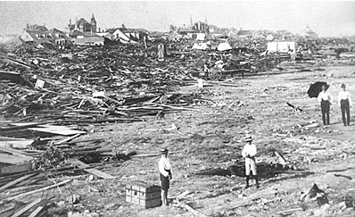
As a deadly hurricane bears down on the Texas gulf coast, I thought I'd write a requiem post for the 8,000 souls who died in the 1900 storm that devastated Galveston, which was then the fourth-largest city in Texas.

The 1900 storm hit with no advance warning - it was long before satellite tracking, radar, or reliable forecasts (in the absence of professional meteorology, the storm also had no name). Five days after the storm, a Galveston Daily News reporter wrote,
The story of Galveston's tragedy can never be written as it is... But in the realm of finity, the weak and staggered senses of mankind may gather fragments of the disaster, and may strive with inevitable incompleteness to convey the merest impression of the saddest story which ever engaged the efforts of a reporter.

The quote and photograph come from a Galveston Daily News website dedicated to memorializing the 1900 storm.

After the storm, the city participated in a massive effort to raise the elevation of the island's most flood-prone areas, by as much as 16 feet. To me, the raising of Galveston exemplifies Texas's incredible capacity for revival and growth. It was an incredible feat of civic effort and engineering, executed with turn-of-the-century technology.

Entire structures were jacked up into the air and put on stilts:

St. Patrick's Church, Galveston: from the Texas State Library and Archives.

Avenue O residence, Galveston. Note the front stairway suspended in midair. From the Texas State Library and Archives.

Then, massive pipes were laid in the streets, and dredges began to flood the ground beneath the stilts with mud...
Pipelines discharging dredged fountains of muddy fill. From the Texas State Library and Archives.

...until the ground rose up to meet the bottoms of the raised buildings, and the stilts were buried.

Before and after. This photo comes from Pruned.

In the century since, rising seas and geological subsidence have brought Galveston's elevation as much as 2.5 feet closer to sea level. That also brings the city 2.5 critical feet closer to disaster as Hurricane Ike bears down on the barrier island tonight. Worse still, the past few decades have brought intense development of new homes and businesses to the western end of the island, areas unprotected by the city of Galveston's raised grade or seawall.

This storm could be really ugly for southeastern Texas. Let's hope for the best.