The Black Belt: How Soil Types Determined the 2008 Election in the Deep South
Edit: credit for the original insight on the cotton-electoral connection seems to belong to Allen Gathman, a biology professor at SE Missouri State University. The Pin-the-Tail blog referenced previously seems to have picked it up later and failed to attribute the source; the post below has been corrected accordingly.
This is not a political blog. However, this is a story I couldn't pass up: the story of how voting patterns in the 2008 election were essentially determined 85 million years ago, in the Cretaceous Period. It's also a story about how soil science relates to political science, by way of historical chance.
It's also a story best told with maps, beginning with this one:

This is the map showing county-level election results in the southeastern USA, courtesy of the New York Times website. Most of these are "red" states, but the county-level detail shows an interesting phenomenon: a crescent of blue that runs in an arc from the Mississippi River floodplain to central North Carolina. This had struck me as curious when I saw it after the election, but I regret that I didn't investigate it further until the story was explained over the weekend on the Strange Maps blog.
Allen Gathman, a biology professor in Missouri, had also seen the pattern and recognized it as a function of land use in the deep South. He posted the electoral map above alongside a map of cotton production in 1860: sure enough, the "blue" counties correlated with cotton production in the slavery era. Here's a mash-up of the two maps from Strange Maps contributor Mark Root-Willey:

Each dot in the overlay map represents 2,000 bales of cotton production in 1860. Recall from your American history class that cotton production, a high-value but labor-intensive industry, was one of the prime economic reasons why Southern states chose to maintain the institution of slavery instead of maintaining the Union.
Fascinating stuff, but these maps reminded me that I had seen a similar pattern before, in satellite maps like this one:
View Larger Map
There's that crescent again. A closer look reveals that the lighter-colored band in the satellite image consists mostly of agricultural fields. Here's a detail of Noxubee County, one of the blue counties in eastern Mississippi that's located in the middle of the crescent:
View Larger Map
It turns out that this crescent actually has a name: the "Black Belt," a name that refers both to the area's racial demographics and to the rich, loamy soils that were ideal for cotton crops.
Allen Tullos of Emory University has an excellent essay on the Black Belt that's available online from the Southern Spaces journal. His article observes that
To review so far: the blue counties can be explained by the black population, whose ancestors were brought there because of white supremacy, and black soil.
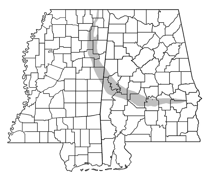
But how did the soil get there, and why is it in this unusual crescent-shaped band? In an essay on the area's ecology, Joe MacGown, Richard Brown, and JoVonn Hill of the Mississippi Entomological Museum write that "the entire region is underlain by Selma Chalk formed from Upper Cretaceous marine deposits. Depending on the exact consistency of the parent material, the chalk weathers into a variety of soil types which supports a mosaic of habitats ranging from prairie to forest." Here's their map of this geological formation - look familiar?
One last map to bring it full circle, from blue counties, to ancient blue seas. Below are two maps of North America in the late Cretaceous Period, made by Professor of Geology Ron Blakey at the University of Northern Arizona. The map on the left shows the South during the early Cretaceous, about 115 million years ago, and the map on the right shows the South during the Late Cretaceous, about 85 million years ago. These shallow, tropical seas, teeming with marine life, laid the deposits that would eventually become the rich "black belt" soils. Note how the crescent of cotton farms in 1860, and of Democratic-voting counties in 2008, also follows the crescent of these ancient shorelines:

For further reading:
Allen Tullos, "The Black Belt." From Southern Spaces, April 2004.
Joe MacGown, Richard Brown, and JoVonn Hill, "The Black Belt in Mississippi." From the Mississippi Entomological Museum.
Ron Blakey, "Paleogeography and Geologic Evolution of North America: Images that track the ancient landscapes of North America"
This is not a political blog. However, this is a story I couldn't pass up: the story of how voting patterns in the 2008 election were essentially determined 85 million years ago, in the Cretaceous Period. It's also a story about how soil science relates to political science, by way of historical chance.
It's also a story best told with maps, beginning with this one:

This is the map showing county-level election results in the southeastern USA, courtesy of the New York Times website. Most of these are "red" states, but the county-level detail shows an interesting phenomenon: a crescent of blue that runs in an arc from the Mississippi River floodplain to central North Carolina. This had struck me as curious when I saw it after the election, but I regret that I didn't investigate it further until the story was explained over the weekend on the Strange Maps blog.
Allen Gathman, a biology professor in Missouri, had also seen the pattern and recognized it as a function of land use in the deep South. He posted the electoral map above alongside a map of cotton production in 1860: sure enough, the "blue" counties correlated with cotton production in the slavery era. Here's a mash-up of the two maps from Strange Maps contributor Mark Root-Willey:
Each dot in the overlay map represents 2,000 bales of cotton production in 1860. Recall from your American history class that cotton production, a high-value but labor-intensive industry, was one of the prime economic reasons why Southern states chose to maintain the institution of slavery instead of maintaining the Union.
Fascinating stuff, but these maps reminded me that I had seen a similar pattern before, in satellite maps like this one:
View Larger Map
There's that crescent again. A closer look reveals that the lighter-colored band in the satellite image consists mostly of agricultural fields. Here's a detail of Noxubee County, one of the blue counties in eastern Mississippi that's located in the middle of the crescent:
View Larger Map
It turns out that this crescent actually has a name: the "Black Belt," a name that refers both to the area's racial demographics and to the rich, loamy soils that were ideal for cotton crops.
Allen Tullos of Emory University has an excellent essay on the Black Belt that's available online from the Southern Spaces journal. His article observes that
Half of Alabama's enslaved population was concentrated within ten Black Belt counties where the exploitation of their labor made this one of the richest regions in the antebellum United States.Tullos's essay also includes a quote from Booker T. Washington, who gave this assessment of the Black Belt in 1901:
"I have often been asked to define the term 'Black Belt.' So far as I can learn, the term was first used to designate a part of the country which was distinguished by the colour of the soil. The part of the country possessing this thick, dark, and naturaly rich soil was, of course, the part of the South where the slaves were most profitable, and consequently they were taken there in the largest numbers. Later, and especially since the war, the term seems to be used wholly in a political sense - that is, to designate the counties where the black people outnumber the white.A hundred years later, the "black belt" still contains a high concentration of African Americans, who, as a demographic group, voted overwhelmingly in favor of Barack Obama.
To review so far: the blue counties can be explained by the black population, whose ancestors were brought there because of white supremacy, and black soil.
But how did the soil get there, and why is it in this unusual crescent-shaped band? In an essay on the area's ecology, Joe MacGown, Richard Brown, and JoVonn Hill of the Mississippi Entomological Museum write that "the entire region is underlain by Selma Chalk formed from Upper Cretaceous marine deposits. Depending on the exact consistency of the parent material, the chalk weathers into a variety of soil types which supports a mosaic of habitats ranging from prairie to forest." Here's their map of this geological formation - look familiar?
One last map to bring it full circle, from blue counties, to ancient blue seas. Below are two maps of North America in the late Cretaceous Period, made by Professor of Geology Ron Blakey at the University of Northern Arizona. The map on the left shows the South during the early Cretaceous, about 115 million years ago, and the map on the right shows the South during the Late Cretaceous, about 85 million years ago. These shallow, tropical seas, teeming with marine life, laid the deposits that would eventually become the rich "black belt" soils. Note how the crescent of cotton farms in 1860, and of Democratic-voting counties in 2008, also follows the crescent of these ancient shorelines:

For further reading:
Allen Tullos, "The Black Belt." From Southern Spaces, April 2004.
Joe MacGown, Richard Brown, and JoVonn Hill, "The Black Belt in Mississippi." From the Mississippi Entomological Museum.
Ron Blakey, "Paleogeography and Geologic Evolution of North America: Images that track the ancient landscapes of North America"



 In Defense of Food
 The Omnivore's Dilemma
 The Botany of Desire