Tuesday, November 24, 2009

Archaeology of the Space Age

In the previous century, our ancestors went to the moon.

They left Earth in antique capsules perched on top of a million pounds of explosives - the largest rockets ever built.

They navigated with wristwatches, slide-rules, and primitive computers with less processing power than a basic cellphone.

And they took pictures. America's first unmanned satellites carried chemical darkrooms on board, where film was developed, translated into radio waves, and beamed back to Earth. On the ground, the satellites' analog photographic data was stored on magnetic tapes.

And then we forgot about them.

The original data for our earliest pictures of the moon, like the one at left, were very nearly lost - the tapes were filed away, and the machines necessary to translate them into images again were discarded as government surplus.

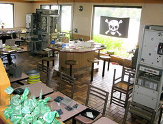
But a few years ago, a team of technological archaeologists, working in an abandoned McDonald's restaurant, recovered the tapes and painstakingly re-constructed the antique equipment required to translate their data into images.

The Apollo-era tape-readers themselves had been saved by a former NASA planetary phtographer, Nancy Evans, who stored several of the wardrobe-sized machines in her garage for decades in the hope that someone, someday, would want to recover the photos.

It's a pretty remarkable project - as though the complete journals of Sir Walter Raleigh had been found written in an obscure Elizabethan code, and the only way to translate the treasure were by refurbishing a heavy cabinet full of derelict gears and pulleys that someone had found in a cobwebbed dungeon of the Tower of London.


The archivists are working not in a museum, but in a defunct burger joint, with the tapes piled on the floor next to the grills, and a pirate flag hanging from the window. In this headquarters of the Lunar Orbiter Image Recovery Project (LOIRP), workers are rehabbing the old machinery with the goal of recovering and digitizing the old images in their original level of detail.

It's a digital archaeological expedition: recovering precious artifacts of the space age, using machines whose operations have been forgotten, in a fast-food ruin.

The Lunar Orbiter missions produced images of extremely fine detail in order to scout landing and exploration sites for the manned missions. In fact, one reason behind the restoration project is because they're still some of the most detailed images we have of the moon's surface, and NASA is interested in going back.

At the time, due to security concerns about revealing the capabilities of American satellites, the public only ever saw second-hand images - photographs of the original photographs. The LOIRP project will not only digitize these landmark images; they'll also make them available to the public for the first time in all their glory.


Above: crew sleeping quarters and tapes in the McDonald's kitchen. Each canister contains one photograph's worth of data. Photo by jurvetson on flickr.

Read more:

NASA: LOIRP images

KN6DJMJUJGFU

Sunday, November 22, 2009

The Skies of L.A.

Last month in Houston I met the author of L.A. Places, a blog about the city's most interesting buildings, public art, hikes, and parks. It makes me want to visit southern California again.

I really liked her photos of these murals inside the public transit agency's headquarters building. They are titled "Los Angeles Circa 1879, 1910, 1950, and after 2000," respectively, by James Doolin.

"Los Angeles, Circa 1879":

"Los Angeles, Circa 1910":

Los Angeles, Circa 1950:
"Los Angeles, Circa After 2000":
What I really like about these murals is how LA's atmosphere is as much of a character as the city itself. As the city grows from a landscape of farms to a landscape of freeways, the sky above it transforms from a pristine blue to a smoggy, orange blanket of haze. The last mural - depicting the city as it is today - looks like something out of Blade Runner.

You can see more murals from LA's transit stations, and lots of other awesome things in Los Angeles, at Vanessa's blog.

Thursday, November 19, 2009

Foreshadowing from 1962

Grist uncovered this ironic ad for Humble Oil (motto: "Happy motoring!") in a 1962 back-issue of Life Magazine on Google Books. Incidentally, Humble was one of several companies that would merge to become ExxonMobil.


Wednesday, November 11, 2009

Canada's Skateways


I love winter - it's a big reason I left Houston and moved home to Maine.

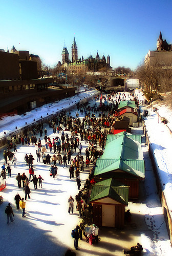
But the Canadians really know how to enjoy the season. In Ottawa, for instance, the frozen Rideau Canal becomes a 5-mile long skating rink every winter. The "Rideau Canal Skateway," pictured above, extends from the campus of Carleton University south of the city center to downtown's Confederation Park, just three blocks away from Canada's Parliament Hill.

This means that Ottawans who live in the city's inner neighborhoods and work downtown are actually able to commute by ice-skates in the winter. And many of them do.

I was going to make this post exclusively about the Rideau Canal, until I found that the city of Winnipeg has copied the idea and gone one better, by opening "the world's longest skating rink" (1 mile longer than Ottawa's) on that city's frozen Assiniboine River. The Assiniboine River Trail, mapped below, is more of a skating path than a skating rink, but the idea of skating to cover long distances is the same.


Winnipeg's skating path extends from Assiniboine Park, not far from the airport in the city's western suburbs, to The Forks, where the Assiniboine meets the Red River. Along the way it passes through several city neighborhoods, and skirts past the southern boundaries of the Manitoban capitol grounds and the downtown business district.

Here's a time-lapse trip down the Assiniboine skate path from YouTube:


Writing this post makes me look forward to winter even more. So when is this good idea from the Canadians going to catch on south of the border?

Thursday, November 05, 2009

Baggers

PBS has recently been broadcasting a long documentary series called National Parks: America's Best Idea. I haven't seen it, but apparently one of the co-producers, a fellow named Dayton Duncan, took it upon himself to visit every one of the nation's 58 national parks as a lifelong project. This effort was chronicled in an article headlined Collect 'Em All, published in the July-August edition of the Sierra Club's magazine.

"Collect 'Em All"?

In response, Utne Reader published a good critique by its senior environmental editor, Keith Goetzman. "Park bagging," the act of collecting visits to every park, requires a lot of gasoline and a lot of vacation time, he points out, which makes it an elite and environmentally-unfriendly pursuit.

But his last point is his best one: "The “collect ’em all” mentality goes against a better, nobler impulse, which is to get to know the land intimately," he writes.

When Jess and I worked in the White Mountains of New Hampshire, we encountered hundreds of "peak baggers" trying to collect all 46 of the state's 4000-foot mountains. Most of them were total douchebags, although, for the sake of full disclosure, I have to admit that I myself climbed the 46 peaks through the course of high school. But back then, I also thought that Ayn Rand was a good writer, so there you go.

Grand Canyon National Park, from Wikimedia Commons.

Anyhow, I have lots of stories about New Hampshire peak baggers. Like the crowd of 20 people that showed up at Zealand Falls Hut one bitterly cold and windy Saturday in January, dead-set on finishing a 20-mile loop to "bag" Guyot and Bondcliff mountains with their huge newfoundland dog, Brutus.

Brutus, they told me, was going to be the first dog to "bag" the 46 peaks in the winter season. This was very important to them. I responded that there were 60 mile an hour winds above treeline, which meant that their planned itinerary would leave them exposed to negative-50 degree windchills for several miles on the ridge. "Don't be stupid," to paraphrase.

They opted to be stupid, of course. They were too late coming back to stop by the hut again, but I heard later through the grapevine that they'd had a miserable trip, and they'd come quite close to leaving a big dog's frozen corpse on the ridge.

Safety and common sense aside, what's really problematic about the baggers' attitude is how it reduces these places - mountain peaks or national parks - to petty consumption items, things to be ticked off on a list, like beanie babies.

This is entirely antithetical to environmentalism, which requires a nuanced and thoughtful understanding of the natural resources and landscapes that surround us.

The National Parks themselves are fetish objects for most environmentalists. Sure, I like them too. Their spectacular landscapes really do inspire a lot of people, including a lot of legendary environmental thinkers like John Muir.

But the National Parks are a lousy place to understand our modern society's real relationship with nature. They don't really offer any lessons about where we get our electricity, or our drinking water, or the raw materials that the Chinese use to forge our consumer goods. Instead, the National Parks offer us an unrealistic vision of the way environmentalists wish things were - a pretty backdrop without any people in it. At their worst (as when the federal army forcefully exiled native tribes like the Blackfoot from parks like Yellowstone and Glacier), the parks themselves could be thought of as costly consumption items tailor-made for "environmentalists."

Organizations like the Nature Conservancy are focused on acquiring land for the cause of environmentalism; hikers acquire mountain climbs; RVers acquire National Park passport stamps. But an environmentalist ethic that's focused on acquisition is an ethic that can not and will not address the fundamental environmental crises of our times.

Tuesday, November 03, 2009

Houston, in bumper stickers

I'm back from a long month of being away from home, thanks to various projects and vacations. The good news is that all of the travel has given me lots of things to write about.

Two weekends ago Jess and I were in Houston for Seth and Maria's wedding. It was really fun, and reminded me how much I love that city. Here's the back of a minivan I found parked in the progressive/gentrifying Montrose neighborhood:


Sure, it's a bit of a contradiction. But when your city is the "energy capital of the world," home to most of the global economy's biggest energy firms as well as dozens of refineries and power plants, you'll find a lot of opinions about energy policy. I certainly don't always agree with them, but I certainly wouldn't dismiss their ideas out of hand, either.

The desire to choose clean wind energy AND drill more oil wells probably reflects this car owner's opinion that what kind of energy we burn is less important than where we get it from - and that it's better to generate energy close to home than import it from dangerous overseas petro-states.

I half agree with this sentiment. If we must burn oil (and it's the rare environmentalist who does not), it would certainly be better if we produced that oil close to home, so that we can at least be honest with ourselves about the consequences of oil extraction and refining, instead of exporting those problems Somewhere Else.

As it is, most of Houston's air pollution, which is some of the worst in the nation, comes from its cluster of oil refiners, which supply gasoline and heating oil to the rest of the nation. Because New England wants gasoline, but doesn't want oil refineries, we're effectively exporting train-loads of toxic air pollution to poor areas of East Texas and Louisiana. [see "Exporting Pollution to Dixie," December 2007].

By producing and refining much of their oil locally, at least Texan consciences can be cleared of our blue-state petro-hypocrisy. I suspect that if any New England or "left-coast" state were forced to refine its oil products locally, they'd probably get a lot more serious about reducing their oil consumption. As it is, they're happy to make it Texas's problem, and Texas is happy to take their money for it.

Besides its slightly more honest position in the sad story of America's oil addiction, the Lone Star State also produces more wind power than any other state (almost three times more than California, the second-biggest wind power producer).

Saturday, October 03, 2009

Out of the Office

I'm headed out this weekend on a trip through northern Maine's "100 mile wilderness," the northernmost section of the Appalachian Trail between Monson and Katahdin.

I'll be incommunicado for the next 8 days but hope to return with lots of new blogging material about nineteenth-century logging artifacts, remote hunting camps, and moose in rut.

Thursday, October 01, 2009

The Future Portland, Oregon, as Envisioned by Robert Moses

The other Portland's weekly Mercury published a great article last week about that city's planned-but-unbuilt freeways. The west-coast Portland is very much in love with itself in general, but the fact that it had the foresight in the 1970s to reject millions of dollars in freeway funds, and re-appropriate the money for the first line in its growing light rail network, is something that it should legitimately be proud of. In the decades since, a number of conventional-wisdom-bucking decisions like this one have made the city what it is today, a leader in urban planning and design.

Before the city abandoned its plans for the Mount Hood Freeway or tore out its waterfront Harbor Drive expressway, though, it was gleefully subscribing to the same happy-motoring, urban-renewal fads that poisoned so many other American cities in the second half of the twentieth century. During World War II, the city commissioned an infrastructure plan from Robert Moses, the same "master builder" who bulldozed hundreds of New York City blocks in order to build new freeways to the suburbs of Connecticut and Long Island.

In a follow-up blog post, Mercury writers posted a PDF copy of the Moses report, which calls for an inner-city loop of grade-separated freeways around Portland's downtown. This loop actually did get built in a slightly modified form, as Interstates 5 and 405.

It's striking to see how the city developed in the neighborhoods where actual freeway construction deviated from Moses's plans. Moses's proposal for an East Side freeway probably would be more appealing to Portlanders than what actually got built: while Moses suggested a route through the industrial neighborhood a few blocks away from the river, the city built the freeway right on the Willamette's eastern bank instead.

Moses also proposed a "Foothill Thruway" that would hug the base of Portland's West Hills, through the neighborhoods of Goose Hollow and cutting diagonally through the city's tony NW 23rd Avenue neighborhood. Here's an illustration from the report:

The caption is vague, but by reading the report's description of the proposed route ("a crossing of Burnside Street near the intersection of King Street... crossing Jefferson Street between Eighteenth and Nineteenth Avenues") and looking at maps, this seems to be a westward-looking view of the Goose Hollow neighborhood. I think that the stadium visible at the lower edge of this drawing is today's PGE Park, next door to the Multnomah Athletic Club, a country-clubbish place where I worked through college as a lifeguard. Here's what the neighborhood looks like today:

High-rise condos and apartment buildings occupy the land that Moses had envisioned for freeway on-ramps, and the neighborhoods of Northwest Portland that would have been bulldozed now host some of the city's most valuable retail and residential properties.

Not to say that the city avoided the destruction altogether; the foothills freeway became I-405, which required the demolition and excavation of about 50 city blocks along the western edge of downtown in the mid-1960s.

In a failed bid for the 1968 Olympics, city boosters/saboteurs published a much more ambitious freeway-development plan, which included the infamous Mount Hood Freeway and many others. Oregon's Cafe Unknown blog has a history of the Olympic bid and a few images from the city's Olympic plans, which mostly consist of suburban stadia surrounded by huge parking lots. A map of the ambitious plans for the freeway network is about 2/3rds of the way down the post.

Moses's report was published in 1943, about a decade before the freeway construction binge caused by Eisenhower's interstate highway development bill. In addition to the freeway plans, Moses included a lot more mundane and uncontroversial advice for improving parks, playgrounds, and sewers.

Still, as commenter "atomic" notes in the Mercury's blog post, it's "strange to think that something so apocalyptic was going on in Europe and Asia, and dudes over here were planning how we were going to manage traffic jams when we were done with it."